Bar nearby Andaman
Israel
Bar nearby Andaman
Andaman
8, Derech HaAtsma'ut, Yahud Monoson, Petach Tikva, IL Israel
contacts phone
:
+972 50-866-2020
Latitude:
32.0279815
, Longitude:
34.885083
larger map & directions
read more
nearest Bar
1.369 km
Gray Club
Ha-Kharoshet Street 2, Yehud
Bar
read more
2.488 km
Sparrow Brewery - מבשלת ספארו
David Navon Street 33, Magshimim
Bar
read more
2.488 km
Sparrow Brewery - מבשלת ספארו
דוד נבון 33, מגשימים
Bar
read more
3.675 km
דון ויטו
דרך לוד, אור יהודה
Bar
read more
3.675 km
Don Vito
Lod Road, Or Yehuda
Bar
read more
5.251 km
פאב החממה
Derech Sheba, כפר אזר
Bar
read more
5.251 km
פאב החממה
דרך שיבא, כפר אזר
Bar
read more
5.884 km
הסושיה
Petah Tikva
Bar
read more
9.473 km
Beer Street
Bialik Street 77, Ramat Gan
Bar
read more
10.027 km
Hadar Dimal Hall
רח' זאב ז'בוטינסקי 1, רמת גן
Bar
read more
10.074 km
אידאה
מוהליבר 35, ראשון לציון
Bar
read more
10.177 km
Tirtza's Cinema
Herzl Street 34, Rishon LeTsiyon
Bar
read more
10.625 km
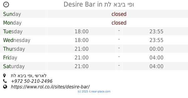
Desire Bar
תל אביב יפו
Bar
read more
10.805 km
bruno rlz
Jabotinsky Street 16, Rishon LeTsiyon
Bar
read more
11.381 km
בר רוטשילד 22
נחלת בנימין 65, תל אביב יפו
Bar
read more
11.381 km
בר רוטשילד 22
Nahalat Binyamin Street 65, Tel Aviv-Yafo
Bar
read more
11.635 km
הגרעין
3361 22, תל אביב יפו
Bar
read more
11.663 km
איבני
Arlozorov Street 81, Tel Aviv-Yafo
Bar
read more
11.872 km
חלל - The Space
Malan Street 43, Tel Aviv-Yafo
Bar
read more
11.982 km
באסטה בר
מל"ן, תל אביב יפו
Bar
read more
12.034 km
Barakuda
Allenby Street 27, Tel Aviv-Yafo
Bar
read more
12.217 km
Fasada
Dizengoff Street 196, Tel Aviv-Yafo
Bar
read more
12.336 km
Imperial Cocktail Bar
HaYarkon Street 66, Tel Aviv-Yafo
Bar
read more
12.445 km
Margoza Bar
Rabbi Yohanan Street 3, Tel Aviv-Yafo
Bar
read more
12.529 km
Burger Cabana & Bar
Rishon LeTsiyon
Bar
read more
📑
all categories
Accounting
Administrative area level 1
Administrative area level 2
Airport
Amusement park
Aquarium
Art gallery
Atm
Bakery
Bank
Bar
Beauty salon
Bicycle store
Book store
Bowling alley
Bus station
Cafe
Campground
Car dealer
Car rental
Car repair
Car wash
Casino
Cemetery
Church
City hall
Clothing store
Colloquial area
Convenience store
Country
Courthouse
Dentist
Department store
Doctor
Electrician
Electronics store
Embassy
Establishment
Finance
Fire station
Florist
Food
Funeral home
Furniture store
Gas station
General contractor
Grocery or supermarket
Gym
Hair care
Hardware store
Health
Hindu Temple
Home goods store
Hospital
Insurance agency
Intersection
Jewelry store
Laundry
Lawyer
Library
Light rail station
Liquor store
Local government office
Locality
Locksmith
Lodging
Meal delivery
Meal takeaway
Mosque
Movie rental
Movie theater
Moving company
Museum
Natural feature
Neighborhood
Night club
Painter
Park
Parking
Pet store
Pharmacy
Physiotherapist
Place of worship
Plumber
Point of interest
Police
Political
Post office
Premise
Real estate agency
Restaurant
Roofing contractor
Route
Rv park, camping
School
Shoe store
Shopping mall
Spa
Stadium
Storage
Store
Subpremise
Subway station
Supermarket
Synagogue
Taxi stand
Train station
Transit station
Travel agency
University
Veterinary care
Zoo
administrative area level 3
administrative area level 4
sublocality level 1
↑