Bar nearby Alla Rampa
Coronavirus disease (COVID-19) Situation
confirmed cases
4841772
deaths
12707
Israel
Bar nearby Alla Rampa
Alla Rampa
21, Ha'Amal Street, Tel Aviv-Yafo, IL Israel
contacts phone
:
+972 3-546-1506
website:
facebook.com
Latitude:
32.0523771
, Longitude:
34.7732671
larger map & directions
read more
nearest Bar
156 m
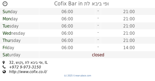
Cofix Bar
שוקן 32, תל אביב יפו
Bar
read more
432 m
Vintage
Florentin Street 55, Tel Aviv-Yafo
Bar
read more
458 m
מיידל'ה
Florentin Street, Tel Aviv-Yafo
Bar
read more
636 m
צ'ירס פלורנטין
חיים ויטאל 13, תל אביב יפו
Bar
read more
650 m
Florencheers
Chayim Vital Street 13, Tel Aviv-Yafo
Bar
read more
662 m
נייט שיפט
ויטל 9, תל אביב יפו
Bar
read more
662 m
Night Shift
ויטל 9, תל אביב יפו
Bar
read more
665 m
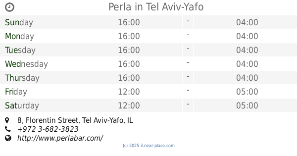
Perla
Florentin Street 8, Tel Aviv-Yafo
Bar
read more
676 m
קומיקס בר Comics Bar
Zevulun Street 30, Tel Aviv-Yafo
Bar
read more
677 m
Lenny's
Chayim Vital Street 7, Tel Aviv-Yafo
Bar
read more
694 m
מייט פלורנטין
חיים ויטאל 4, תל אביב יפו
Bar
read more
694 m
Mate florentin
Chayim Vital Street 4, Tel Aviv-Yafo
Bar
read more
716 m
פימפינלה
Nahalat Binyamin Street 115, Tel Aviv-Yafo
Bar
read more
726 m
מתי המקלל
Matalon Street 41, Tel Aviv-Yafo
Bar
read more
737 m
Cocktails & Dreams
HaRav Yizkhak Yedidya Frenkel 4, Tel Aviv-Yafo
Bar
read more
737 m
Cocktails & Dreams
הרב יצחק ידידיה פרנקל 4, תל אביב יפו
Bar
read more
844 m
המקום של בני
לוינסקי 41, תל אביב יפו
Bar
read more
853 m
הגרעין
3361 22, תל אביב יפו
Bar
read more
863 m
בר חנניה
3361 22, תל אביב יפו
Bar
read more
885 m
HaHalutzim Pub
Ha-Khalutzim Street 3, Tel Aviv-Yafo
Bar
read more
921 m
Диего Сан
Ha-Mashbir Street 2, Tel Aviv-Yafo
Bar
read more
956 m
Teder.fm
בית רומנו, דרך יפו 9, תל אביב יפו
Bar
read more
1.061 km
Norma Jean
Elifelet Street 23, Tel Aviv-Yafo
Bar
read more
1.078 km
ROGER'S HOUSE TEL AVIV
17, Aharon Chelouche Lane, Tel Aviv-Yafo
Bar
read more
1.264 km
Pinoy Hotspot
בית עמנואל, הצפירה 10, תל אביב יפו
Bar
read more
📑
all categories
Accounting
Administrative area level 1
Administrative area level 2
Airport
Amusement park
Aquarium
Art gallery
Atm
Bakery
Bank
Bar
Beauty salon
Bicycle store
Book store
Bowling alley
Bus station
Cafe
Campground
Car dealer
Car rental
Car repair
Car wash
Casino
Cemetery
Church
City hall
Clothing store
Colloquial area
Convenience store
Country
Courthouse
Dentist
Department store
Doctor
Electrician
Electronics store
Embassy
Establishment
Finance
Fire station
Florist
Food
Funeral home
Furniture store
Gas station
General contractor
Grocery or supermarket
Gym
Hair care
Hardware store
Health
Hindu Temple
Home goods store
Hospital
Insurance agency
Intersection
Jewelry store
Laundry
Lawyer
Library
Light rail station
Liquor store
Local government office
Locality
Locksmith
Lodging
Meal delivery
Meal takeaway
Mosque
Movie rental
Movie theater
Moving company
Museum
Natural feature
Neighborhood
Night club
Painter
Park
Parking
Pet store
Pharmacy
Physiotherapist
Place of worship
Plumber
Point of interest
Police
Political
Post office
Premise
Real estate agency
Restaurant
Roofing contractor
Route
Rv park, camping
School
Shoe store
Shopping mall
Spa
Stadium
Storage
Store
Subpremise
Subway station
Supermarket
Synagogue
Taxi stand
Train station
Transit station
Travel agency
University
Veterinary care
Zoo
administrative area level 3
administrative area level 4
sublocality level 1
↑