Bank nearby הבנק הבינלאומי
Israel
Bank nearby הבנק הבינלאומי
הבנק הבינלאומי
40, Tsofit Street, Ramla, Ramla, IL Israel
contacts phone
:
+972
website:
www.fibi.co.il
Latitude:
31.9327355
, Longitude:
34.8891617
larger map & directions
read more
nearest Bank
7 m
הבנק הבינלאומי
Ramla
Bank
read more
1.478 km
בנק הפועלים
שדרות הציונות 1, לוד
Bank
read more
1.478 km
Банк Ха-Поалим
Sderot Hatsiyonut 1, Lod
Bank
read more
1.624 km
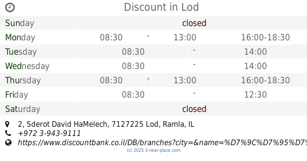
דיסקונט
Sderot David HaMelech 2, Lod
Bank
read more
1.624 km
Discount
Sderot David HaMelech 2, Lod
Bank
read more
1.639 km
מרכנתיל
Sderot Herzl 75, Ramla
Bank
read more
1.639 km
Mercantile
Sderot Herzl 75, Ramla
Bank
read more
1.646 km
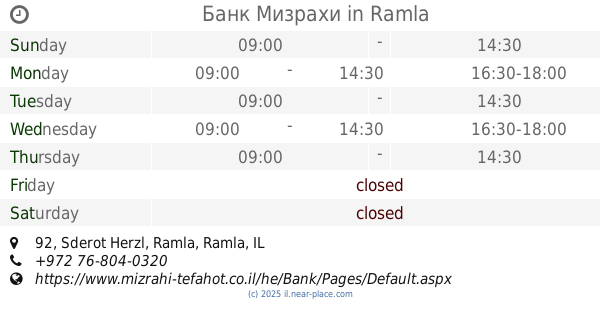
Банк Мизрахи
Sderot Herzl 92, Ramla
Bank
read more
1.646 km
Mizrahi-Tefahot
Sderot Herzl 92, Ramla
Bank
read more
1.646 km
מזרחי טפחות
שדרות הרצל 92, רמלה
Bank
read more
1.646 km
דיסקונט Discount
Sderot David HaMelech 2, Lod
Bank
Finance
Point of interest
Establishment
read more
1.736 km
הבנק הבינלאומי
Sderot Herzl 63, Ramla
Bank
read more
1.785 km
דיסקונט
שדרות הרצל 55, רמלה
Bank
read more
1.785 km
דיסקונט
Sderot Herzl 55, Ramla
Bank
read more
1.785 km
Discount
Sderot Herzl 55, Ramla
Bank
read more
1.788 km
בנק לאומי לוד
לוד
Bank
read more
1.788 km
דיסקונט Discount
Sderot Herzl 59, Ramla
Bank
Finance
Point of interest
Establishment
read more
1.788 km
Банк Леуми
Lod
Bank
read more
1.789 km
בנק לאומי לוד
Lod
Bank
Finance
Point of interest
Establishment
read more
1.816 km
Bank Leumi
Sderot Herzl 84, Ramla
Bank
read more
1.816 km
בנק לאומי
שדרות הרצל 84, רמלה
Bank
read more
1.82 km
Discount Bank Ltd
Sderot Herzl 55, Ramla
Bank
Finance
Point of interest
Establishment
read more
1.873 km
Bank Hapoalim
Dani Mas Street 7, Ramla
Bank
Finance
Point of interest
Establishment
read more
1.88 km
Банк Ха-Поалим
Dani Mas Street 7, Ramla
Bank
read more
1.88 km
בנק הפועלים
דני מס 7, רמלה
Bank
read more
📑
all categories
Accounting
Administrative area level 1
Administrative area level 2
Airport
Amusement park
Aquarium
Art gallery
Atm
Bakery
Bank
Bar
Beauty salon
Bicycle store
Book store
Bowling alley
Bus station
Cafe
Campground
Car dealer
Car rental
Car repair
Car wash
Casino
Cemetery
Church
City hall
Clothing store
Colloquial area
Convenience store
Country
Courthouse
Dentist
Department store
Doctor
Electrician
Electronics store
Embassy
Establishment
Finance
Fire station
Florist
Food
Funeral home
Furniture store
Gas station
General contractor
Grocery or supermarket
Gym
Hair care
Hardware store
Health
Hindu Temple
Home goods store
Hospital
Insurance agency
Intersection
Jewelry store
Laundry
Lawyer
Library
Light rail station
Liquor store
Local government office
Locality
Locksmith
Lodging
Meal delivery
Meal takeaway
Mosque
Movie rental
Movie theater
Moving company
Museum
Natural feature
Neighborhood
Night club
Painter
Park
Parking
Pet store
Pharmacy
Physiotherapist
Place of worship
Plumber
Point of interest
Police
Political
Post office
Premise
Real estate agency
Restaurant
Roofing contractor
Route
Rv park, camping
School
Shoe store
Shopping mall
Spa
Stadium
Storage
Store
Subpremise
Subway station
Supermarket
Synagogue
Taxi stand
Train station
Transit station
Travel agency
University
Veterinary care
Zoo
administrative area level 3
administrative area level 4
sublocality level 1
↑