Bakery nearby תושה בייקרי
Israel
Bakery nearby תושה בייקרי
תושה בייקרי
כפר ראש הניקרה, ישראל
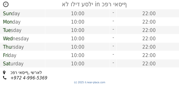
contacts phone
:
+972 52-839-9795
website:
www.facebook.com
Latitude:
33.0860515
, Longitude:
35.1141256
larger map & directions
read more
nearest Bakery
3.283 km
Кондитерская Вольфсон wolfsoncakes.com
Row 4 , the industrial zone, Shlomi
Bakery
read more
3.291 km
קונדיטוריה וולפסון
שורה 4, איזור התעשייה, Shlomi
Bakery
read more
3.291 km
קונדיטוריה וולפסון
David Ben Gurion Street 257, Shlomi
Bakery
read more
4.96 km
לחם טנא
גשר הזיו
Bakery
read more
8.763 km
מאפיית מקור הלחם
Derech Yehi'am 4, Nahariyya
Bakery
read more
8.793 km
Dudu Outmezgin la patisserie
Herzl Street 59, Nahariyya
Bakery
read more
8.834 km
מאפיית לחם חמודות
דרך יחיעם 11, נהריה
Bakery
read more
8.89 km
אושרה עוגות מעוצבות
הזמיר 84 דירה 28, נהריה
Bakery
read more
8.921 km
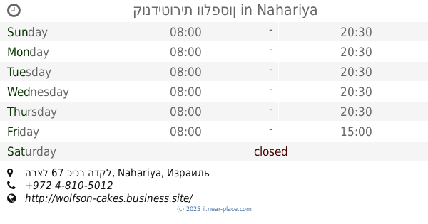
קונדיטורית וולפסון
הרצל 67 כיכר הדקל, Nahariyya
Bakery
read more
8.96 km
מאפיית מרכז הלחם
נהריה
Bakery
read more
8.992 km
Pastry Pie
Sderot HaGa'aton 28, Nahariyya
Bakery
read more
9 km
מאפיית מנחת הארץ
שדרות הגעתון 2, נהריה
Bakery
read more
9.002 km
רגעים מתוקים עם אתי
בן עמי, עכו
Bakery
read more
9.009 km
מאפיית אריאל
וייצמן 62, נהריה
Bakery
read more
9.046 km
טריקולד
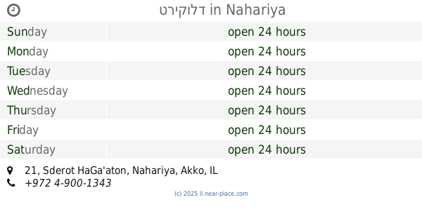
Sderot HaGa'aton 21, Nahariya
Bakery
Cafe
Food
Point of interest
Store
Establishment
read more
9.096 km
מרכז בית מאפה
לוחמי הגטאות 3, נהריה
Bakery
read more
9.124 km
קונדיטוריה יסמין
לוחמי הגטאות 3, נהריה
Bakery
read more
9.147 km
מאפיית שילת
הרצל 77, נהריה
Bakery
read more
14.812 km
Bakery Alhnin
Abu Snan
Bakery
read more
14.972 km
תנור אל בלד
כפר יאסיף
Bakery
read more
15.326 km
אל וליד עסלי
כפר יאסיף
Bakery
read more
15.326 km
Al Walid Asali
Kafr Yasif
Bakery
read more
16.358 km
לחם בר
HaShuk Street 1, Ma'alot-Tarshiha
Bakery
read more
16.732 km
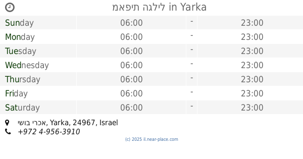
מאפית הגליל
ישוב ירכא
Bakery
Supermarket
Grocery or supermarket
Food
Point of interest
Store
Establishment
read more
17.09 km
מאפית המעין
Unnamed Road, ירכא
Bakery
read more
📑
all categories
Accounting
Administrative area level 1
Administrative area level 2
Airport
Amusement park
Aquarium
Art gallery
Atm
Bakery
Bank
Bar
Beauty salon
Bicycle store
Book store
Bowling alley
Bus station
Cafe
Campground
Car dealer
Car rental
Car repair
Car wash
Casino
Cemetery
Church
City hall
Clothing store
Colloquial area
Convenience store
Country
Courthouse
Dentist
Department store
Doctor
Electrician
Electronics store
Embassy
Establishment
Finance
Fire station
Florist
Food
Funeral home
Furniture store
Gas station
General contractor
Grocery or supermarket
Gym
Hair care
Hardware store
Health
Hindu Temple
Home goods store
Hospital
Insurance agency
Intersection
Jewelry store
Laundry
Lawyer
Library
Light rail station
Liquor store
Local government office
Locality
Locksmith
Lodging
Meal delivery
Meal takeaway
Mosque
Movie rental
Movie theater
Moving company
Museum
Natural feature
Neighborhood
Night club
Painter
Park
Parking
Pet store
Pharmacy
Physiotherapist
Place of worship
Plumber
Point of interest
Police
Political
Post office
Premise
Real estate agency
Restaurant
Roofing contractor
Route
Rv park, camping
School
Shoe store
Shopping mall
Spa
Stadium
Storage
Store
Subpremise
Subway station
Supermarket
Synagogue
Taxi stand
Train station
Transit station
Travel agency
University
Veterinary care
Zoo
administrative area level 3
administrative area level 4
sublocality level 1
↑