Bakery nearby סטודיו rawia cake&cook
Coronavirus disease (COVID-19) Situation
confirmed cases
4841772
deaths
12707
Israel
Bakery nearby סטודיו rawia cake&cook
סטודיו rawia cake&cook
Daliyat al-Karmel, Israel
contacts phone
:
+972 4-839-7880
Latitude:
32.6836584
, Longitude:
35.068289
larger map & directions
read more
nearest Bakery
1.652 km
Ariel Bakery
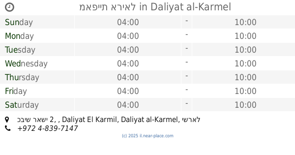
כביש ראשי 2, , Daliyat El Karmil
Bakery
read more
1.652 km
מאפיית אריאל
כביש ראשי 2, , Daliyat El Karmil
Bakery
read more
1.802 km
קונגיטורית-ממתקי דאלית אל כרמל
דאלית אל-כרמל
Bakery
read more
2.15 km
קונדיטורית כנאפת אלבלד
דאלית אל-כרמל
Bakery
read more
2.15 km
Al-Ballad Knaffeh
Daliyat al-Karmel
Bakery
read more
2.207 km
ממתקי עבדאללה
672, Daliyat al-Karmel
Bakery
read more
2.222 km
Mais cakes - עוגות וקינוחים
דאלית אל-כרמל
Bakery
read more
2.222 km
Mais cakes - עוגות וקינוחים
Daliyat al-Karmel
Bakery
read more
2.271 km
קונדיטוריה שפיק
Daliyat al-Karmel
Bakery
read more
3.826 km
כנאפה ובס
Isfiya
Bakery
read more
4.285 km
מאפית פת לחם
יוקנעם עילית
Bakery
read more
4.285 km
מאפית פת לחם
Yokne'am Illit
Bakery
read more
4.339 km
אגמי
Ha-Tamar Street 2, Yokne'am Illit
Bakery
read more
4.367 km
Shafik Bakery
עיספיא
Bakery
read more
4.367 km
Shafik Bakery
Isfiya
Bakery
read more
4.642 km
מאפה ארז
13 11, Ha-Yakinton Street, Yokne'am Illit
Bakery
read more
4.649 km
מאפה ארז
13, היקינטון, יוקנעם עילית
Bakery
read more
4.649 km
מאפה ארז
13, Ha-Yakinton Street, Yokne'am Illit
Bakery
read more
4.69 km
קונדיטוריה אייל גורודצקי
עיספיא
Bakery
read more
5.083 km
הצריף של תמרי ביקנעם
Dan Street 13/1, Yokne'am Illit
Bakery
read more
5.083 km
הצריף של תמרי ביקנעם
דן 13/1, יוקנעם עילית
Bakery
read more
5.103 km
Pat Lehem
Yokne'am Illit
Bakery
read more
15.064 km
מאפיית מיכאל
אסף שמחוני 2-10, קרית אתא
Bakery
read more
15.064 km
Shemo
Moriya Boulevard 30, Haifa
Bakery
read more
15.794 km
העוגה
הרצל 14, חיפה
Bakery
read more
📑
all categories
Accounting
Administrative area level 1
Administrative area level 2
Airport
Amusement park
Aquarium
Art gallery
Atm
Bakery
Bank
Bar
Beauty salon
Bicycle store
Book store
Bowling alley
Bus station
Cafe
Campground
Car dealer
Car rental
Car repair
Car wash
Casino
Cemetery
Church
City hall
Clothing store
Colloquial area
Convenience store
Country
Courthouse
Dentist
Department store
Doctor
Electrician
Electronics store
Embassy
Establishment
Finance
Fire station
Florist
Food
Funeral home
Furniture store
Gas station
General contractor
Grocery or supermarket
Gym
Hair care
Hardware store
Health
Hindu Temple
Home goods store
Hospital
Insurance agency
Intersection
Jewelry store
Laundry
Lawyer
Library
Light rail station
Liquor store
Local government office
Locality
Locksmith
Lodging
Meal delivery
Meal takeaway
Mosque
Movie rental
Movie theater
Moving company
Museum
Natural feature
Neighborhood
Night club
Painter
Park
Parking
Pet store
Pharmacy
Physiotherapist
Place of worship
Plumber
Point of interest
Police
Political
Post office
Premise
Real estate agency
Restaurant
Roofing contractor
Route
Rv park, camping
School
Shoe store
Shopping mall
Spa
Stadium
Storage
Store
Subpremise
Subway station
Supermarket
Synagogue
Taxi stand
Train station
Transit station
Travel agency
University
Veterinary care
Zoo
administrative area level 3
administrative area level 4
sublocality level 1
↑