Bakery nearby רוגעל'ה
Israel
Bakery nearby רוגעל'ה
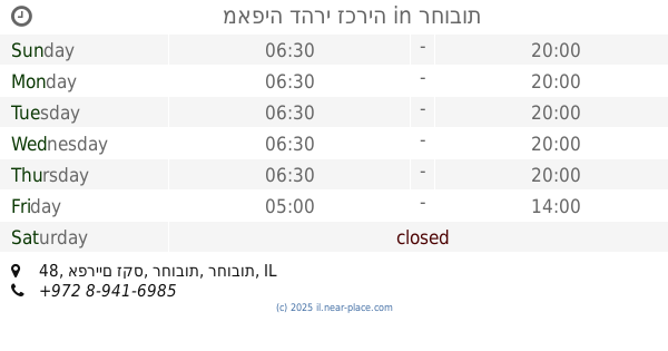
רוגעל'ה
3, Hish Street, Rehovot, Rehovot, IL Israel
contacts phone
:
+972 8-935-1000
website:
www.facebook.com
Latitude:
31.894129
, Longitude:
34.8242436
larger map & directions
read more
nearest Bakery
670 m
פמפושקה - יצירה מתוקה
Nakhum Kesselman Street 7, Rehovot
Bakery
read more
670 m
פמפושקה - יצירה מתוקה
נחום קסלמן 7, רחובות
Bakery
read more
805 m
2 שף מתוקים
יעקב 43, רחובות
Bakery
read more
805 m
2 שף מתוקים
Ya'akov Street 43, Rehovot
Bakery
read more
1.092 km
זבת חלב ודבש
בנימין 9, רחובות
Bakery
read more
1.129 km
קונדיטורית פארין (יאי) בעמ
Herzl Street 146, Rehovot
Bakery
read more
1.166 km
מאפיית קלאסיק בעמ
הרצל 103, רחובות
Bakery
read more
1.166 km
Classic Bakery Inc.
Herzl Street 103, Rehovot
Bakery
read more
1.171 km
פטיסרי - רחובות, Pâtisserie - Rehovot
Ahad Ha'Am Street 4, Rehovot
Bakery
read more
1.234 km
Shaulov Sisters
Rehovot
Bakery
read more
1.28 km
עוגיות ויצמן
רחובות
Bakery
read more
1.28 km
Cookies Weizman
Rehovot
Bakery
read more
1.288 km
מאפיית ג'רפי
הרצל 82, רחובות
Bakery
read more
1.3 km
מאפיית פארין
Herzl Street 82, Rehovot
Bakery
read more
1.301 km
מאפיית ג'רפי
Herzl Street 68, Rehovot
Bakery
read more
1.315 km
מאפיה דהרי זכריה
אפריים זקס 48, רחובות
Bakery
read more
1.33 km
Hot Bagel Bakery
Herzl Street 167, Rehovot
Bakery
read more
1.34 km
שיבולת השרון
הרצל פינת Beit ha-Po'alim Street 167, רחובות
Bakery
read more
1.34 km
שיבולת השרון
הרצל פינת Beit ha-Po'alim Street 167, Rehovot
Bakery
read more
1.419 km
קצת אחרת אצל אידה וזאב - לחם תושיה
בית הפועלים 5, רחובות
Bakery
read more
1.435 km
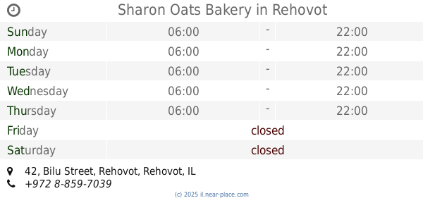
Sharon Oats Bakery
Bilu Street 42, Rehovot
Bakery
read more
1.435 km
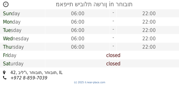
מאפיית שיבולת השרון
ביל"ו 42, רחובות
Bakery
read more
1.516 km
סמי בורקס
הרצל 208, רחובות
Bakery
read more
1.741 km
חואניטה ליברמן - JuaniCakes - עוגות מעוצבות לאירועים וימי הולדת
רמז 61 רחובות IL 7644903, דוד רמז 61, רחובות
Bakery
read more
2.722 km
Arcaffe
פקריס 3 פארק המדע רחובות
Cafe
Bakery
Restaurant
Food
Point of interest
Store
Establishment
read more
📑
all categories
Accounting
Administrative area level 1
Administrative area level 2
Airport
Amusement park
Aquarium
Art gallery
Atm
Bakery
Bank
Bar
Beauty salon
Bicycle store
Book store
Bowling alley
Bus station
Cafe
Campground
Car dealer
Car rental
Car repair
Car wash
Casino
Cemetery
Church
City hall
Clothing store
Colloquial area
Convenience store
Country
Courthouse
Dentist
Department store
Doctor
Electrician
Electronics store
Embassy
Establishment
Finance
Fire station
Florist
Food
Funeral home
Furniture store
Gas station
General contractor
Grocery or supermarket
Gym
Hair care
Hardware store
Health
Hindu Temple
Home goods store
Hospital
Insurance agency
Intersection
Jewelry store
Laundry
Lawyer
Library
Light rail station
Liquor store
Local government office
Locality
Locksmith
Lodging
Meal delivery
Meal takeaway
Mosque
Movie rental
Movie theater
Moving company
Museum
Natural feature
Neighborhood
Night club
Painter
Park
Parking
Pet store
Pharmacy
Physiotherapist
Place of worship
Plumber
Point of interest
Police
Political
Post office
Premise
Real estate agency
Restaurant
Roofing contractor
Route
Rv park, camping
School
Shoe store
Shopping mall
Spa
Stadium
Storage
Store
Subpremise
Subway station
Supermarket
Synagogue
Taxi stand
Train station
Transit station
Travel agency
University
Veterinary care
Zoo
administrative area level 3
administrative area level 4
sublocality level 1
↑