Bakery nearby מאפית חבה
Israel
Bakery nearby מאפית חבה
מאפית חבה
23, Yad Harutsim Street, Jerusalem, IL Israel
contacts phone
:
+972
Latitude:
31.7501865
, Longitude:
35.2156003
larger map & directions
read more
nearest Bakery
310 m
הלחם של תומר
פועלי צדק 4, ירושלים
Bakery
read more
310 m
Tomer's Breads
Po'alei Tsedek Street 4, Jerusalem
Bakery
read more
344 m
מאפיית נחמה בעמ
צרת 15, ירושלים
Bakery
read more
397 m
הולי בייגל | משרד הראשי - Holy Bagel | Head Office
Derech Beit Lehem 120, Jerusalem
Bakery
read more
397 m
קייטרינג הולי בייגל
בית לחם 120, ירושלים
Bakery
read more
397 m
הולי בייגל | משרד הראשי - Holy Bagel | Head Office
Beit Lehem Road 120, Jerusalem
Bakery
read more
409 m
Neeman Bakery
קניון הדר, פייר קניג 24, ירושלים
Bakery
read more
409 m
מאפה נאמן
קניון הדר, פייר קניג 24, ירושלים
Bakery
read more
470 m
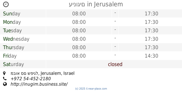
עינוגים
מבוא סם שפיגל, Jerusalem
Bakery
read more
483 m
Bagel Bite
Mavo Sam Spiegel 4, Jerusalem
Bakery
read more
498 m
Taam Tam
Yad Haroutsim 4, Jerusalem
Bakery
read more
498 m
Taam Tam
Yad Haroutsim 4, ירושלים
Bakery
read more
532 m
Burekas Ima
Rivka Street 17, Jerusalem
Bakery
read more
532 m
בורקס אמא מאפיה וקונדיטוריה
רבקה 17, ירושלים
Bakery
read more
533 m
אינגליש קייק
רבקה 19, ירושלים
Bakery
read more
533 m
English Cake
Rivka Street 19, Jerusalem
Bakery
read more
732 m
Tomer's bread
Leib Yafe Street 9, Jerusalem
Bakery
read more
732 m
הלחם של תומר
לייב יפה 9, ירושלים
Bakery
read more
776 m
Roladin
דרך חברון א101, Jerusalem
Cafe
Bakery
Restaurant
Food
Point of interest
Store
Establishment
read more
778 m
מפגש השייח
HaUman Street 23, Jerusalem
Bakery
read more
801 m
מאפה נאמן
האומן 30, ירושלים
Bakery
read more
1.459 km
מרציפן
רחל אמנו 5, ירושלים
Bakery
read more
1.5 km
Ben-Ami
Emek Refa'im Street 38, Jerusalem
Bakery
Cafe
Restaurant
Food
Point of interest
Store
Establishment
read more
1.792 km
Neeman Bakery
Ha-Notrim Street 4, Jerusalem
Bakery
read more
1.928 km
מאפיית אנג׳ל
הפלמ"ח 40, ירושלים
Bakery
read more
📑
all categories
Accounting
Administrative area level 1
Administrative area level 2
Airport
Amusement park
Aquarium
Art gallery
Atm
Bakery
Bank
Bar
Beauty salon
Bicycle store
Book store
Bowling alley
Bus station
Cafe
Campground
Car dealer
Car rental
Car repair
Car wash
Casino
Cemetery
Church
City hall
Clothing store
Colloquial area
Convenience store
Country
Courthouse
Dentist
Department store
Doctor
Electrician
Electronics store
Embassy
Establishment
Finance
Fire station
Florist
Food
Funeral home
Furniture store
Gas station
General contractor
Grocery or supermarket
Gym
Hair care
Hardware store
Health
Hindu Temple
Home goods store
Hospital
Insurance agency
Intersection
Jewelry store
Laundry
Lawyer
Library
Light rail station
Liquor store
Local government office
Locality
Locksmith
Lodging
Meal delivery
Meal takeaway
Mosque
Movie rental
Movie theater
Moving company
Museum
Natural feature
Neighborhood
Night club
Painter
Park
Parking
Pet store
Pharmacy
Physiotherapist
Place of worship
Plumber
Point of interest
Police
Political
Post office
Premise
Real estate agency
Restaurant
Roofing contractor
Route
Rv park, camping
School
Shoe store
Shopping mall
Spa
Stadium
Storage
Store
Subpremise
Subway station
Supermarket
Synagogue
Taxi stand
Train station
Transit station
Travel agency
University
Veterinary care
Zoo
administrative area level 3
administrative area level 4
sublocality level 1
↑