Bakery nearby ברמן
Israel
Bakery nearby ברמן
ברמן
24, בית הדפוס, ירושלים, IL Израиль
contacts phone
:
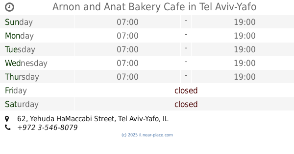
+972 2-654-1989
website:
www.berman.co.il
Latitude:
32.1052374
, Longitude:
34.7900886
larger map & directions
read more
nearest Bakery
703 m
מאפיית לחמים ברודצקי
ברודצקי 15 תל אביב יפו IL 6905126, ברודצקי 15, תל אביב יפו
Bakery
read more
703 m
מאפיית לחמים ברודצקי
ברודצקי 15 תל אביב יפו IL 6905126, Brodetski Street 15, Tel Aviv-Yafo
Bakery
read more
718 m
Toshia Bread
Brodetski Street, Tel Aviv-Yafo
Bakery
read more
718 m
לחם תושיה
Brodetski Street, Tel Aviv-Yafo
Bakery
read more
718 m
Toshia Bread
ברודצקי, תל אביב יפו
Bakery
read more
721 m
מאפיית לחמים
Brodetski Street 15, Tel Aviv-Yafo
Bakery
read more
745 m
לחמים רמת אביב
Brodetski Street, Tel Aviv-Yafo
Bakery
read more
745 m
לחמים רמת אביב
ברודצקי, תל אביב יפו
Bakery
read more
974 m
עוגיגה
Patai Street 14, Yafo
Bakery
read more
974 m
עוגיגה
פטאי 14, Yafo
Bakery
read more
974 m
עוגיגה
פטאי 14, תל אביב יפו
Bakery
read more
984 m
Albertine
Einstein Street 48, Tel Aviv-Yafo
Bakery
read more
993 m
ארקפה - דוכן לחמים
איינשטיין 40, תל אביב יפו
Bakery
read more
993 m
Arcafe - Bakery
Einstein Street 40, Tel Aviv-Yafo
Bakery
read more
1.269 km
Shemo
יהודה המכבי 60, תל אביב יפו
Bakery
read more
1.269 km
Shemo
Yehuda HaMaccabi Street 60, Tel Aviv-Yafo
Bakery
read more
1.28 km
Arnon and Anat Bakery Cafe
Yehuda HaMaccabi Street 62, Tel Aviv-Yafo
Bakery
read more
1.408 km
Shemo
Tagore Street 30, Tel Aviv-Yafo
Bakery
read more
1.587 km
באבא
ישעיהו 1, תל אביב יפו
Bakery
read more
1.628 km
קרם פרש פטיסרי
Levitan Street 1, Tel Aviv-Yafo
Bakery
read more
1.739 km
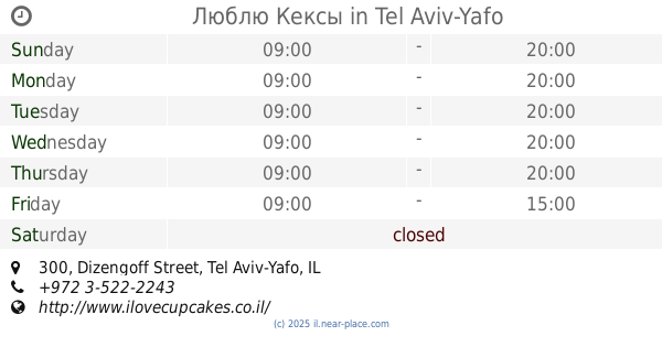
Люблю Кексы
Dizengoff Street 300, Tel Aviv-Yafo
Bakery
read more
1.894 km
בייקרי ככר המדינה - Bakery
ויצמן 67, תל אביב יפו
Bakery
read more
1.953 km
לחם תושיה
בזל 44, תל אביב יפו
Bakery
read more
1.994 km
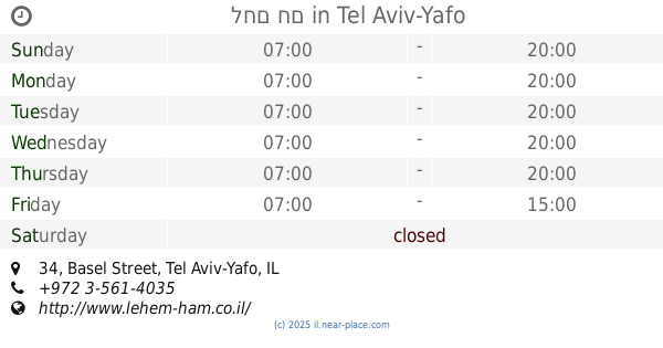
לחם חם
Basel Street 34, Tel Aviv-Yafo
Bakery
read more
2.419 km
Дом Хлеба
Dizengoff Street 203, Tel Aviv-Yafo
Bakery
read more
📑
all categories
Accounting
Administrative area level 1
Administrative area level 2
Airport
Amusement park
Aquarium
Art gallery
Atm
Bakery
Bank
Bar
Beauty salon
Bicycle store
Book store
Bowling alley
Bus station
Cafe
Campground
Car dealer
Car rental
Car repair
Car wash
Casino
Cemetery
Church
City hall
Clothing store
Colloquial area
Convenience store
Country
Courthouse
Dentist
Department store
Doctor
Electrician
Electronics store
Embassy
Establishment
Finance
Fire station
Florist
Food
Funeral home
Furniture store
Gas station
General contractor
Grocery or supermarket
Gym
Hair care
Hardware store
Health
Hindu Temple
Home goods store
Hospital
Insurance agency
Intersection
Jewelry store
Laundry
Lawyer
Library
Light rail station
Liquor store
Local government office
Locality
Locksmith
Lodging
Meal delivery
Meal takeaway
Mosque
Movie rental
Movie theater
Moving company
Museum
Natural feature
Neighborhood
Night club
Painter
Park
Parking
Pet store
Pharmacy
Physiotherapist
Place of worship
Plumber
Point of interest
Police
Political
Post office
Premise
Real estate agency
Restaurant
Roofing contractor
Route
Rv park, camping
School
Shoe store
Shopping mall
Spa
Stadium
Storage
Store
Subpremise
Subway station
Supermarket
Synagogue
Taxi stand
Train station
Transit station
Travel agency
University
Veterinary care
Zoo
administrative area level 3
administrative area level 4
sublocality level 1
↑