Airport nearby Megido Airport
Israel
Airport nearby Megido Airport
Megido Airport
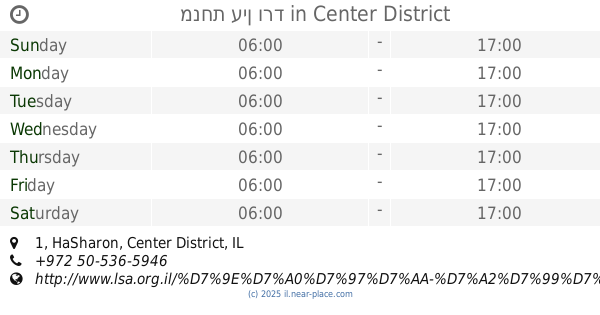
כביש 65, עפולה, יזרעאל, IL Израиль
contacts phone
:
+972 4-652-8847
website:
www.megido-air.co.il
Latitude:
32.5949674
, Longitude:
35.2366502
larger map & directions
read more
nearest Airport
10.93 km
גן התעשייה נצרת עלית
Nazareth
Airport
read more
27.565 km
Ein Shemer Airfield
2
Airport
read more
27.565 km
מנחת עין שמר
2
Airport
read more
29.084 km
Ha Bonim Airfield
Israel
Airport
read more
29.084 km
Ha Bonim Airfield
Израиль
Airport
read more
29.084 km
Ha Bonim Airfield
Izrael
Airport
read more
29.252 km
שער בסיס חיל האויר בחא 21 חיפה
Derech Yigael Yadin, Haifa
Airport
read more
30.283 km
Flughafen Haifa Michaelli
Yulius Simon Street, Haifa
Airport
read more
30.283 km
Хайфский Аэропорт имени Михаэли
Yulius Simon Street, Haifa
Airport
read more
30.283 km
Haifa Airport
Yulius Simon Street, Haifa
Airport
read more
32.498 km
Regulus Cyber Area 51
Israel
Airport
read more
35.555 km
Rambam Helicopters Airfield
Haifa
Airport
read more
39.976 km
מנחת תנובות
Israel
Airport
read more
45.556 km
מנחת עין ורד
32°15'49. 34°57'03., 1
Airport
read more
45.594 km
בקאי ישראל
מנחת עין ורד, Ein Vered
Airport
read more
45.594 km
בקאי ישראל
מנחת עין ורד, עין ורד
Airport
read more
45.844 km
שור מור
עמנואל מול 18 זלבל, Netanya
Airport
read more
58.511 km
מנחת טיסנים ארסוף
ארסוף
Airport
read more
59.66 km
Skiitrif | SkyTrip - flight training and flight experience
מנחם בגין שדה התעופה, Herzliya
Airport
read more
59.66 km
Skiitrif | SkyTrip - flight training and flight experience
שדה התעופה הרצליה, Herzliya
Airport
read more
59.66 km
סקייטריפ | SkyTrip הדרכת טיסה וטיסות חוויה בשמי הארץ
מנחם בגין שדה התעופה, הרצליה
Airport
read more
59.91 km
ב. סקאי שרותי תעופה בעמ
שדה תעופה, הרצליה
Airport
read more
59.91 km
B. Sky Aviation Services Ltd.
שדה תעופה, Herzliya
Airport
read more
📑
all categories
Accounting
Administrative area level 1
Administrative area level 2
Airport
Amusement park
Aquarium
Art gallery
Atm
Bakery
Bank
Bar
Beauty salon
Bicycle store
Book store
Bowling alley
Bus station
Cafe
Campground
Car dealer
Car rental
Car repair
Car wash
Casino
Cemetery
Church
City hall
Clothing store
Colloquial area
Convenience store
Country
Courthouse
Dentist
Department store
Doctor
Electrician
Electronics store
Embassy
Establishment
Finance
Fire station
Florist
Food
Funeral home
Furniture store
Gas station
General contractor
Grocery or supermarket
Gym
Hair care
Hardware store
Health
Hindu Temple
Home goods store
Hospital
Insurance agency
Intersection
Jewelry store
Laundry
Lawyer
Library
Light rail station
Liquor store
Local government office
Locality
Locksmith
Lodging
Meal delivery
Meal takeaway
Mosque
Movie rental
Movie theater
Moving company
Museum
Natural feature
Neighborhood
Night club
Painter
Park
Parking
Pet store
Pharmacy
Physiotherapist
Place of worship
Plumber
Point of interest
Police
Political
Post office
Premise
Real estate agency
Restaurant
Roofing contractor
Route
Rv park, camping
School
Shoe store
Shopping mall
Spa
Stadium
Storage
Store
Subpremise
Subway station
Supermarket
Synagogue
Taxi stand
Train station
Transit station
Travel agency
University
Veterinary care
Zoo
administrative area level 3
administrative area level 4
sublocality level 1
↑