University nearby The Open University Eilat Branch
Israel
University nearby The Open University Eilat Branch
The Open University Eilat Branch
Эйлат, Израиль
contacts phone
:
+972
Latitude:
29.5547461
, Longitude:
34.9494855
larger map & directions
read more
nearest University
16 m
Колледж Левински Эдьюкейшен
Eilat
University
read more
16 m
Levinski Education College
Eilat
University
read more
18 m
College of Management
Sderot Hativat HaNegev 3, Eilat
University
read more
417 m
מישל מאייר-מכללה ליופי
Sderot HaTmarim 1, Eilat
University
read more
481 m
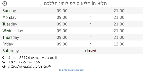
מכללת ניהול פלוס אילת
אילת, פתן 4, אילת
University
read more
481 m
Friedman College Campus Eilat in cooperation with Management Plus
Peten Street 4, Eilat
University
read more
1.259 km
מכללת אילת
חניתן 4, אילת
University
read more
1.339 km
Computing Manager
Eilat
University
read more
1.339 km
רכזת בחינות
אילת
University
read more
1.339 km
Exams Coordinator
Eilat
University
read more
1.339 km
רכז אנגלית
אילת
University
read more
1.339 km
הנהח
אילת
University
read more
1.34 km
Student Union
Eilat
University
read more
1.34 km
פרח
אילת
University
read more
1.34 km
מרכז פיסגה
אילת
University
read more
1.34 km
אגודת הסטודנטים
אילת
University
read more
1.34 km
Professors' Offices
Eilat
University
read more
1.34 km
שרותי ייעוץ לסטודנט
אילת
University
read more
1.364 km
מרכז העשרה פרח
אילת
University
read more
1.364 km
Research Lab for Marine Biology and Biotechnology
Eilat
University
read more
1.364 km
מעבדת מחקר לביולוגיה וביוטכנולוגיה ימית
אילת
University
read more
1.421 km
אוניברסיטת בן-גוריון באילת
שדרות התמרים 162, אילת
University
read more
1.427 km
ספריה
אילת
University
read more
1.427 km
משרדי הנהלה
אילת
University
read more
1.507 km
Student Dormitories
Eilat
University
read more
📑
all categories
Accounting
Administrative area level 1
Administrative area level 2
Airport
Amusement park
Aquarium
Art gallery
Atm
Bakery
Bank
Bar
Beauty salon
Bicycle store
Book store
Bowling alley
Bus station
Cafe
Campground
Car dealer
Car rental
Car repair
Car wash
Casino
Cemetery
Church
City hall
Clothing store
Colloquial area
Convenience store
Country
Courthouse
Dentist
Department store
Doctor
Electrician
Electronics store
Embassy
Establishment
Finance
Fire station
Florist
Food
Funeral home
Furniture store
Gas station
General contractor
Grocery or supermarket
Gym
Hair care
Hardware store
Health
Hindu Temple
Home goods store
Hospital
Insurance agency
Intersection
Jewelry store
Laundry
Lawyer
Library
Light rail station
Liquor store
Local government office
Locality
Locksmith
Lodging
Meal delivery
Meal takeaway
Mosque
Movie rental
Movie theater
Moving company
Museum
Natural feature
Neighborhood
Night club
Painter
Park
Parking
Pet store
Pharmacy
Physiotherapist
Place of worship
Plumber
Point of interest
Police
Political
Post office
Premise
Real estate agency
Restaurant
Roofing contractor
Route
Rv park, camping
School
Shoe store
Shopping mall
Spa
Stadium
Storage
Store
Subpremise
Subway station
Supermarket
Synagogue
Taxi stand
Train station
Transit station
Travel agency
University
Veterinary care
Zoo
administrative area level 3
administrative area level 4
sublocality level 1
↑