University nearby מגרש כדורסל
Israel
University nearby מגרש כדורסל
מגרש כדורסל
118, Kfar Aviv, Израиль
contacts phone
:
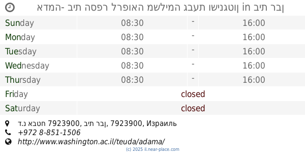
+972
Latitude:
31.830827
, Longitude:
34.7226578
larger map & directions
read more
nearest University
1.529 km
School for Music
Israel
University
read more
1.532 km
מכללה אקדמית לחינוך גבעת וושינגטון
Israel
University
read more
1.532 km
College of Education Givat Washington
Israel
University
read more
1.614 km
אולפנה
Israel
University
read more
1.614 km
Ulpena
Israel
University
read more
1.645 km
קרית חינוך גבעת ושינגטון
Israel
University
read more
1.645 km
Givat Washington Educational Campus
Israel
University
read more
1.661 km
אדמה- בית הספר לרפואה משלימה גבעת ושינגטון
ד.נ אבטח 7923900, בית רבן
University
read more
1.665 km
College
Israel
University
read more
1.714 km
Beit Raban Secretariat
Israel
University
read more
1.714 km
מזכירות בית רבן
Israel
University
read more
4.522 km
פיבראוס ישראל PhiBrows Israel
דרך קנדה 41/1, גן יבנה
University
read more
4.522 km
פיבראוס ישראל PhiBrows Israel
Derech Canada 41/1, Gan Yavne
University
read more
6.301 km
Ya'ad College
Aschdod
University
read more
8.32 km
קבוצת גישות למצויינות
הכישור 2, רחובות
University
read more
9.054 km
Йога в Ашдоде
מפקורה, אשדוד
University
read more
10.54 km
מכללת רחובות האוניברסיטה הפתוחה
גיבורי ישראל 2, רחובות
University
read more
10.795 km
תואר ראשון במדעי ההתנהגות
Israel
University
read more
11.352 km
חממות
רחובות
University
read more
11.882 km
Dean Department of Biological Regulation
רחובות
University
read more
11.883 km
Department of Biological Regulation
רחובות
University
read more
12.184 km
Domestic Procurment Branch
Rehovot
University
read more
12.245 km
Department of Physics of Complex Systems
Rehovot
University
read more
12.265 km
Faculty of Physics
רחובות
University
read more
15.067 km
הזדמהות שנייה בשיווק ישיר וחברתי
קיבוץ ניצנים ניצנים IL 7929000, ניצנים
University
read more
📑
all categories
Accounting
Administrative area level 1
Administrative area level 2
Airport
Amusement park
Aquarium
Art gallery
Atm
Bakery
Bank
Bar
Beauty salon
Bicycle store
Book store
Bowling alley
Bus station
Cafe
Campground
Car dealer
Car rental
Car repair
Car wash
Casino
Cemetery
Church
City hall
Clothing store
Colloquial area
Convenience store
Country
Courthouse
Dentist
Department store
Doctor
Electrician
Electronics store
Embassy
Establishment
Finance
Fire station
Florist
Food
Funeral home
Furniture store
Gas station
General contractor
Grocery or supermarket
Gym
Hair care
Hardware store
Health
Hindu Temple
Home goods store
Hospital
Insurance agency
Intersection
Jewelry store
Laundry
Lawyer
Library
Light rail station
Liquor store
Local government office
Locality
Locksmith
Lodging
Meal delivery
Meal takeaway
Mosque
Movie rental
Movie theater
Moving company
Museum
Natural feature
Neighborhood
Night club
Painter
Park
Parking
Pet store
Pharmacy
Physiotherapist
Place of worship
Plumber
Point of interest
Police
Political
Post office
Premise
Real estate agency
Restaurant
Roofing contractor
Route
Rv park, camping
School
Shoe store
Shopping mall
Spa
Stadium
Storage
Store
Subpremise
Subway station
Supermarket
Synagogue
Taxi stand
Train station
Transit station
Travel agency
University
Veterinary care
Zoo
administrative area level 3
administrative area level 4
sublocality level 1
↑