Synagogue nearby Synagogue Tiferet Rafael
Israel
Synagogue nearby Synagogue Tiferet Rafael
Synagogue Tiferet Rafael
HaMa'avak Street, Ashdod, Ashkelon, IL Israel
contacts phone
:
+972
Latitude:
31.7839685
, Longitude:
34.6427599
larger map & directions
read more
nearest Synagogue
331 m
בית הכנסת אור יצחק
אשדוד
Synagogue
read more
351 m
Synagogue 'with tribes of Israel
Kakal Street 17, Ashdod
Synagogue
read more
359 m
בית כנסת רובע הסיטי
אשדוד
Synagogue
read more
359 m
בית כנסת רובע הסיטי
Ashdod
Synagogue
read more
421 m
נס לישראל בית כנסת
אשדוד
Synagogue
read more
458 m
בית כנסת הקראי כתר תורה אשדוד
Tishrei Street 90, Ashdod
Synagogue
read more
487 m
Beit Midrash Mishkanot Shmuel
Ashdod
Synagogue
read more
487 m
בית מדרש משכנות שמואל
אשדוד
Synagogue
read more
587 m
The Ashdod City Menachem Chabad synagogue
Ha-Atsma'ut Street 93, Ashdod
Synagogue
read more
668 m
Porat Yosef Synagogue
Ashdod
Synagogue
read more
673 m
בית כנסת אור החיים הקדוש
Ashdod
Synagogue
read more
701 m
בית הכנסת הפתוח חב"ד
דוד המלך 13, אשדוד
Synagogue
read more
819 m
בית חבד רובע הקריה, אשדוד
תחנה מרכזית, שדרות מנחם בגין 1, אשדוד
Synagogue
read more
819 m
Chabad Center - The Kirya Quarter, Ashdod
תחנה מרכזית, שדרות מנחם בגין 1, אשדוד
Synagogue
read more
833 m
Shalom Shabzi Synagogue
Nahal Snir Street 5, Ashdod
Synagogue
read more
835 m
בית כנסת אחוות ישראל
אשדוד
Synagogue
read more
863 m
בית כנסת זכרון אברהם
אשדוד
Synagogue
read more
863 m
בית כנסת זכרון אברהם
Ashdod
Synagogue
read more
879 m
Synagogue Congregation new song
Ashdod
Synagogue
read more
916 m
Synagogue Siah Yitzhak
HaYasmin Street 3, Ashdod
Synagogue
read more
945 m
בית כנסת משכן מאיר
אשדוד
Synagogue
read more
950 m
בית כנסת פרלמן
היסמין 1, אשדוד
Synagogue
read more
982 m
היכל דב - אולם גראנס
הרותם 35, אשדוד
Synagogue
read more
1.032 km
בית המדרש מעליץ
Ashdod
Synagogue
read more
1.044 km
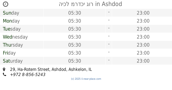
היכל מרדכי גור
Ha-Rotem Street 29, Ashdod
Synagogue
read more
📑
all categories
Accounting
Administrative area level 1
Administrative area level 2
Airport
Amusement park
Aquarium
Art gallery
Atm
Bakery
Bank
Bar
Beauty salon
Bicycle store
Book store
Bowling alley
Bus station
Cafe
Campground
Car dealer
Car rental
Car repair
Car wash
Casino
Cemetery
Church
City hall
Clothing store
Colloquial area
Convenience store
Country
Courthouse
Dentist
Department store
Doctor
Electrician
Electronics store
Embassy
Establishment
Finance
Fire station
Florist
Food
Funeral home
Furniture store
Gas station
General contractor
Grocery or supermarket
Gym
Hair care
Hardware store
Health
Hindu Temple
Home goods store
Hospital
Insurance agency
Intersection
Jewelry store
Laundry
Lawyer
Library
Light rail station
Liquor store
Local government office
Locality
Locksmith
Lodging
Meal delivery
Meal takeaway
Mosque
Movie rental
Movie theater
Moving company
Museum
Natural feature
Neighborhood
Night club
Painter
Park
Parking
Pet store
Pharmacy
Physiotherapist
Place of worship
Plumber
Point of interest
Police
Political
Post office
Premise
Real estate agency
Restaurant
Roofing contractor
Route
Rv park, camping
School
Shoe store
Shopping mall
Spa
Stadium
Storage
Store
Subpremise
Subway station
Supermarket
Synagogue
Taxi stand
Train station
Transit station
Travel agency
University
Veterinary care
Zoo
administrative area level 3
administrative area level 4
sublocality level 1
↑