Synagogue nearby Synagogue crown of our heads
Israel
Synagogue nearby Synagogue crown of our heads
Synagogue crown of our heads
Тверия, Израиль
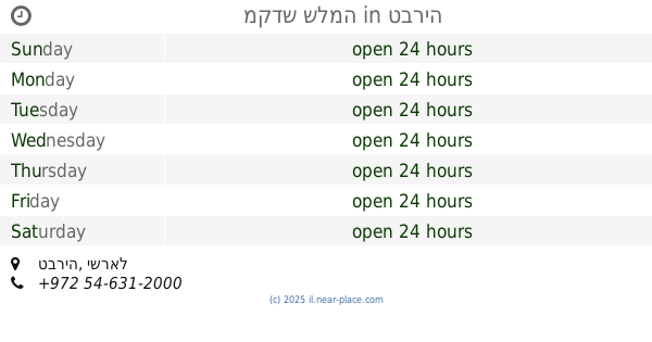
contacts phone
:
+972
Latitude:
32.780075
, Longitude:
35.5124673
larger map & directions
read more
nearest Synagogue
227 m
בית המדרש ווילעדניק
הנשיא וייצמן 14, טבריה
Synagogue
read more
268 m
בית כנסת חניכי הישיבות
Tiberias
Synagogue
read more
293 m
The synagogue and study hall conference members
Jabotinski Street 3, Tiberias
Synagogue
read more
301 m
אם הבנים
טבריה
Synagogue
read more
312 m
בית כנסת -לוי
David Elazar Street 9-15, Tiberias
Synagogue
read more
332 m
בית הכנסת קארלין סטאלין
יצחק בן צבי 24-28, טבריה
Synagogue
read more
336 m
כולל אברכים - תורת חסד-סלאנים
שז"ר 6, טבריה
Synagogue
read more
336 m
תורת חסד סלאנים
שז"ר 6, טבריה
Synagogue
read more
336 m
תורת חסד סאנים
שז"ר 6, טבריה
Synagogue
read more
336 m
כולל אברכים - תורת חסד-סלאנים
Shazar Street 6, Tiberias
Synagogue
read more
340 m
בית הכנסת ומרכז רוחני סטאלין קארלין
Or Haim Street 24-28, Tiberias
Synagogue
read more
346 m
בית המדרש ליזענסק
דוד אלעזר 15, טבריה
Synagogue
read more
346 m
Beit Midrash Lizansk
David Elazar Street 15, Tiberias
Synagogue
read more
394 m
בית המדרש המרכזי קהילות החסידים
Shazar Street 1119-1120, Tiberias
Synagogue
read more
416 m
Synagogue theory of life
Tiberias
Synagogue
read more
432 m
בית חבד טבריה עלית
אור חיים 16, טבריה
Synagogue
read more
444 m
בית כנסת בית יוסף
Ben Eli'ezer Street 1119-1120, Tiberias
Synagogue
read more
575 m
ביהמ''ד דחסידי צאנז
Tiberias
Synagogue
read more
640 m
מקדש שלמה
טבריה
Synagogue
read more
658 m
אדמור מליזענסק
שז"ר, טבריה
Synagogue
read more
771 m
בית מנחם
Yefe Nof Street, Tiberias
Synagogue
read more
943 m
בית כנסת גיבורי ישראל
טבריה
Synagogue
read more
946 m
בית הכנסת שירה לדוד שלום
טבריה
Synagogue
read more
1.305 km
בית הכנסת כינור יוסף
Ha-Dekel Street 431, Tiberias
Synagogue
read more
1.305 km
בית הכנסת כינור יוסף
הדקל 431, טבריה
Synagogue
read more
📑
all categories
Accounting
Administrative area level 1
Administrative area level 2
Airport
Amusement park
Aquarium
Art gallery
Atm
Bakery
Bank
Bar
Beauty salon
Bicycle store
Book store
Bowling alley
Bus station
Cafe
Campground
Car dealer
Car rental
Car repair
Car wash
Casino
Cemetery
Church
City hall
Clothing store
Colloquial area
Convenience store
Country
Courthouse
Dentist
Department store
Doctor
Electrician
Electronics store
Embassy
Establishment
Finance
Fire station
Florist
Food
Funeral home
Furniture store
Gas station
General contractor
Grocery or supermarket
Gym
Hair care
Hardware store
Health
Hindu Temple
Home goods store
Hospital
Insurance agency
Intersection
Jewelry store
Laundry
Lawyer
Library
Light rail station
Liquor store
Local government office
Locality
Locksmith
Lodging
Meal delivery
Meal takeaway
Mosque
Movie rental
Movie theater
Moving company
Museum
Natural feature
Neighborhood
Night club
Painter
Park
Parking
Pet store
Pharmacy
Physiotherapist
Place of worship
Plumber
Point of interest
Police
Political
Post office
Premise
Real estate agency
Restaurant
Roofing contractor
Route
Rv park, camping
School
Shoe store
Shopping mall
Spa
Stadium
Storage
Store
Subpremise
Subway station
Supermarket
Synagogue
Taxi stand
Train station
Transit station
Travel agency
University
Veterinary care
Zoo
administrative area level 3
administrative area level 4
sublocality level 1
↑