Synagogue nearby קבר חולדה הנביאה
Israel
Synagogue nearby קבר חולדה הנביאה
קבר חולדה הנביאה
ירושלים
contacts phone
:
+972
Latitude:
31.7788885
, Longitude:
35.2450607
larger map & directions
read more
nearest Synagogue
478 m
Hakutover Tomb
Jerusalem
Synagogue
read more
478 m
קבר הקיטובער
ירושלים
Synagogue
read more
488 m
קבר הארי
ירושלים
Synagogue
read more
1.258 km
ביכ חסידי ברסלב
ירושלים
Synagogue
read more
1.264 km
ביכ ניסן בק הרוס
ירושלים
Synagogue
read more
1.318 km
Synagogue Rabbi David Ben Shimon
Jerusalem
Synagogue
read more
1.351 km
ביכ בית אל מקובלים
ירושלים
Synagogue
read more
1.362 km
בית הכנסת האמצעי
ירושלים
Synagogue
read more
1.366 km
Four Sephardic Synagogues
Иерусалим
Synagogue
read more
1.37 km
Eliyahu HaNavi Synagogue
Иерусалим
Synagogue
read more
1.371 km
ארבעת בתי הכנסת הספרדים ריבז
ירושלים
Synagogue
read more
1.371 km
בית כנסת החורבה
היהודים, ירושלים
Synagogue
read more
1.403 km
בית הכנסת הצמח צדק
חב"ד, ירושלים
Synagogue
read more
1.43 km
Yirmiyahu Tomb
Jerusalem
Synagogue
read more
1.461 km
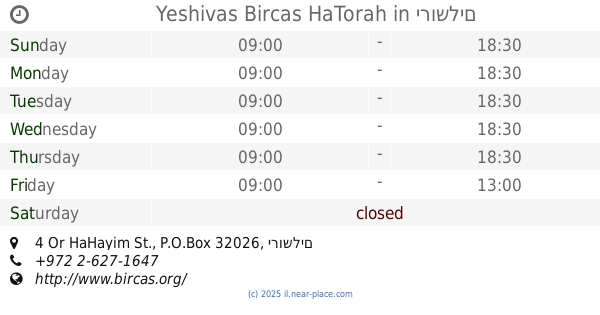
Yeshivas Bircas HaTorah
4 Or HaHayim St., P.O.Box 32026, ירושלים
Synagogue
read more
1.472 km
Hecht Synagogue
Jerusalem
Synagogue
read more
1.958 km
Synagogue Safra
ירושלים
Synagogue
read more
2.105 km
בית הכנסת הגדול, ברסלב ירושלים
הרב שמואל סלנט 36, ירושלים
Synagogue
read more
2.184 km
Spread Scholl
Moshe ve-Ester Lezer Street 2-18, Jerusalem
Synagogue
read more
2.184 km
פרושים שול
משה ואסתר לעזער 2-18, ירושלים
Synagogue
read more
2.302 km
בית כנסת קרני
Shim'on Rokah Street 54, Jerusalem
Synagogue
read more
2.326 km
בית הכנסת ארזי הבירה
ארזי הבירה 47, ירושלים
Synagogue
read more
2.349 km
Ahavat Shalom Beit Midrash
Petahia Street 11, Jerusalem
Synagogue
read more
2.493 km
היכל התורה ומקווה דושינסקיא
יהויריב 3, ירושלים
Synagogue
read more
2.493 km
היכל התורה ומקווה דושינסקיא
Yehoyariv Street 3, Jerusalem
Synagogue
read more
📑
all categories
Accounting
Administrative area level 1
Administrative area level 2
Airport
Amusement park
Aquarium
Art gallery
Atm
Bakery
Bank
Bar
Beauty salon
Bicycle store
Book store
Bowling alley
Bus station
Cafe
Campground
Car dealer
Car rental
Car repair
Car wash
Casino
Cemetery
Church
City hall
Clothing store
Colloquial area
Convenience store
Country
Courthouse
Dentist
Department store
Doctor
Electrician
Electronics store
Embassy
Establishment
Finance
Fire station
Florist
Food
Funeral home
Furniture store
Gas station
General contractor
Grocery or supermarket
Gym
Hair care
Hardware store
Health
Hindu Temple
Home goods store
Hospital
Insurance agency
Intersection
Jewelry store
Laundry
Lawyer
Library
Light rail station
Liquor store
Local government office
Locality
Locksmith
Lodging
Meal delivery
Meal takeaway
Mosque
Movie rental
Movie theater
Moving company
Museum
Natural feature
Neighborhood
Night club
Painter
Park
Parking
Pet store
Pharmacy
Physiotherapist
Place of worship
Plumber
Point of interest
Police
Political
Post office
Premise
Real estate agency
Restaurant
Roofing contractor
Route
Rv park, camping
School
Shoe store
Shopping mall
Spa
Stadium
Storage
Store
Subpremise
Subway station
Supermarket
Synagogue
Taxi stand
Train station
Transit station
Travel agency
University
Veterinary care
Zoo
administrative area level 3
administrative area level 4
sublocality level 1
↑