Synagogue nearby מרכז קהילת הפארק. בית הכנסת שירת ציון.
Israel
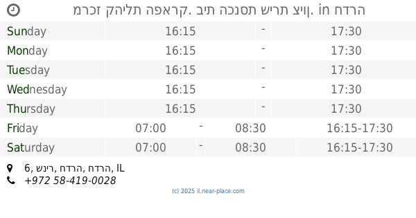
Synagogue nearby מרכז קהילת הפארק. בית הכנסת שירת ציון.
מרכז קהילת הפארק. בית הכנסת שירת ציון.
6, Snir Street, Hadera, Hadera, IL Израиль
contacts phone
:
+972 58-419-0028
Latitude:
32.4304421
, Longitude:
34.9324405
larger map & directions
read more
nearest Synagogue
מרכז קהילת הפארק. בית הכנסת שירת ציון.
שניר 6, חדרה
Synagogue
read more
699 m
בית הכנסת ששת הימים יוספטל
חדרה
Synagogue
read more
699 m
Six days synagogue Yoseftal
Hadera
Synagogue
read more
837 m
Halloween Memory Synagogue
Hadera
Synagogue
read more
856 m
בית הכנסת שכונת אפרים
חדרה
Synagogue
read more
856 m
Ephraim neighborhood synagogue
Hadera
Synagogue
read more
916 m
בית כנסת אור אל
Herbert Samuel Street 99, Hadera
Synagogue
read more
916 m
בית כנסת אור אל
הרברט סמואל 99, חדרה
Synagogue
read more
1.086 km
בית כנסת ספרדי ניסן
פיינברג, חדרה
Synagogue
read more
1.086 km
Sephardic Synagogue
רחוב פיינברג, חדרה
Synagogue
read more
1.086 km
Sephardic Synagogue
Feinberg Street, Hadera
Synagogue
read more
1.101 km
חבד חדרה
38224, הגיבורים 68, חדרה
Synagogue
read more
1.101 km
Chabad of Hadera
38224, HaGiborim Street 68, Hadera
Synagogue
read more
1.107 km
Chabad of Hadera
HaGiborim Street 68, Hadera
Synagogue
read more
1.132 km
ביכ הגדול
חדרה
Synagogue
read more
1.132 km
Great Synagogue
Hadera
Synagogue
read more
1.617 km
Etsyon Hall Synagogue
Hadera
Synagogue
read more
1.66 km
בית כנסת עץ החיים
Yitshak Ben Zvi Street 2-6, Hadera
Synagogue
read more
1.716 km
בית הכנסת היכל יוסף
Hadera
Synagogue
read more
1.975 km
Spanish Synagogue Neve Shalom Hadera
Hadera
Synagogue
read more
2.001 km
Yeshivat Ha-Ramkhal
Al Kanfei Nesharim Street 4, Hadera
Synagogue
read more
2.006 km
שטיבלאך היכל שמואל
Hadera
Synagogue
read more
2.006 km
שטיבלאך "היכל שמואל"
חדרה
Synagogue
read more
2.642 km
בית הכנסת האשכנזי בית אליעזר
וילנסקי 8, חדרה
Synagogue
read more
2.642 km
בית הכנסת האשכנזי בית אליעזר
Wilensky Street 8, Hadera
Synagogue
read more
📑
all categories
Accounting
Administrative area level 1
Administrative area level 2
Airport
Amusement park
Aquarium
Art gallery
Atm
Bakery
Bank
Bar
Beauty salon
Bicycle store
Book store
Bowling alley
Bus station
Cafe
Campground
Car dealer
Car rental
Car repair
Car wash
Casino
Cemetery
Church
City hall
Clothing store
Colloquial area
Convenience store
Country
Courthouse
Dentist
Department store
Doctor
Electrician
Electronics store
Embassy
Establishment
Finance
Fire station
Florist
Food
Funeral home
Furniture store
Gas station
General contractor
Grocery or supermarket
Gym
Hair care
Hardware store
Health
Hindu Temple
Home goods store
Hospital
Insurance agency
Intersection
Jewelry store
Laundry
Lawyer
Library
Light rail station
Liquor store
Local government office
Locality
Locksmith
Lodging
Meal delivery
Meal takeaway
Mosque
Movie rental
Movie theater
Moving company
Museum
Natural feature
Neighborhood
Night club
Painter
Park
Parking
Pet store
Pharmacy
Physiotherapist
Place of worship
Plumber
Point of interest
Police
Political
Post office
Premise
Real estate agency
Restaurant
Roofing contractor
Route
Rv park, camping
School
Shoe store
Shopping mall
Spa
Stadium
Storage
Store
Subpremise
Subway station
Supermarket
Synagogue
Taxi stand
Train station
Transit station
Travel agency
University
Veterinary care
Zoo
administrative area level 3
administrative area level 4
sublocality level 1
↑