Synagogue nearby מקדש מלך
Coronavirus disease (COVID-19) Situation
confirmed cases
4841772
deaths
12707
Israel
Synagogue nearby מקדש מלך
מקדש מלך
93, העצמאות, הרצליה, IL ישראל
contacts phone
:
+972
Latitude:
32.1650843
, Longitude:
34.8496135
larger map & directions
read more
nearest Synagogue
מקדש מלך
HaAtsmaut Street 93, Herzliya
Synagogue
read more
65 m
בית הכנסת הספרדי המרכזי
הרצליה
Synagogue
read more
65 m
Sepharadi Central Synagogue
Herzliya
Synagogue
read more
193 m
Agudas Achim Synagogue
HaAtsmaut Street 78, Herzliya
Synagogue
read more
193 m
בית כנסת אגודת אחים
העצמאות 78, הרצליה
Synagogue
read more
199 m
Achdut Synagogue
Ha-Kuzari Street 3, Herzliya
Synagogue
read more
199 m
בית כנסת אחדות
הכוזרי 3, הרצליה
Synagogue
read more
547 m
Binding of Isaac
HaGalil Street 9, Herzliya
Synagogue
read more
547 m
עקדת יצחק
הגליל 9, הרצליה
Synagogue
read more
604 m
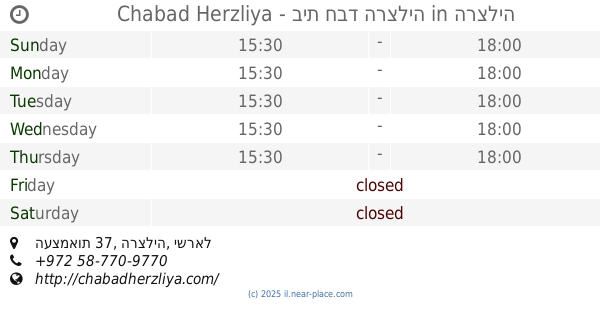
Chabad - Lubavitch Herzliya
העצמאות 37, Herzliya
Synagogue
read more
604 m
Chabad Herzliya - בית חבד הרצליה
העצמאות 37, הרצליה
Synagogue
read more
626 m
Great Synagogue
Sokolov Street, Herzliya
Synagogue
read more
626 m
Great Synagogue
סוקולוב פינת Ben Gurion Blvd, Herzliya
Synagogue
read more
626 m
בי"כ הגדול
סוקולוב פינת Ben Gurion Blvd, הרצליה
Synagogue
read more
667 m
בית כנסת המרכזי נוה עמל
Berel Katzenelson Street 11, Herzliya
Synagogue
read more
977 m
בית הכנסת גאולת ישראל
מולדת 14, הרצליה
Synagogue
read more
977 m
בית הכנסת גאולת ישראל
Moledet Street 14, Herzliya
Synagogue
read more
977 m
Geulat Israel Synagogue
Moledet Street 14, Herzliya
Synagogue
read more
1.083 km
בית הכנסת בית הלוי
4620713, הפרטיזנים 32, הרצליה
Synagogue
read more
1.083 km
בית הכנסת בית הלוי
4620713, HaPartizanim Street 32, Herzliya
Synagogue
read more
1.083 km
Synagogue - Beit Halevi
4620713, HaPartizanim Street 32, Herzliya
Synagogue
read more
1.091 km
בית כנסת תפארת בחורים
Gissin Street 6, Herzliya
Synagogue
read more
1.091 km
בית כנסת תפארת בחורים
גיסין 6, הרצליה
Synagogue
read more
1.112 km
בית כנסת אור החיים
הרצליה
Synagogue
read more
1.208 km
Keter Torah Synagogue
Herzliya
Synagogue
read more
📑
all categories
Accounting
Administrative area level 1
Administrative area level 2
Airport
Amusement park
Aquarium
Art gallery
Atm
Bakery
Bank
Bar
Beauty salon
Bicycle store
Book store
Bowling alley
Bus station
Cafe
Campground
Car dealer
Car rental
Car repair
Car wash
Casino
Cemetery
Church
City hall
Clothing store
Colloquial area
Convenience store
Country
Courthouse
Dentist
Department store
Doctor
Electrician
Electronics store
Embassy
Establishment
Finance
Fire station
Florist
Food
Funeral home
Furniture store
Gas station
General contractor
Grocery or supermarket
Gym
Hair care
Hardware store
Health
Hindu Temple
Home goods store
Hospital
Insurance agency
Intersection
Jewelry store
Laundry
Lawyer
Library
Light rail station
Liquor store
Local government office
Locality
Locksmith
Lodging
Meal delivery
Meal takeaway
Mosque
Movie rental
Movie theater
Moving company
Museum
Natural feature
Neighborhood
Night club
Painter
Park
Parking
Pet store
Pharmacy
Physiotherapist
Place of worship
Plumber
Point of interest
Police
Political
Post office
Premise
Real estate agency
Restaurant
Roofing contractor
Route
Rv park, camping
School
Shoe store
Shopping mall
Spa
Stadium
Storage
Store
Subpremise
Subway station
Supermarket
Synagogue
Taxi stand
Train station
Transit station
Travel agency
University
Veterinary care
Zoo
administrative area level 3
administrative area level 4
sublocality level 1
↑