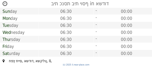
Synagogue nearby Mordichai Yehuda
Israel
Synagogue nearby Mordichai Yehuda
Mordichai Yehuda
Ashdod, Israel
contacts phone
:
+972 8-867-5852
Latitude:
31.7922887
, Longitude:
34.6651936
larger map & directions
read more
nearest Synagogue
152 m
מאקווא
אשדוד
Synagogue
read more
196 m
בית כנסת ובית הוראה מאורי אור
20, Rabi Yehuda ha-Nasi Street 16, Ashdod
Synagogue
read more
379 m
בית כנסת בית שלמה
אשדוד
Synagogue
read more
379 m
Shlomo Synagogue
Ashdod
Synagogue
read more
458 m
שטיבלאך - קהל חסידים
רבי אליעזר בן הורקנוס 7, אשדוד
Synagogue
read more
458 m
שטיבלאך - קהל חסידים
Rabbi Eliezer Ben Horkanos 7, Ashdod
Synagogue
read more
504 m
בית הכנסת המרכזי שמחת אליהו
אשדוד
Synagogue
read more
574 m
בית מדרש דושינסקיא
אשדוד
Synagogue
read more
583 m
חסידות טשרנוביל
Rabbi Yanai Street 34, Ashdod
Synagogue
read more
612 m
בית הכנסת גור בעל הנס
Rabi Me'ir Ba'al ha-Nes Street 8, Ashdod
Synagogue
read more
612 m
בית הכנסת גור בעל הנס
רבי מאיר בעל הנס 8, אשדוד
Synagogue
read more
771 m
בית כנסת אור החיים
אור חיים 9, אשדוד
Synagogue
read more
782 m
בית אליהו
אשדוד
Synagogue
read more
796 m
Ashdod Yeshiva Synagogue
Rabi Akiva Street 6, Ashdod
Synagogue
read more
827 m
מדרשייה לבנות לב יצחק
מיכשווילי 18, אשדוד
Synagogue
read more
847 m
בית הכנסת חבד
רבי עקיבא 4, אשדוד
Synagogue
read more
876 m
Synagogue gift Worlds
Ashdod
Synagogue
read more
876 m
בית כנסת שי עולמות
אשדוד
Synagogue
read more
897 m
בית כנסת אהבת ציון
אשדוד
Synagogue
read more
897 m
Ahavat Zion Synagogue
Ashdod
Synagogue
read more
920 m
בית כנסת אליהו הנביא
Dov Gur Street 24, Ashdod
Synagogue
read more
925 m
תפארת יהודה
Sderot Yerushalayim, Ashdod
Synagogue
read more
958 m
ישיבת פיטסבורג
צדקת יוסף 1, אשדוד
Synagogue
read more
969 m
בית כנסת בית יוסף
חפץ חיים, אשדוד
Synagogue
read more
969 m
בית כנסת בית יוסף
Khafets Khayim Street, Ashdod
Synagogue
read more
📑
all categories
Accounting
Administrative area level 1
Administrative area level 2
Airport
Amusement park
Aquarium
Art gallery
Atm
Bakery
Bank
Bar
Beauty salon
Bicycle store
Book store
Bowling alley
Bus station
Cafe
Campground
Car dealer
Car rental
Car repair
Car wash
Casino
Cemetery
Church
City hall
Clothing store
Colloquial area
Convenience store
Country
Courthouse
Dentist
Department store
Doctor
Electrician
Electronics store
Embassy
Establishment
Finance
Fire station
Florist
Food
Funeral home
Furniture store
Gas station
General contractor
Grocery or supermarket
Gym
Hair care
Hardware store
Health
Hindu Temple
Home goods store
Hospital
Insurance agency
Intersection
Jewelry store
Laundry
Lawyer
Library
Light rail station
Liquor store
Local government office
Locality
Locksmith
Lodging
Meal delivery
Meal takeaway
Mosque
Movie rental
Movie theater
Moving company
Museum
Natural feature
Neighborhood
Night club
Painter
Park
Parking
Pet store
Pharmacy
Physiotherapist
Place of worship
Plumber
Point of interest
Police
Political
Post office
Premise
Real estate agency
Restaurant
Roofing contractor
Route
Rv park, camping
School
Shoe store
Shopping mall
Spa
Stadium
Storage
Store
Subpremise
Subway station
Supermarket
Synagogue
Taxi stand
Train station
Transit station
Travel agency
University
Veterinary care
Zoo
administrative area level 3
administrative area level 4
sublocality level 1
↑