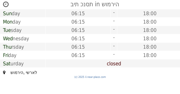
Synagogue nearby Central synagogue Bni Dklim
Israel
Synagogue nearby Central synagogue Bni Dklim
Central synagogue Bni Dklim
Bnei Dkalim, Israel
contacts phone
:
+972
Latitude:
31.5174255
, Longitude:
34.921256
larger map & directions
read more
nearest Synagogue
1.6 km
בית כנסת אוהל משה
Eliav
Synagogue
read more
1.6 km
בית כנסת אוהל משה
אליאב
Synagogue
read more
9.752 km
ביכ אל גטאר
אדורה
Synagogue
read more
10.057 km
בית כנסת
שומריה
Synagogue
read more
13.756 km
בית הכנסת המרכזי
No'am
Synagogue
read more
15.665 km
Synagogue
28, Shalva
Synagogue
read more
15.665 km
בית כנסת
28, שלווה
Synagogue
read more
17.07 km
בית הכנסת דוד בן ברוך הכהן
קרית גת
Synagogue
read more
17.613 km
בית כנסת היכל-ישראל
קרית גת
Synagogue
read more
17.819 km
Synagogue Neve Ezra Gbia
Mish'ol HaShoshan 69-77, Kiryat Gat
Synagogue
read more
17.869 km
משכן משה
שדרות גת 37, קרית גת
Synagogue
read more
17.881 km
Ovadia Yosef Synagogue
Kiryat Gat
Synagogue
read more
17.881 km
ביכ עובדיה יוסף
קרית גת
Synagogue
read more
17.965 km
Maimonides Synagogue
Kiryat Gat
Synagogue
read more
17.98 km
בית הכנסת תפארת ניצוצות
קרית גת
Synagogue
read more
17.98 km
Tif'eret Nitsotsot Synagogue
Kiryat Gat
Synagogue
read more
18.044 km
בית כנסת בית יעקב
משעול זבולון, קרית גת
Synagogue
read more
18.049 km
בית כנסת
Mish'ol Hairis, Kiryat Gat
Synagogue
read more
18.095 km
בית הכנסת עש הרב דרמר
Sderat Yehezkel 2, Kiryat Gat
Synagogue
read more
18.123 km
עקידת יצחק
קרית גת
Synagogue
read more
18.246 km
בית כנסת חבד המרכזי
Yermiyahu Street 11-13, Kiryat Gat
Synagogue
read more
18.246 km
בית כנסת חבד המרכזי
ירמיהו 11-13, קרית גת
Synagogue
read more
18.422 km
שערי ציון
Mish'ol Ehud Ben Gera 7, Kiryat Gat
Synagogue
read more
18.441 km
בית כנסת היכל שלמה
Mish'ol Ehud Ben Gera 9, Kiryat Gat
Synagogue
read more
18.441 km
בית כנסת היכל שלמה
משעול אהוד בן גרא 9, קרית גת
Synagogue
read more
📑
all categories
Accounting
Administrative area level 1
Administrative area level 2
Airport
Amusement park
Aquarium
Art gallery
Atm
Bakery
Bank
Bar
Beauty salon
Bicycle store
Book store
Bowling alley
Bus station
Cafe
Campground
Car dealer
Car rental
Car repair
Car wash
Casino
Cemetery
Church
City hall
Clothing store
Colloquial area
Convenience store
Country
Courthouse
Dentist
Department store
Doctor
Electrician
Electronics store
Embassy
Establishment
Finance
Fire station
Florist
Food
Funeral home
Furniture store
Gas station
General contractor
Grocery or supermarket
Gym
Hair care
Hardware store
Health
Hindu Temple
Home goods store
Hospital
Insurance agency
Intersection
Jewelry store
Laundry
Lawyer
Library
Light rail station
Liquor store
Local government office
Locality
Locksmith
Lodging
Meal delivery
Meal takeaway
Mosque
Movie rental
Movie theater
Moving company
Museum
Natural feature
Neighborhood
Night club
Painter
Park
Parking
Pet store
Pharmacy
Physiotherapist
Place of worship
Plumber
Point of interest
Police
Political
Post office
Premise
Real estate agency
Restaurant
Roofing contractor
Route
Rv park, camping
School
Shoe store
Shopping mall
Spa
Stadium
Storage
Store
Subpremise
Subway station
Supermarket
Synagogue
Taxi stand
Train station
Transit station
Travel agency
University
Veterinary care
Zoo
administrative area level 3
administrative area level 4
sublocality level 1
↑