Synagogue nearby בית הכנת בית אל גרבת-ידיר
Israel
Synagogue nearby בית הכנת בית אל גרבת-ידיר
בית הכנת בית אל גרבת-ידיר
שדה עוזיהו, ישראל
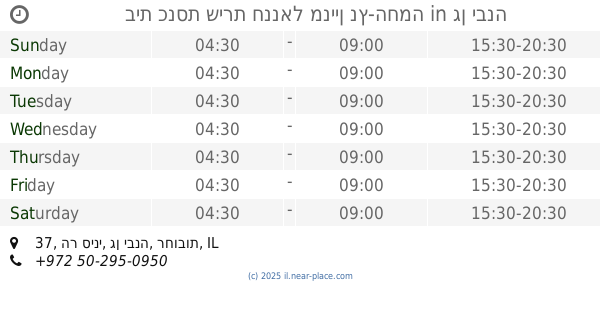
contacts phone
:
+972
Latitude:
31.7567679
, Longitude:
34.6773741
larger map & directions
read more
nearest Synagogue
The preparation of the house to-be keeping Eczema
Sde Uziyahu
Synagogue
read more
92 m
היכל ה'
Sde Uziyahu
Synagogue
read more
1.841 km
בית כנסת שערי שמים
שתולים
Synagogue
read more
1.841 km
Gates of Heaven Synagogue
Shtulim
Synagogue
read more
2.269 km
בית כנסת תפארת ישראל
שתולים
Synagogue
read more
2.269 km
בית כנסת תפארת ישראל
Shtulim
Synagogue
read more
2.342 km
Synagogue Shabazi (Anchor)
Ha-Rishonim Street 93, Shtulim
Synagogue
read more
3.095 km
Rashbi Synagogue
Gan Yavne
Synagogue
read more
3.233 km
Joseph protective synagogue
Ashdod
Synagogue
read more
3.325 km
בית כנסת אהל משה
Gan Yavne
Synagogue
read more
3.381 km
בית כנסת אהבת ישראל
Gan Yavne
Synagogue
read more
3.489 km
בית כנסת שירת חננאל מניין נץ-החמה
הר סיני 37, גן יבנה
Synagogue
read more
3.613 km
Hazon Ovadia synagogue
Gan Yavne
Synagogue
read more
3.629 km
Gan Yavne
גן יבנה
Synagogue
read more
3.669 km
בית כנסת משכן מאיר
אשדוד
Synagogue
read more
3.711 km
בית כנסת מגן אבות
גן יבנה
Synagogue
read more
3.711 km
Magen Avot Synagogue
Gan Yavne
Synagogue
read more
3.772 km
בית הכנסת אבא שלום שבזי
גן יבנה
Synagogue
read more
3.783 km
בית כנסת אור החיים הקדוש
Ashdod
Synagogue
read more
3.788 km
Ohel Tora Synagogue
Gan Yavne
Synagogue
read more
3.788 km
בית כנסת אוהל תורה
גן יבנה
Synagogue
read more
3.8 km
Porat Yosef Synagogue
Ashdod
Synagogue
read more
3.895 km
Or HaHaim Synagogue
Gan Yavne
Synagogue
read more
4.035 km
Ahavat Shalom Synagogue
Gan Yavne
Synagogue
read more
4.173 km
Synagogue 'with tribes of Israel
Kakal Street 17, Ashdod
Synagogue
read more
📑
all categories
Accounting
Administrative area level 1
Administrative area level 2
Airport
Amusement park
Aquarium
Art gallery
Atm
Bakery
Bank
Bar
Beauty salon
Bicycle store
Book store
Bowling alley
Bus station
Cafe
Campground
Car dealer
Car rental
Car repair
Car wash
Casino
Cemetery
Church
City hall
Clothing store
Colloquial area
Convenience store
Country
Courthouse
Dentist
Department store
Doctor
Electrician
Electronics store
Embassy
Establishment
Finance
Fire station
Florist
Food
Funeral home
Furniture store
Gas station
General contractor
Grocery or supermarket
Gym
Hair care
Hardware store
Health
Hindu Temple
Home goods store
Hospital
Insurance agency
Intersection
Jewelry store
Laundry
Lawyer
Library
Light rail station
Liquor store
Local government office
Locality
Locksmith
Lodging
Meal delivery
Meal takeaway
Mosque
Movie rental
Movie theater
Moving company
Museum
Natural feature
Neighborhood
Night club
Painter
Park
Parking
Pet store
Pharmacy
Physiotherapist
Place of worship
Plumber
Point of interest
Police
Political
Post office
Premise
Real estate agency
Restaurant
Roofing contractor
Route
Rv park, camping
School
Shoe store
Shopping mall
Spa
Stadium
Storage
Store
Subpremise
Subway station
Supermarket
Synagogue
Taxi stand
Train station
Transit station
Travel agency
University
Veterinary care
Zoo
administrative area level 3
administrative area level 4
sublocality level 1
↑