Synagogue nearby בית הכנסת ובא לציון גואל
Israel
Synagogue nearby בית הכנסת ובא לציון גואל
בית הכנסת ובא לציון גואל
Цфат, Израиль
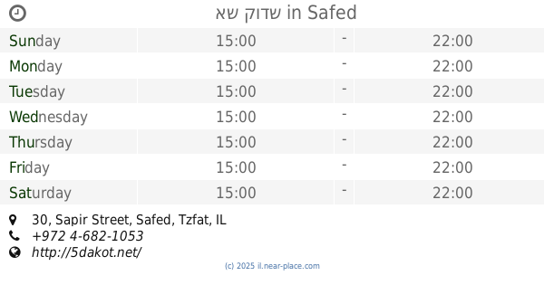
contacts phone
:
+972
Latitude:
32.9667281
, Longitude:
35.5120413
larger map & directions
read more
nearest Synagogue
בית הכנסת ובא לציון גואל
צפת
Synagogue
read more
337 m
אש קודש
Sapir Street 30, Safed
Synagogue
read more
371 m
בית כנסת אור תורה
צפת
Synagogue
read more
398 m
כלל אליאב אליהו
התבור 3, צפת
Synagogue
read more
398 m
כלל אליאב אליהו
Ha-Tavor Street 3, Safed
Synagogue
read more
458 m
בית כנסת חבד רמת רזים
HaHermon Street 531, Safed
Synagogue
read more
580 m
Synagogue named Baba Sali
Kaf Bet Yaldei Ma'alot Street 220, Safed
Synagogue
read more
580 m
בית כנסת ע״ש הבבא סאלי
כ"ב ילדי מעלות 220, צפת
Synagogue
read more
601 m
בית כנסת עש ר' חיי טייב
צפת
Synagogue
read more
601 m
בית כנסת עש ר' חיי טייב
Safed
Synagogue
read more
706 m
בית כנסת חב"ד, היכל לוי יצחק
Ha Rav Arie Leib Kaplan St. 1, צפת
Synagogue
read more
724 m
בית כנסת חבד
צפת
Synagogue
read more
747 m
בית כנסת לוי אשכול
צפת
Synagogue
read more
747 m
Levi Eshkol Synagogue
Safed
Synagogue
read more
750 m
Synagogue 'seven boys'
Ha-Histadrut Street 50-51, Safed
Synagogue
read more
750 m
בית כנסת 'שבעת הבנים'
ההסתדרות 50-51, צפת
Synagogue
read more
795 m
בית הכנסת תורת משה אמת
Ha-Histadrut Street 49, Safed
Synagogue
read more
795 m
בית הכנסת תורת משה אמת
ההסתדרות 49, צפת
Synagogue
read more
806 m
בית כנסת אור-החיים
צפת
Synagogue
read more
806 m
Synagogue light-Life
Safed
Synagogue
read more
862 m
David and Moshe Tomb
Safed
Synagogue
read more
862 m
קבר דוד ומשה
צפת
Synagogue
read more
965 m
בית כנסת 'משכן נתן' - הרומנים
גיורא יוספטל 24, צפת
Synagogue
read more
965 m
Synagogue, Museum of Nathan - Romanian
Giyora Yoseftal Street 24, Safed
Synagogue
read more
1.749 km
Hall Moharan
David Remez Street 206, Safed
Synagogue
read more
📑
all categories
Accounting
Administrative area level 1
Administrative area level 2
Airport
Amusement park
Aquarium
Art gallery
Atm
Bakery
Bank
Bar
Beauty salon
Bicycle store
Book store
Bowling alley
Bus station
Cafe
Campground
Car dealer
Car rental
Car repair
Car wash
Casino
Cemetery
Church
City hall
Clothing store
Colloquial area
Convenience store
Country
Courthouse
Dentist
Department store
Doctor
Electrician
Electronics store
Embassy
Establishment
Finance
Fire station
Florist
Food
Funeral home
Furniture store
Gas station
General contractor
Grocery or supermarket
Gym
Hair care
Hardware store
Health
Hindu Temple
Home goods store
Hospital
Insurance agency
Intersection
Jewelry store
Laundry
Lawyer
Library
Light rail station
Liquor store
Local government office
Locality
Locksmith
Lodging
Meal delivery
Meal takeaway
Mosque
Movie rental
Movie theater
Moving company
Museum
Natural feature
Neighborhood
Night club
Painter
Park
Parking
Pet store
Pharmacy
Physiotherapist
Place of worship
Plumber
Point of interest
Police
Political
Post office
Premise
Real estate agency
Restaurant
Roofing contractor
Route
Rv park, camping
School
Shoe store
Shopping mall
Spa
Stadium
Storage
Store
Subpremise
Subway station
Supermarket
Synagogue
Taxi stand
Train station
Transit station
Travel agency
University
Veterinary care
Zoo
administrative area level 3
administrative area level 4
sublocality level 1
↑