Synagogue nearby בית הכנסת תפארת ישראל
Israel
Synagogue nearby בית הכנסת תפארת ישראל
בית הכנסת תפארת ישראל
אופקים, ישראל
contacts phone
:
+972
Latitude:
31.305659
, Longitude:
34.626744
larger map & directions
read more
nearest Synagogue
372 m
בית כנסת אוהל משה
אופקים
Synagogue
read more
372 m
Ohel Moshe Synagogue
Ofakim
Synagogue
read more
490 m
בית כנסת אבות ובנים
אופקים
Synagogue
read more
490 m
בית כנסת אבות ובנים
Ofakim
Synagogue
read more
525 m
בית הכנסת אור החיים
אור החיים 11, אופקים
Synagogue
read more
525 m
בית הכנסת אור החיים
Or HaHayim Street 11, Ofakim
Synagogue
read more
567 m
בית הכנסת קיויתי
האר"י 1, אופקים
Synagogue
read more
567 m
בית הכנסת קיויתי
HaAri Street 1, Ofakim
Synagogue
read more
865 m
בית הכנסת שערי תפילה
HaRav Ovadia Yosef Street, Ofakim
Synagogue
read more
884 m
Synagogue Hriiif
Ofakim
Synagogue
read more
884 m
בית כנסת הריײף
אופקים
Synagogue
read more
896 m
הרב יגאל שריקי אופקים
Elisha Street 52, Ofakim
Synagogue
read more
920 m
בית כנסת בית יעקב
אופקים
Synagogue
read more
926 m
בית כנסת אהבת ציון
אופקים
Synagogue
read more
926 m
Ahavat Zion Synagogue
Ofakim
Synagogue
read more
943 m
בית כנסת אוהל אברהם ושרה
גיבורי ישראל 1008, אופקים
Synagogue
read more
943 m
בית כנסת אוהל אברהם ושרה
Giborei Yisra'el Street 1008, Ofakim
Synagogue
read more
1.025 km
בית כנסת התימנים
Tsahal Street 3, Ofakim
Synagogue
read more
1.025 km
בית כנסת התימנים
צה"ל 3, אופקים
Synagogue
read more
1.03 km
בית כנסת עץ חײם
Ofakim
Synagogue
read more
1.108 km
בית כנסת המרכזי
Unnamed Road, אופקים
Synagogue
read more
1.261 km
בית כנסת בית יוסף
Abu Hatseira Street 2, Ofakim
Synagogue
read more
1.279 km
בית כנסת אור תורה ג'רבה
Ofakim
Synagogue
read more
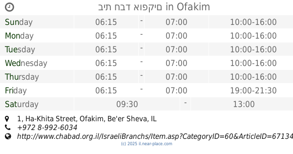
1.553 km
בית חבד אופקים
Ha-Khita Street 1, Ofakim
Synagogue
read more
1.559 km
בית כנסת בית מנחם
אופקים
Synagogue
read more
📑
all categories
Accounting
Administrative area level 1
Administrative area level 2
Airport
Amusement park
Aquarium
Art gallery
Atm
Bakery
Bank
Bar
Beauty salon
Bicycle store
Book store
Bowling alley
Bus station
Cafe
Campground
Car dealer
Car rental
Car repair
Car wash
Casino
Cemetery
Church
City hall
Clothing store
Colloquial area
Convenience store
Country
Courthouse
Dentist
Department store
Doctor
Electrician
Electronics store
Embassy
Establishment
Finance
Fire station
Florist
Food
Funeral home
Furniture store
Gas station
General contractor
Grocery or supermarket
Gym
Hair care
Hardware store
Health
Hindu Temple
Home goods store
Hospital
Insurance agency
Intersection
Jewelry store
Laundry
Lawyer
Library
Light rail station
Liquor store
Local government office
Locality
Locksmith
Lodging
Meal delivery
Meal takeaway
Mosque
Movie rental
Movie theater
Moving company
Museum
Natural feature
Neighborhood
Night club
Painter
Park
Parking
Pet store
Pharmacy
Physiotherapist
Place of worship
Plumber
Point of interest
Police
Political
Post office
Premise
Real estate agency
Restaurant
Roofing contractor
Route
Rv park, camping
School
Shoe store
Shopping mall
Spa
Stadium
Storage
Store
Subpremise
Subway station
Supermarket
Synagogue
Taxi stand
Train station
Transit station
Travel agency
University
Veterinary care
Zoo
administrative area level 3
administrative area level 4
sublocality level 1
↑