Synagogue nearby בית הכנסת הגדול סנהדריה המורחבת
Coronavirus disease (COVID-19) Situation
confirmed cases
4841772
deaths
12707
Israel
Synagogue nearby בית הכנסת הגדול סנהדריה המורחבת
בית הכנסת הגדול סנהדריה המורחבת
14, Ma'agalei ha-Rim Levin Street, Jerusalem, IL Израиль
contacts phone
:
+972
Latitude:
31.8032835
, Longitude:
35.2167737
larger map & directions
read more
nearest Synagogue
45 m
Chabad Lubavitch Synagogue
Ma'agalei ha-Rim Levin Street 14, Jerusalem
Synagogue
read more
149 m
בית הכנסת עזרת תורה
ירושלים
Synagogue
read more
298 m
בית כנסת בק
הרטום 8, ירושלים
Synagogue
read more
549 m
בית כנסת אביר יעקב
Ezrat Tora Street 33, Jerusalem
Synagogue
read more
572 m
בית המדרש אהל משה שע"י המשגיח רבי דן סגל
גבעת משה 8, ירושלים
Synagogue
read more
615 m
בית הכנסת של גאבד ירושלים
גבעת משה 4, ירושלים
Synagogue
read more
710 m
Beit Midrash Shevet ha-Levi
Jerusalem
Synagogue
read more
767 m
בית הכנסת
Jerusalem
Synagogue
read more
769 m
בית כנסת נווה שלום
שאול המלך, ירושלים
Synagogue
read more
769 m
בית כנסת נווה שלום
Sha'ul ha-Melekh Street, Jerusalem
Synagogue
read more
770 m
Chabad of Jerusalem
Uriel Street 5, Jerusalem
Synagogue
read more
770 m
בית חבד
Uriel Street 5, ירושלים
Synagogue
read more
773 m
Ahavat Israel Synagogue
Jerusalem
Synagogue
read more
783 m
The synagogue was Esther
Jerusalem
Synagogue
read more
786 m
בית כנסת בית ישראל
Even ha-Azel Street 21, Jerusalem
Synagogue
read more
796 m
בית הכנסת ובית המדרש תורת חכם עיה''ק ירושלים
אוהלי יוסף 18, ירושלים
Synagogue
read more
841 m
בית מדרש הגדול סלאנים
דורש טוב 4-18, ירושלים
Synagogue
read more
858 m
ביהמ''ד פונביז
אבן האזל 21-11, ירושלים
Synagogue
read more
882 m
אהבת תורה
תורת חסד 1, ירושלים
Synagogue
read more
921 m
בית כנסת זכרון גרשון
אוהלי יוסף 3, ירושלים
Synagogue
read more
928 m
Light of Life Synagogue
Ets Hadar Street 7, Jerusalem
Synagogue
read more
1.004 km
Or Torah
Elkana Street 21, Jerusalem
Synagogue
read more
1.095 km
ביהמד טריסק
מנחם משיב 1, ירושלים
Synagogue
read more
1.099 km
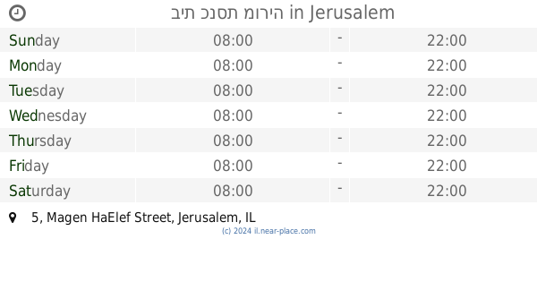
בית כנסת מוריה
Magen HaElef Street 5, Jerusalem
Synagogue
read more
1.099 km
בית כנסת מוריה
מגן האלף 5, ירושלים
Synagogue
read more
📑
all categories
Accounting
Administrative area level 1
Administrative area level 2
Airport
Amusement park
Aquarium
Art gallery
Atm
Bakery
Bank
Bar
Beauty salon
Bicycle store
Book store
Bowling alley
Bus station
Cafe
Campground
Car dealer
Car rental
Car repair
Car wash
Casino
Cemetery
Church
City hall
Clothing store
Colloquial area
Convenience store
Country
Courthouse
Dentist
Department store
Doctor
Electrician
Electronics store
Embassy
Establishment
Finance
Fire station
Florist
Food
Funeral home
Furniture store
Gas station
General contractor
Grocery or supermarket
Gym
Hair care
Hardware store
Health
Hindu Temple
Home goods store
Hospital
Insurance agency
Intersection
Jewelry store
Laundry
Lawyer
Library
Light rail station
Liquor store
Local government office
Locality
Locksmith
Lodging
Meal delivery
Meal takeaway
Mosque
Movie rental
Movie theater
Moving company
Museum
Natural feature
Neighborhood
Night club
Painter
Park
Parking
Pet store
Pharmacy
Physiotherapist
Place of worship
Plumber
Point of interest
Police
Political
Post office
Premise
Real estate agency
Restaurant
Roofing contractor
Route
Rv park, camping
School
Shoe store
Shopping mall
Spa
Stadium
Storage
Store
Subpremise
Subway station
Supermarket
Synagogue
Taxi stand
Train station
Transit station
Travel agency
University
Veterinary care
Zoo
administrative area level 3
administrative area level 4
sublocality level 1
↑