Synagogue nearby בית חבד א.ת אשדוד
Israel
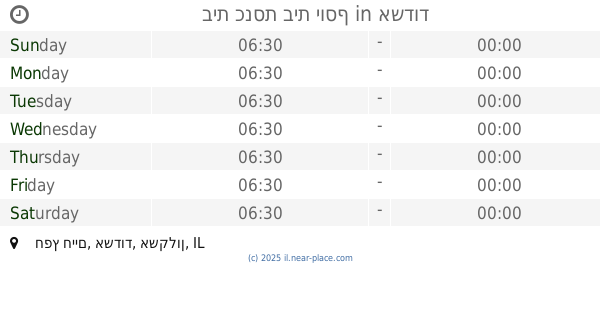
Synagogue nearby בית חבד א.ת אשדוד
בית חבד א.ת אשדוד
7, HaMasger Street, Ashdod, Ashkelon, IL Израиль
contacts phone
:
+972 8-931-6770
website:
chabadashdod.com
Latitude:
31.813923
, Longitude:
34.669021
larger map & directions
read more
nearest Synagogue
בית חבד א.ת אשדוד
המסגר 7, אשדוד
Synagogue
read more
1.229 km
Synagogue Western Lamp
Hativat HaNegev Street 9, Ashdod
Synagogue
read more
1.309 km
Western candle synagogue
Hativat HaNegev Street 9, Ashdod
Synagogue
read more
1.442 km
בי"כ נתיבי החיים
הרב שמואל רוזובסקי 5, אשדוד
Synagogue
read more
1.489 km
בית הכנסת היכל אירית
אשדוד
Synagogue
read more
1.489 km
בית הכנסת היכל אירית
Ashdod
Synagogue
read more
1.55 km
Sing Isaac Synagogue
Ashdod
Synagogue
read more
1.571 km
בית כנסת לעולי הודו קהילת בני ישראל
קרית אברמסקי, מרכז מסחרי,רח' שמואל רוזובסקי, אשדוד
Synagogue
read more
1.634 km
בית כנסת זכרון יוסף
אשדוד
Synagogue
read more
1.78 km
היכל דוד
Ashdod
Synagogue
read more
1.94 km
Seed of Abraham Synagogue
Ashdod
Synagogue
read more
1.954 km
בית הכנסת חבד
רבי עקיבא 4, אשדוד
Synagogue
read more
1.993 km
בית הכנסת לעולי בבל ששון רונין סלומון
אשדוד
Synagogue
read more
2.014 km
בית כנסת בית יוסף
Khafets Khayim Street, Ashdod
Synagogue
read more
2.014 km
בית כנסת בית יוסף
חפץ חיים, אשדוד
Synagogue
read more
2.08 km
בית כנסת אור מכלוף ומרים
Ashdod
Synagogue
read more
2.081 km
בית כנסת אוהל - יעקב
אשדוד
Synagogue
read more
2.094 km
ישיבת פיטסבורג
צדקת יוסף 1, אשדוד
Synagogue
read more
2.129 km
בית כנסת מגן - רפאל
אשדוד
Synagogue
read more
2.152 km
בית כנסת בית ישועה אהל יצחק
Ahi Eilat Street 10, Ashdod
Synagogue
read more
2.187 km
בית כנסת אהל מועד
Ashdod
Synagogue
read more
2.251 km
בית כנסת החידא
22, Yitshak HaNassi Street, Ashdod
Synagogue
read more
2.501 km
בית כנסת קול יעקב
Ashdod
Synagogue
read more
2.536 km
רינת זכריה
אשדוד
Synagogue
read more
2.646 km
בית כנסת בני קדושים
אשדוד
Synagogue
read more
📑
all categories
Accounting
Administrative area level 1
Administrative area level 2
Airport
Amusement park
Aquarium
Art gallery
Atm
Bakery
Bank
Bar
Beauty salon
Bicycle store
Book store
Bowling alley
Bus station
Cafe
Campground
Car dealer
Car rental
Car repair
Car wash
Casino
Cemetery
Church
City hall
Clothing store
Colloquial area
Convenience store
Country
Courthouse
Dentist
Department store
Doctor
Electrician
Electronics store
Embassy
Establishment
Finance
Fire station
Florist
Food
Funeral home
Furniture store
Gas station
General contractor
Grocery or supermarket
Gym
Hair care
Hardware store
Health
Hindu Temple
Home goods store
Hospital
Insurance agency
Intersection
Jewelry store
Laundry
Lawyer
Library
Light rail station
Liquor store
Local government office
Locality
Locksmith
Lodging
Meal delivery
Meal takeaway
Mosque
Movie rental
Movie theater
Moving company
Museum
Natural feature
Neighborhood
Night club
Painter
Park
Parking
Pet store
Pharmacy
Physiotherapist
Place of worship
Plumber
Point of interest
Police
Political
Post office
Premise
Real estate agency
Restaurant
Roofing contractor
Route
Rv park, camping
School
Shoe store
Shopping mall
Spa
Stadium
Storage
Store
Subpremise
Subway station
Supermarket
Synagogue
Taxi stand
Train station
Transit station
Travel agency
University
Veterinary care
Zoo
administrative area level 3
administrative area level 4
sublocality level 1
↑