Store nearby איתי לפיד
Coronavirus disease (COVID-19) Situation
confirmed cases
4841772
deaths
12707
Israel
Store nearby איתי לפיד
איתי לפיד
טשרניחובסקי 11, תל אביב יפו ישראל
contacts phone
:
+972
Latitude:
32.0717467
, Longitude:
34.7710955
read more
nearest Store
81 m
Nippon Premium brands made in Japan
טשרניחובסקי 21, תל אביב יפו
Store
read more
276 m
יפית מפה ומפית
נחלת בנימין 1, תל אביב יפו
Store
read more
376 m
Even Gallery
Rabbi Meir Street 40, Tel Aviv-Yafo
Store
read more
485 m
מסלול עודפים
44, Bograshov Street, Tel Aviv-Yafo
Store
read more
499 m
עולם הדפוס - בית דפוס היעיל בישראל
Ben Tsiyon Boulevard 8, Tel Aviv-Yafo
Store
read more
547 m
דווקא גורמה
הכרמל 34, תל אביב יפו
Store
read more
566 m
אדידס
דיזנגוף 50, תל אביב יפו
Store
read more
584 m
בראנצו׳ס
58, Retsif Herbert Samuel Street, Tel Aviv-Yafo
Store
read more
590 m
קרביץ דיזינגוף
קניון דיזנגוף, דיזנגוף 50, תל אביב יפו
Store
read more
592 m
CONVERSION
Ben Yehuda Street 32, Tel Aviv-Yafo
Store
read more
606 m
נוריאל משה
אלנבי 94, תל אביב יפו
Store
read more
623 m
קפה תמתי caffé Tamati
יחיא קאפח, שוק הכרמל, תל אביב יפו
Store
read more
637 m
אלגנט
Nahalat Binyamin Street 33, Tel Aviv-Yafo
Store
read more
663 m
Avnet Belts
81, Dizengoff Street, Tel Aviv-Yafo
Store
read more
670 m
Body Shop
Allenby Street 98, Tel Aviv-Yafo
Store
read more
695 m
Green Vaper
Bar Giyora Street 26, Tel Aviv-Yafo
Store
read more
750 m
שושו סנטר
הירקון 88, תל אביב יפו
Store
read more
752 m
J Well Tel Aviv - ג ואל תל אביב
Ben Yehuda Street 45, Tel Aviv-Yafo
Store
read more
837 m
איי 2 זי יבנה
ת.ד 421, יבנה
Store
read more
837 m
A2 Z Yavne
ת.ד 421, יבנה
Store
read more
910 m
גל מכשירי שמיעה בע"מ
Zamenhoff Street 32, Tel Aviv-Yafo
Store
read more
1.01 km
Tal Kantero HappyBags טל קנטרו תיקים
דיזנגוף 113, תל אביב יפו
Store
read more
1.061 km
חלום מתוק
שלמה אבן גבירול 33, תל אביב יפו
Store
read more
1.172 km
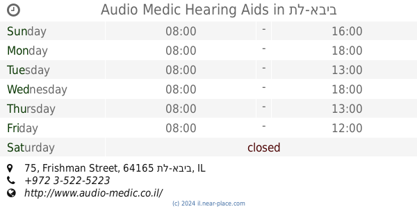
Audio Medic Hearing Aids
Frishman Street 75, תל-אביב
Store
read more
1.235 km
האחים קוואז בעמ
Derech Menachem Begin 27, Tel Aviv-Yafo
Store
read more
📑
all categories
Accounting
Administrative area level 1
Administrative area level 2
Airport
Amusement park
Aquarium
Art gallery
Atm
Bakery
Bank
Bar
Beauty salon
Bicycle store
Book store
Bowling alley
Bus station
Cafe
Campground
Car dealer
Car rental
Car repair
Car wash
Casino
Cemetery
Church
City hall
Clothing store
Colloquial area
Convenience store
Country
Courthouse
Dentist
Department store
Doctor
Electrician
Electronics store
Embassy
Establishment
Finance
Fire station
Florist
Food
Funeral home
Furniture store
Gas station
General contractor
Grocery or supermarket
Gym
Hair care
Hardware store
Health
Hindu Temple
Home goods store
Hospital
Insurance agency
Intersection
Jewelry store
Laundry
Lawyer
Library
Light rail station
Liquor store
Local government office
Locality
Locksmith
Lodging
Meal delivery
Meal takeaway
Mosque
Movie rental
Movie theater
Moving company
Museum
Natural feature
Neighborhood
Night club
Painter
Park
Parking
Pet store
Pharmacy
Physiotherapist
Place of worship
Plumber
Point of interest
Police
Political
Post office
Premise
Real estate agency
Restaurant
Roofing contractor
Route
Rv park, camping
School
Shoe store
Shopping mall
Spa
Stadium
Storage
Store
Subpremise
Subway station
Supermarket
Synagogue
Taxi stand
Train station
Transit station
Travel agency
University
Veterinary care
Zoo
administrative area level 3
administrative area level 4
sublocality level 1
↑