Store nearby תבליני נבון
Israel
Store nearby תבליני נבון
תבליני נבון
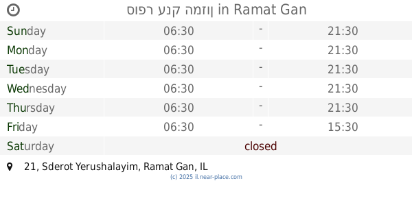
Sderot Yerushalayim 20, Ramat Gan Израиль
contacts phone
:
+972
Latitude:
32.0746035
, Longitude:
34.8207237
read more
nearest Store
72 m
סופר ענק המזון
Sderot Yerushalayim 21, Ramat Gan
Supermarket
Grocery or supermarket
Food
Point of interest
Store
Establishment
read more
221 m
רמי לוי בשכונה
David Ben Gurion Road 182, Giv'atayim
Supermarket
Grocery or supermarket
Food
Point of interest
Store
Establishment
read more
271 m
עלית הממתקים
Sderot Yerushalayim 42, Ramat Gan
Store
read more
301 m
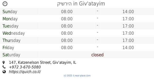
קישריה
Katzenelson Street 147, Giv'atayim
Cafe
Restaurant
Food
Point of interest
Store
Establishment
read more
445 m
מעבדת סלולר
גבעתיים
Store
read more
483 m
שוק החקלאים רג
עוזיאל 92, רמת גן
Store
read more
486 m
דפוס קלאסי פרינט
עוזיאל 92, רמת גן
Store
read more
636 m
כחילה פתרונות הדפסה בעמ
דרך נגבה 20, רמת גן
Store
read more
659 m
Tom's cafe
Sirkin Street 16, Ramat Gan
Cafe
Food
Point of interest
Store
Establishment
read more
672 m
אבי רחמים אטליז
סירקין 15, גבעתיים
Store
read more
682 m
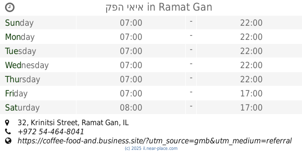
קפה יאיא
Krinitsi Street 32, Ramat Gan
Cafe
Food
Point of interest
Store
Establishment
read more
683 m
קצביית מיכאל
קריניצי 18, רמת גן
Store
read more
709 m
Shilav
Krinitsi Street 7, Ramat Gan
Store
read more
756 m
סקס סיטי
Arlozorov Street 1, Ramat Gan
Store
read more
769 m
Wertheimer Sports
חיים לנדאו 7A, רמת גן
Store
read more
769 m
Wertheimer Sports
Khayim Landau Street 7A, Ramat Gan
Store
read more
780 m
Egozim
חיים לנדאו 7A, רמת גן
Store
read more
786 m
BODY SHOP
חיים לנדאו 7, רמת גן
Store
read more
793 m
Rudi
Khayim Landau Street 7A, Ramat Gan
Store
read more
829 m
ספיישל פרי
בארי 6, בני ברק
Store
read more
840 m
Pets
ביאליק 18, רמת גן
Store
read more
860 m
Sports Line
Bialik Street 15, Ramat Gan
Store
read more
910 m
ארנקי ארפל
ביאליק 21, רמת גן
Store
read more
1.311 km
Pais Lottery
Derech Yitshak Rabin 53, Giv'atayim
Store
read more
1.315 km
Le Roy Rebe
Derech Yitshak Rabin 53, Giv'atayim
Store
read more
📑
all categories
Accounting
Administrative area level 1
Administrative area level 2
Airport
Amusement park
Aquarium
Art gallery
Atm
Bakery
Bank
Bar
Beauty salon
Bicycle store
Book store
Bowling alley
Bus station
Cafe
Campground
Car dealer
Car rental
Car repair
Car wash
Casino
Cemetery
Church
City hall
Clothing store
Colloquial area
Convenience store
Country
Courthouse
Dentist
Department store
Doctor
Electrician
Electronics store
Embassy
Establishment
Finance
Fire station
Florist
Food
Funeral home
Furniture store
Gas station
General contractor
Grocery or supermarket
Gym
Hair care
Hardware store
Health
Hindu Temple
Home goods store
Hospital
Insurance agency
Intersection
Jewelry store
Laundry
Lawyer
Library
Light rail station
Liquor store
Local government office
Locality
Locksmith
Lodging
Meal delivery
Meal takeaway
Mosque
Movie rental
Movie theater
Moving company
Museum
Natural feature
Neighborhood
Night club
Painter
Park
Parking
Pet store
Pharmacy
Physiotherapist
Place of worship
Plumber
Point of interest
Police
Political
Post office
Premise
Real estate agency
Restaurant
Roofing contractor
Route
Rv park, camping
School
Shoe store
Shopping mall
Spa
Stadium
Storage
Store
Subpremise
Subway station
Supermarket
Synagogue
Taxi stand
Train station
Transit station
Travel agency
University
Veterinary care
Zoo
administrative area level 3
administrative area level 4
sublocality level 1
↑