Store nearby Rainbow of flavors
Coronavirus disease (COVID-19) Situation
confirmed cases
4841772
deaths
12707
Israel
Store nearby Rainbow of flavors
Rainbow of flavors
2, HaYahalomim Street, Ashdod, Ashkelon, IL Israel
contacts phone
:
+972 8-956-0199
website:
www.keshet-teamim.co.il
Latitude:
31.8118113
, Longitude:
34.6606814
larger map & directions
read more
nearest Store
179 m
AA Aire Y Respuestos
Ashdod
Store
read more
221 m
MTI
Ba'alei HaMelacha Street 4, Ashdod
Store
read more
325 m
Livnat Albo חתונה לבנה
האורגים 19, אשדוד
Store
read more
376 m
Jungle
מתחם סטאר סנטר, אשדוד
Store
read more
386 m
טויז4פאן - חנות סקס
התקשורת 10, Ashdod
Store
read more
432 m
ארנקי שאולי
אשדוד
Store
read more
457 m
Бэйби Лав
HaOrgim Street 18, Ashdod
Store
read more
465 m
SACARA
ז׳בוטינסקי 45 מתחם סטאר סנטר, אשדוד
Store
read more
507 m
קאובוי מוצרי פרסום בעמ
האורגים 24, אשדוד
Store
read more
509 m
Rejuvi Israel
HaOrgim Street 35, Ashdod
Store
read more
534 m
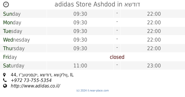
adidas Store Ashdod
Star Centre, ז'בוטינסקי 44, אשדוד
Store
read more
570 m
Luzia Cosmetics
Ha-Avoda Street 69, Ashdod
Store
read more
617 m
Barry signs
Ha-Avoda Street 38, Ashdod
Store
read more
619 m
Laline
ז'בוטינסקי 39, אשדוד
Store
read more
638 m
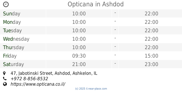
Opticana
Jabotinski Street 47, Ashdod
Store
read more
645 m
מישל שלטים - אזולאי מאיר
Ha-Avoda Street 34, Ashdod
Store
read more
645 m
מישל שלטים - אזולאי מאיר
העבודה 34, אשדוד
Store
read more
692 m
טויס אר אס
מתחם סטאר סנטר, ז'בוטינסקי 43, אשדוד
Store
read more
693 m
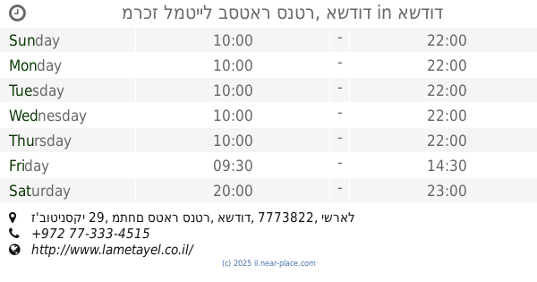
מרכז למטייל בסטאר סנטר, אשדוד
ז'בוטינסקי 29, מתחם סטאר סנטר, אשדוד
Store
read more
755 m
שלטי אשדוד
המסגר 2, אשדוד
Store
read more
967 m
מגה חד פעמי
Kibuts Galuyot Street 1, Ashdod
Store
read more
979 m
פרו וולט
מרכז מסחרי ב- חנות 43, Ashdod
Store
read more
1.001 km
קצביה בשוק
Yoseftal Street 96, Ashdod
Store
read more
1.052 km
קונדיטוריית דני
קיבוץ גלויות 5, אשדוד
Store
read more
1.142 km
ז'קוב דגים
9 Hamelacha St, Ashdod
Store
read more
📑
all categories
Accounting
Administrative area level 1
Administrative area level 2
Airport
Amusement park
Aquarium
Art gallery
Atm
Bakery
Bank
Bar
Beauty salon
Bicycle store
Book store
Bowling alley
Bus station
Cafe
Campground
Car dealer
Car rental
Car repair
Car wash
Casino
Cemetery
Church
City hall
Clothing store
Colloquial area
Convenience store
Country
Courthouse
Dentist
Department store
Doctor
Electrician
Electronics store
Embassy
Establishment
Finance
Fire station
Florist
Food
Funeral home
Furniture store
Gas station
General contractor
Grocery or supermarket
Gym
Hair care
Hardware store
Health
Hindu Temple
Home goods store
Hospital
Insurance agency
Intersection
Jewelry store
Laundry
Lawyer
Library
Light rail station
Liquor store
Local government office
Locality
Locksmith
Lodging
Meal delivery
Meal takeaway
Mosque
Movie rental
Movie theater
Moving company
Museum
Natural feature
Neighborhood
Night club
Painter
Park
Parking
Pet store
Pharmacy
Physiotherapist
Place of worship
Plumber
Point of interest
Police
Political
Post office
Premise
Real estate agency
Restaurant
Roofing contractor
Route
Rv park, camping
School
Shoe store
Shopping mall
Spa
Stadium
Storage
Store
Subpremise
Subway station
Supermarket
Synagogue
Taxi stand
Train station
Transit station
Travel agency
University
Veterinary care
Zoo
administrative area level 3
administrative area level 4
sublocality level 1
↑