Store nearby קופיקט
Israel
Store nearby קופיקט
קופיקט
6, Rashi Street, Ramat Gan, IL Israel
contacts phone
:
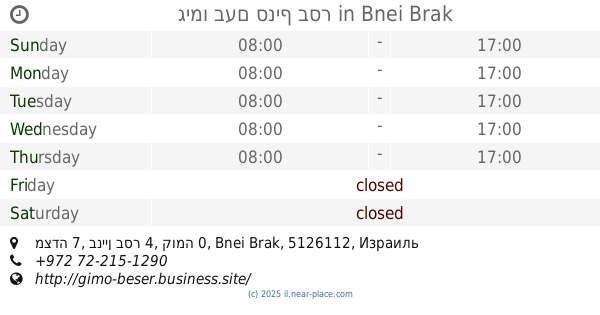
+972 3-751-7562
website:
www.mazonlehayot.co.il
Latitude:
32.0904076
, Longitude:
34.819069
larger map & directions
read more
nearest Store
48 m
Toosh Toosh
133, Ze'ev Jabotinsky Street 129, Ramat Gan
Store
read more
90 m
ספיד קונטרול
Ze'ev Jabotinsky Road 135, Ramat Gan
Store
read more
108 m
Magic Cosmetics
רח' זאב ז'בוטינסקי 116, רמת גן
Store
read more
108 m
Magic Cosmetics
Ze'ev Jabotinsky Street 116, Ramat Gan
Store
read more
351 m
Talia Natural Cosmetics • טליה קוסמטיקה טבעית
Ben Shemen Street 6, Ramat Gan
Store
read more
354 m
Yogolee
Derech Ben Gurion 31, Bnei Brak
Store
read more
363 m
קליית חממה
Rashi Street 40, Ramat Gan
Store
read more
421 m
דפוס שביד בע״מ
יהושע בן נון 4, בני ברק
Store
read more
484 m
Yoram Levy - Ioraoftik Limited clinical optometrist
Ze'ev Jabotinsky Street 93, Ramat Gan
Store
read more
505 m
בשר וקצבים
הרצל 86, רמת גן
Store
read more
608 m
Na'aman
Ze'ev Jabotinsky Road 14, Bnei Brak
Store
read more
664 m
ש.פבוריטה סחר ושווק
ת.ד841, מצדה 8, בני ברק
Store
read more
730 m
דפוס ג'קי
Ze'ev Jabotinsky Street 73, Ramat Gan
Store
read more
733 m
Photo Lottery
Yirmiyahu Street 2, Bnei Brak
Store
read more
734 m
אוטו מודיעין
Ha-Yarkon Street 8, Bnei Brak
Store
read more
744 m
ToMo Candy
Haroe Street 43, Ramat Gan
Store
read more
758 m
גימו בעם סניף בסר
מצדה 7, בניין בסר 4, קומה 0, Bnei Brak
Store
read more
841 m
גלידה אמריקאית אורדע
Ramat Gan
Store
read more
874 m
פרו סנטר
ביאליק 57, רמת גן
Store
read more
905 m
פירות וירקות מובחרים
תלפיות 36, רמת גן
Store
read more
919 m
ארנקי ברגד
רבי עקיבא 56, בני ברק
Store
read more
995 m
Source objects Kods.noifld
Rabi Akiva Street 53, Bnei Brak
Store
read more
1.104 km
יחודי
Ha-Yarkon Street 39, Bnei Brak
Store
read more
1.104 km
פלד סקיוריטי/ peled-security
הירקון 39, בני ברק
Store
read more
1.119 km
ארטיקס
Ha-Yarkon Street 39, Bnei Brak
Store
read more
📑
all categories
Accounting
Administrative area level 1
Administrative area level 2
Airport
Amusement park
Aquarium
Art gallery
Atm
Bakery
Bank
Bar
Beauty salon
Bicycle store
Book store
Bowling alley
Bus station
Cafe
Campground
Car dealer
Car rental
Car repair
Car wash
Casino
Cemetery
Church
City hall
Clothing store
Colloquial area
Convenience store
Country
Courthouse
Dentist
Department store
Doctor
Electrician
Electronics store
Embassy
Establishment
Finance
Fire station
Florist
Food
Funeral home
Furniture store
Gas station
General contractor
Grocery or supermarket
Gym
Hair care
Hardware store
Health
Hindu Temple
Home goods store
Hospital
Insurance agency
Intersection
Jewelry store
Laundry
Lawyer
Library
Light rail station
Liquor store
Local government office
Locality
Locksmith
Lodging
Meal delivery
Meal takeaway
Mosque
Movie rental
Movie theater
Moving company
Museum
Natural feature
Neighborhood
Night club
Painter
Park
Parking
Pet store
Pharmacy
Physiotherapist
Place of worship
Plumber
Point of interest
Police
Political
Post office
Premise
Real estate agency
Restaurant
Roofing contractor
Route
Rv park, camping
School
Shoe store
Shopping mall
Spa
Stadium
Storage
Store
Subpremise
Subway station
Supermarket
Synagogue
Taxi stand
Train station
Transit station
Travel agency
University
Veterinary care
Zoo
administrative area level 3
administrative area level 4
sublocality level 1
↑