Store nearby ח'ואלד מוחמד
Israel
Store nearby ח'ואלד מוחמד
ח'ואלד מוחמד
ישוב, Shaab, Israel
contacts phone
:
+972 4-998-6572
Latitude:
32.88967
, Longitude:
35.238764
larger map & directions
read more
nearest Store
177 m
סופרמרקט אלרנין
3, Shaab
Supermarket
Grocery or supermarket
Store
Food
Point of interest
Establishment
read more
1.257 km
נורית דגן עובדיה ndojewellery
יעד, Ya'ad
Store
read more
1.288 km
דף אור העתקות 2000
ד.נ 20155, יעד
Store
read more
1.304 km
בית קפה לנוער
Ya'ad
Cafe
Food
Store
Point of interest
Establishment
read more
1.832 km
המתוקים שלנו
He-Khatsav Street, Tzurit
Cafe
Food
Store
Point of interest
Establishment
read more
2.074 km
CeramiCake
Ha-Tamar Street, Tzurit
Store
read more
2.074 km
קרמיקייק
Ha-Tamar Street, Tzurit
Store
read more
2.074 km
CeramiCake
התמר, צורית
Store
read more
3.161 km
אורית קמינים
Misgav
Store
read more
3.272 km
חמודי חומרי בנין
Unnamed Road, Majd al-Krum
Store
read more
3.286 km
סאטי מכשירי כתיבה
ישוב, Majd al-Krum
Store
read more
3.583 km
Tali - beauty center
Hativat Etsyoni Street 141, Karmiel
Store
read more
3.621 km
אטליז אבו גואד
מג'ד אל-כרום
Store
read more
3.659 km
Al Salam Pharmacy
כאבול
Store
read more
3.72 km
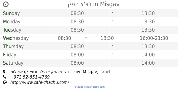
קפה צ'צ'ו
Misgav, מול פארק אוסטרליה ״קפה צ׳צ׳ו״ בוויז
Cafe
Food
Point of interest
Store
Establishment
read more
3.764 km
ואמא מרקט שיווק ציוד רפואי
ת.ד 387, Majd al-Krum
Store
read more
4.13 km
מטיילים
רקפת
Store
read more
4.232 km
Tradition in Israel
HaHagana Street 37, Karmiel
Store
read more
4.322 km
מובייל זון - MobileZone
Ha-Palmakh Street, Karmiel
Store
read more
4.428 km
Ease tricks
Tchelet Street 2, משגב תרדיון
Store
read more
5.103 km
המרכז שלנו
Koranit
Store
read more
5.435 km
מרפדית חטיב
טמרה
Store
read more
5.435 km
מרפדית חטיב
Tamra
Store
read more
5.63 km
קרמיקה אל אמיר בע״מ
אל שאגור, דיר אל-אסד
Store
read more
5.676 km
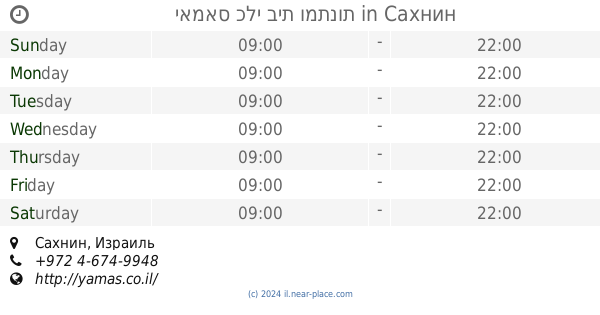
יאמאס כלי בית ומתנות
Sakhnin
Store
read more
📑
all categories
Accounting
Administrative area level 1
Administrative area level 2
Airport
Amusement park
Aquarium
Art gallery
Atm
Bakery
Bank
Bar
Beauty salon
Bicycle store
Book store
Bowling alley
Bus station
Cafe
Campground
Car dealer
Car rental
Car repair
Car wash
Casino
Cemetery
Church
City hall
Clothing store
Colloquial area
Convenience store
Country
Courthouse
Dentist
Department store
Doctor
Electrician
Electronics store
Embassy
Establishment
Finance
Fire station
Florist
Food
Funeral home
Furniture store
Gas station
General contractor
Grocery or supermarket
Gym
Hair care
Hardware store
Health
Hindu Temple
Home goods store
Hospital
Insurance agency
Intersection
Jewelry store
Laundry
Lawyer
Library
Light rail station
Liquor store
Local government office
Locality
Locksmith
Lodging
Meal delivery
Meal takeaway
Mosque
Movie rental
Movie theater
Moving company
Museum
Natural feature
Neighborhood
Night club
Painter
Park
Parking
Pet store
Pharmacy
Physiotherapist
Place of worship
Plumber
Point of interest
Police
Political
Post office
Premise
Real estate agency
Restaurant
Roofing contractor
Route
Rv park, camping
School
Shoe store
Shopping mall
Spa
Stadium
Storage
Store
Subpremise
Subway station
Supermarket
Synagogue
Taxi stand
Train station
Transit station
Travel agency
University
Veterinary care
Zoo
administrative area level 3
administrative area level 4
sublocality level 1
↑