Store nearby הקייטרינג של משה
Israel
Store nearby הקייטרינג של משה
הקייטרינג של משה
VFPF+6X, Kadarim, Israel
contacts phone
:
+972
Latitude:
32.8855491
, Longitude:
35.4749396
larger map & directions
read more
nearest Store
1.516 km
מסיק זיתים עין כמונים
Kadarim
Store
read more
2.031 km
Badimyon Bags
Industrial Park, Hukok
Store
read more
2.031 km
Badimyon Bags
Industrial Park, חוקוק
Store
read more
4.298 km
Baby World
מע'אר
Store
read more
4.332 km
משתלת עץ הזית
ראס עלי
Store
read more
4.369 km
משתלת הפרח הירוק מגאר
807, מע'אר
Store
read more
6.134 km
Jet Lag
8 Street, Qatsrin
Store
read more
6.134 km
Jet Lag
8, קצרין
Store
read more
6.56 km
פרמייר ים המלח Premier Dead Sea
גינוסר בית יגאל אלון, גינוסר
Store
read more
6.602 km
קמפינג שופ
ערז 157, מסד
Store
read more
6.818 km
Butcher Abu Alnaim
Maghar
Store
read more
9.215 km
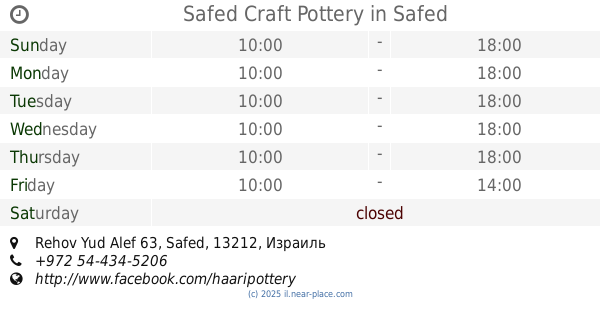
Safed Craft Pottery
Rehov Yud Alef 63, Safed
Store
read more
9.333 km
Trebelki's Stationery Store
Jerusalem Street, Safed
Store
read more
11.35 km
טרקלין חשמל
מתחם ביג, המברג 1, טבריה
Store
read more
11.387 km
Pais Lottery
Ha-Mavreg Street 1, Tiberias
Store
read more
11.474 km
ישמ
מעלה קק"ל 1, טבריה
Store
read more
11.474 km
ישמ
Ma'ale Kakal Street 1, Tiberias
Store
read more
12.085 km
טרקלין חשמל - סניף טבריה
Yehuda Halevi Street, Tiberias
Store
read more
12.327 km
אודיו-מדיק טבריה
כיכר רבין, בית הרופאים ת.ד. 1518, Tiberias
Store
read more
12.478 km
אקספרס טבריה
Ha-Banim Street 6, Tiberias
Supermarket
Grocery or supermarket
Store
Food
Point of interest
Establishment
read more
12.639 km
תבליני כהן
הפרחים, טבריה
Store
read more
14.636 km
FreshPoint
Khutsot Karmi'el Street, Karmiel
Store
read more
14.643 km
Gama Deal
Ma'ale Kamon Street 9, Karmiel
Store
read more
14.904 km
מיכל נגרין - ביג כרמיאל
Big Fashion Center, מעלה כמון 2, כרמיאל
Store
read more
15.392 km
פיקנבס
Matehet Street 32, Karmiel
Store
read more
📑
all categories
Accounting
Administrative area level 1
Administrative area level 2
Airport
Amusement park
Aquarium
Art gallery
Atm
Bakery
Bank
Bar
Beauty salon
Bicycle store
Book store
Bowling alley
Bus station
Cafe
Campground
Car dealer
Car rental
Car repair
Car wash
Casino
Cemetery
Church
City hall
Clothing store
Colloquial area
Convenience store
Country
Courthouse
Dentist
Department store
Doctor
Electrician
Electronics store
Embassy
Establishment
Finance
Fire station
Florist
Food
Funeral home
Furniture store
Gas station
General contractor
Grocery or supermarket
Gym
Hair care
Hardware store
Health
Hindu Temple
Home goods store
Hospital
Insurance agency
Intersection
Jewelry store
Laundry
Lawyer
Library
Light rail station
Liquor store
Local government office
Locality
Locksmith
Lodging
Meal delivery
Meal takeaway
Mosque
Movie rental
Movie theater
Moving company
Museum
Natural feature
Neighborhood
Night club
Painter
Park
Parking
Pet store
Pharmacy
Physiotherapist
Place of worship
Plumber
Point of interest
Police
Political
Post office
Premise
Real estate agency
Restaurant
Roofing contractor
Route
Rv park, camping
School
Shoe store
Shopping mall
Spa
Stadium
Storage
Store
Subpremise
Subway station
Supermarket
Synagogue
Taxi stand
Train station
Transit station
Travel agency
University
Veterinary care
Zoo
administrative area level 3
administrative area level 4
sublocality level 1
↑