Store nearby הגרעין
Israel
Store nearby הגרעין
הגרעין
31, שירתי, גבעת חן, פתח תקווה, IL ישראל
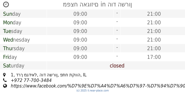
contacts phone
:
+972 9-740-2773
website:
www.hagarin.co.il
Latitude:
32.1678513
, Longitude:
34.8759538
larger map & directions
read more
nearest Store
66 m
דג על הגל
שירתי 33, גבעת חן
Store
read more
204 m
بقالة صغيرة
Givat Hen
Supermarket
Grocery or supermarket
Food
Point of interest
Store
Establishment
read more
589 m
הכפריה
בכניסה למושב, Givat Hen
Store
read more
589 m
הכפריה
בכניסה למושב, גבעת חן
Store
read more
714 m
טווילינגן
הפקאן 11, רמות השבים
Store
read more
714 m
Tweelingen Design
HaPekan Street 11, Ramot HaShavim
Store
read more
803 m
השכרת נגררים
פרדס משותף 31, רעננה
Store
read more
803 m
השכרת נגררים
Pardes Meshutaf Street 31, Ra'anana
Store
read more
1.023 km
משתלת אוהד
משה שרת 59, הוד השרון
Store
read more
1.023 km
משתלת אוהד
Moshe Sharet Street 59, Hod Hasharon
Store
read more
1.299 km
Uri Cohen Stone Art - אורי כהן אמנות באבנים טהורות
Bialik Street 8, Ra'anana
Store
read more
1.326 km
סופר טויס
אחוזה 99, רעננה
Store
read more
1.348 km
Sweet Moments
Jabotinski Street 3, Ra'anana
Store
read more
1.389 km
bella donna
אחוזה 102, רעננה
Store
read more
1.447 km
coffee planet
אחוזה 124, רעננה
Store
read more
1.653 km
Keshet Teamim
Netiv HaAvot 14, Kfar Saba
Supermarket
Grocery or supermarket
Food
Point of interest
Store
Establishment
read more
1.671 km
פסטה דלה קזה - כפר מלל
עין חי 43, כפר מל"ל
Store
read more
1.717 km
היער הקסום
Schwarz Street 22, Ra'anana
Store
read more
1.816 km
נאוה כץ
Har Sinai Street 10, Ra'anana
Store
read more
1.869 km
Vaniglia Hod Hasharon
18, Ramatayim Road, Hod Hasharon
Store
read more
1.951 km
שפע שוק
חפץ חיים 22, רעננה
Store
read more
1.965 km
נעלי ניוז
HaBanim Street 14, Hod Hasharon
Store
read more
2.151 km
היפר זול
דרך רמתיים 78, הוד השרון
Store
read more
2.202 km
מפצח האגוזים
דרך מגדיאל 1, הוד השרון
Store
read more
2.249 km
קוי טאטו | Koi-Tattoo
דרך מגדיאל 8, הוד השרון, ישראל, Hod Hasharon
Store
read more
📑
all categories
Accounting
Administrative area level 1
Administrative area level 2
Airport
Amusement park
Aquarium
Art gallery
Atm
Bakery
Bank
Bar
Beauty salon
Bicycle store
Book store
Bowling alley
Bus station
Cafe
Campground
Car dealer
Car rental
Car repair
Car wash
Casino
Cemetery
Church
City hall
Clothing store
Colloquial area
Convenience store
Country
Courthouse
Dentist
Department store
Doctor
Electrician
Electronics store
Embassy
Establishment
Finance
Fire station
Florist
Food
Funeral home
Furniture store
Gas station
General contractor
Grocery or supermarket
Gym
Hair care
Hardware store
Health
Hindu Temple
Home goods store
Hospital
Insurance agency
Intersection
Jewelry store
Laundry
Lawyer
Library
Light rail station
Liquor store
Local government office
Locality
Locksmith
Lodging
Meal delivery
Meal takeaway
Mosque
Movie rental
Movie theater
Moving company
Museum
Natural feature
Neighborhood
Night club
Painter
Park
Parking
Pet store
Pharmacy
Physiotherapist
Place of worship
Plumber
Point of interest
Police
Political
Post office
Premise
Real estate agency
Restaurant
Roofing contractor
Route
Rv park, camping
School
Shoe store
Shopping mall
Spa
Stadium
Storage
Store
Subpremise
Subway station
Supermarket
Synagogue
Taxi stand
Train station
Transit station
Travel agency
University
Veterinary care
Zoo
administrative area level 3
administrative area level 4
sublocality level 1
↑