Store nearby דיוורית - דפוס
Israel
Store nearby דיוורית - דפוס
דיוורית - דפוס
57, Rothschild Street, 4420123, Kefar Sava, Petach Tikva, IL Israel
contacts phone
:
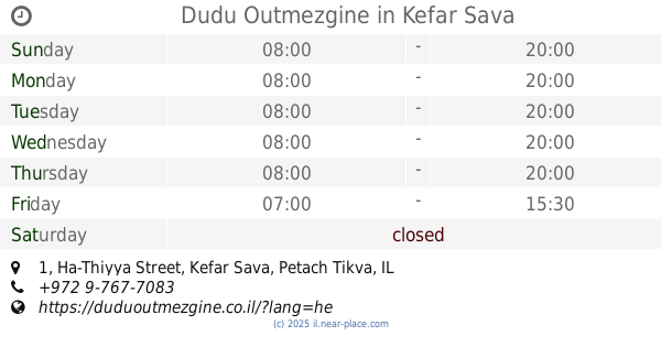
+972 9-765-5588
website:
divorit.co.il
Latitude:
32.1759597
, Longitude:
34.9083253
larger map & directions
read more
nearest Store
116 m
SACARA
ויצמן 95, כפר סבא
Store
read more
126 m
אילנית צבי קוסנטיקאית ומאפרת
Rothschild Street 47, Kefar Sava
Store
read more
150 m
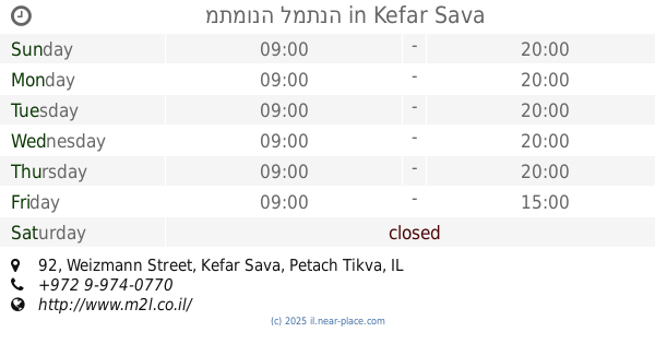
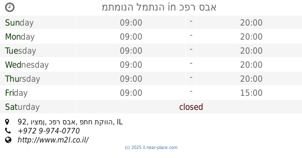
מתמונה למתנה
Weizmann Street 92, Kefar Sava
Store
read more
150 m
מתמונה למתנה
ויצמן 92, כפר סבא
Store
read more
161 m
אלדין ספרי לימוד וציוד משרדי
ויצמן 89, כפר סבא
Store
read more
212 m
גלידה גולדה
ויצמן, כפר סבא
Store
read more
238 m
102 Balloons
Jerusalem Street 30, Kefar Sava
Store
read more
240 m
ברכת יצחק
ירושלים 30, כפר סבא
Store
read more
270 m
יפת חמדת אבות
ויצמן 132, כפר סבא
Store
read more
276 m
הובי
נחשון פינת ירושלים 10, Kefar Sava
Store
read more
297 m
הפולניה
המייסדים 14, כפר סבא
Store
read more
310 m
וי אי פטס
Hertsel Street 55, Kefar Sava
Store
read more
310 m
וי אי פטס
הרצל 55, כפר סבא
Store
read more
356 m
Dudu Outmezgine
Ha-Thiyya Street 1, Kefar Sava
Bakery
Cafe
Food
Point of interest
Store
Establishment
read more
368 m
Home'is הומיז
David Elazar Street 8, Kefar Sava
Cafe
Restaurant
Food
Point of interest
Store
Establishment
read more
465 m
Golf Kids
רח כצנלסון, קניון ערים, Kefar Sava
Store
read more
491 m
ללין
ברל כצנלסון 14, כפר סבא
Store
read more
494 m
רד ספורט
ברל כצנלסון 14, כפר סבא
Store
read more
567 m
אינג'וייסטיק
Tel-Hay Street 31, Kefar Sava
Store
read more
712 m
אופטיקה אוריאנטה (Optica Oriente)
העמק 17, כפר סבא
Store
read more
820 m
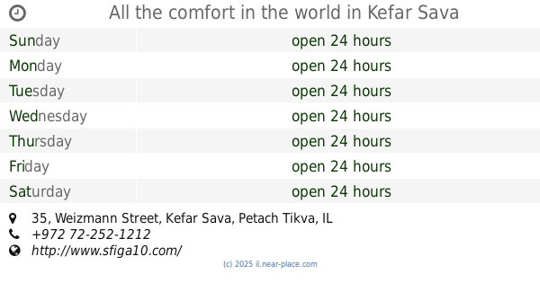
All the comfort in the world
Weizmann Street 35, Kefar Sava
Store
read more
883 m
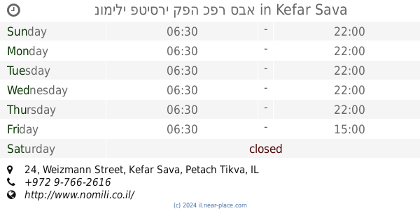
נומילי פטיסרי קפה כפר סבא
Weizmann Street 24, Kefar Sava
Bakery
Cafe
Food
Point of interest
Store
Establishment
read more
915 m
נרגילה בוטיק
Weizmann Street 163, Kefar Sava
Store
read more
921 m
פירות וירקות שלומי
גורדון 18, כפר סבא
Store
read more
1.041 km
G-Shirt World
Hativat Golani Street 11, Kefar Sava
Store
read more
📑
all categories
Accounting
Administrative area level 1
Administrative area level 2
Airport
Amusement park
Aquarium
Art gallery
Atm
Bakery
Bank
Bar
Beauty salon
Bicycle store
Book store
Bowling alley
Bus station
Cafe
Campground
Car dealer
Car rental
Car repair
Car wash
Casino
Cemetery
Church
City hall
Clothing store
Colloquial area
Convenience store
Country
Courthouse
Dentist
Department store
Doctor
Electrician
Electronics store
Embassy
Establishment
Finance
Fire station
Florist
Food
Funeral home
Furniture store
Gas station
General contractor
Grocery or supermarket
Gym
Hair care
Hardware store
Health
Hindu Temple
Home goods store
Hospital
Insurance agency
Intersection
Jewelry store
Laundry
Lawyer
Library
Light rail station
Liquor store
Local government office
Locality
Locksmith
Lodging
Meal delivery
Meal takeaway
Mosque
Movie rental
Movie theater
Moving company
Museum
Natural feature
Neighborhood
Night club
Painter
Park
Parking
Pet store
Pharmacy
Physiotherapist
Place of worship
Plumber
Point of interest
Police
Political
Post office
Premise
Real estate agency
Restaurant
Roofing contractor
Route
Rv park, camping
School
Shoe store
Shopping mall
Spa
Stadium
Storage
Store
Subpremise
Subway station
Supermarket
Synagogue
Taxi stand
Train station
Transit station
Travel agency
University
Veterinary care
Zoo
administrative area level 3
administrative area level 4
sublocality level 1
↑