Store nearby Clalit Health Center Misgav
Israel
Store nearby Clalit Health Center Misgav
Clalit Health Center Misgav
Misgav, Israel
contacts phone
:
+972 4-902-7300
website:
www.clalit.co.il
Latitude:
32.8585425
, Longitude:
35.2607517
larger map & directions
read more
nearest Store
188 m
מטיילים
רקפת
Store
read more
214 m
Zepo
Tut Street 2, Rakefet
Store
read more
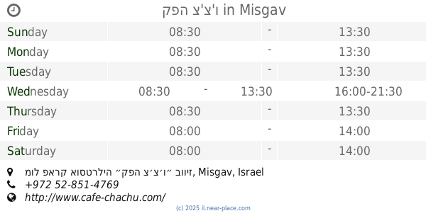
309 m
קפה צ'צ'ו
Misgav, מול פארק אוסטרליה ״קפה צ׳צ׳ו״ בוויז
Cafe
Food
Point of interest
Store
Establishment
read more
708 m
משתלת גליל צמחים
אורן, רקפת
Store
read more
708 m
משתלת גליל צמחים
Oren Street, Rakefet
Store
read more
1.536 km
Accurate Sensors Technology
כחול 2 כחול 2
Store
read more
1.628 km
א.ש.ד תרדיון
כחול 1 כחול 1
Store
read more
1.628 km
ESHED Teradyon
כחול 1 כחול 1
Store
read more
1.73 km
יערית האמנות שבטעם
ירוק פארק תעשיה תרדיון
Cafe
Bakery
Store
Food
Point of interest
Establishment
read more
1.747 km
מעגלי מים
Shekhanya
Store
read more
1.774 km
אור משגב מכון העתקות
Katom Street 4, 6
Store
read more
1.774 km
אור משגב מכון העתקות
כתום 4, 6
Store
read more
1.787 km
תדביק גליל
כתום 2
Store
read more
1.796 km
תדביק
פארק תעשיות משגב, כתום, משגב
Store
read more
1.81 km
המרכז שלנו
Koranit
Store
read more
1.828 km
Ease tricks
Tchelet Street 2, משגב תרדיון
Store
read more
1.828 km
קלות להטוטים
תכלת 2, משגב תרדיון
Store
read more
1.986 km
אומגה 3 גליל בעמ
Shekhanya
Store
read more
2.487 km
טוסטי
Yodfat
Cafe
Point of interest
Store
Food
Establishment
read more
2.625 km
הולך בתל
יודפת
Store
read more
2.638 km
המלבושיה, מתחם בואכה יודפת, יודפת
מתחם בואכה יודפת, יודפת
Store
read more
2.646 km
Tootsie Cuisine Deli
בואכה יודפת, Yodfat
Store
read more
2.705 km
Faddy Market
צומת, Kawkab 'Abu a-lHija
Supermarket
Grocery or supermarket
Food
Point of interest
Store
Establishment
read more
2.712 km
בוסתן יודפת
805, Yodfat
Store
read more
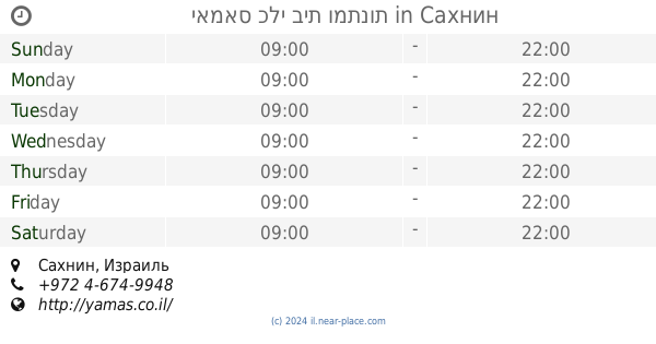
2.86 km
יאמאס כלי בית ומתנות
Sakhnin
Store
read more
📑
all categories
Accounting
Administrative area level 1
Administrative area level 2
Airport
Amusement park
Aquarium
Art gallery
Atm
Bakery
Bank
Bar
Beauty salon
Bicycle store
Book store
Bowling alley
Bus station
Cafe
Campground
Car dealer
Car rental
Car repair
Car wash
Casino
Cemetery
Church
City hall
Clothing store
Colloquial area
Convenience store
Country
Courthouse
Dentist
Department store
Doctor
Electrician
Electronics store
Embassy
Establishment
Finance
Fire station
Florist
Food
Funeral home
Furniture store
Gas station
General contractor
Grocery or supermarket
Gym
Hair care
Hardware store
Health
Hindu Temple
Home goods store
Hospital
Insurance agency
Intersection
Jewelry store
Laundry
Lawyer
Library
Light rail station
Liquor store
Local government office
Locality
Locksmith
Lodging
Meal delivery
Meal takeaway
Mosque
Movie rental
Movie theater
Moving company
Museum
Natural feature
Neighborhood
Night club
Painter
Park
Parking
Pet store
Pharmacy
Physiotherapist
Place of worship
Plumber
Point of interest
Police
Political
Post office
Premise
Real estate agency
Restaurant
Roofing contractor
Route
Rv park, camping
School
Shoe store
Shopping mall
Spa
Stadium
Storage
Store
Subpremise
Subway station
Supermarket
Synagogue
Taxi stand
Train station
Transit station
Travel agency
University
Veterinary care
Zoo
administrative area level 3
administrative area level 4
sublocality level 1
↑