Store nearby BAMOSS אשדוד
Israel
Store nearby BAMOSS אשדוד
BAMOSS אשדוד
Ашдод, Израиль
contacts phone
:
+972 8-933-3795
Latitude:
31.7836925
, Longitude:
34.6531856
larger map & directions
read more
nearest Store
52 m
Yakirsbike
Yakinton Street 1, Ashdod
Store
read more
65 m
יקיר אקסטרים Yakir extreme
77641, Menachem Begin Boulevard אשדוד, Ashdod
Store
read more
70 m
גרעיני עפולה - מרכז הפיצוחים והממתקים הגדול באזור
מרכז כלניות, Menachem Begin Blvd 135, Ashdod
Store
read more
95 m
לנדאו דגים
מרכז כלניות אשדוד
Store
read more
279 m
WeLoveCoffee ווי לוב קופי
Abba Eban Boulevard 18, Herzliya
Store
read more
279 m
WeLoveCoffee ווי לוב קופי
שדרות אבא אבן 18, הרצליה
Store
read more
460 m
דיגיטל - הדפסה על חולצות
הנביאים 1, אשדוד
Store
read more
684 m
קינג סלמון אשדוד
Gei Oni Street, Ashdod
Store
read more
806 m
קופידאטה
תש"ח 9, אשדוד
Store
read more
886 m
Yogic - Yogurt Bar
Ashdod
Store
read more
892 m
שואו אופטיק
רבי מאיר בעל הנס 24, אשדוד
Store
read more
942 m
House of Fish 2000
Dov Gur Street 31, Ashdod
Store
read more
964 m
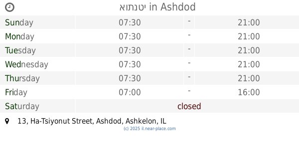
אותנטי
Ha-Tsiyonut Street 13, Ashdod
Supermarket
Grocery or supermarket
Food
Point of interest
Store
Establishment
read more
984 m
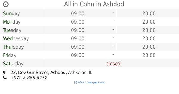
All in Cohn
Dov Gur Street 23, Ashdod
Store
read more
984 m
כל בו כהן
דב גור 23, אשדוד
Store
read more
1.002 km
ismoke+
Shlomo Ben Yosef Street 18-20, Ashdod
Store
read more
1.003 km
אייסמוק פלוס
Shlomo Ben Yosef Street, Ashdod
Store
read more
1.065 km
שפע טרי וקפוא אדלר בעמ
רשב"י 17, אשדוד
Store
read more
1.074 km
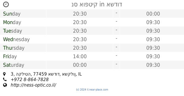
נס אופטיק
HaKlita Street 3, Ashdod
Store
read more
1.074 km
נס אופטיק
הקליטה 3, אשדוד
Store
read more
1.156 km
צ'ארניס
Sderot HaRav Levin 23, Ashdod
Store
read more
1.26 km
סוכות לויתן
Rabbi Yohanan ben Zakai Street 188, Ashdod
Store
read more
1.26 km
סוכות לויתן
רבי יוחנן בן זכאי 188, אשדוד
Store
read more
1.277 km
Erroca
Ashdod
Store
read more
1.34 km
רוקסטאר טאטו
העצמאות 2, אשדוד
Store
read more
📑
all categories
Accounting
Administrative area level 1
Administrative area level 2
Airport
Amusement park
Aquarium
Art gallery
Atm
Bakery
Bank
Bar
Beauty salon
Bicycle store
Book store
Bowling alley
Bus station
Cafe
Campground
Car dealer
Car rental
Car repair
Car wash
Casino
Cemetery
Church
City hall
Clothing store
Colloquial area
Convenience store
Country
Courthouse
Dentist
Department store
Doctor
Electrician
Electronics store
Embassy
Establishment
Finance
Fire station
Florist
Food
Funeral home
Furniture store
Gas station
General contractor
Grocery or supermarket
Gym
Hair care
Hardware store
Health
Hindu Temple
Home goods store
Hospital
Insurance agency
Intersection
Jewelry store
Laundry
Lawyer
Library
Light rail station
Liquor store
Local government office
Locality
Locksmith
Lodging
Meal delivery
Meal takeaway
Mosque
Movie rental
Movie theater
Moving company
Museum
Natural feature
Neighborhood
Night club
Painter
Park
Parking
Pet store
Pharmacy
Physiotherapist
Place of worship
Plumber
Point of interest
Police
Political
Post office
Premise
Real estate agency
Restaurant
Roofing contractor
Route
Rv park, camping
School
Shoe store
Shopping mall
Spa
Stadium
Storage
Store
Subpremise
Subway station
Supermarket
Synagogue
Taxi stand
Train station
Transit station
Travel agency
University
Veterinary care
Zoo
administrative area level 3
administrative area level 4
sublocality level 1
↑