Store nearby Aya Market
Coronavirus disease (COVID-19) Situation
confirmed cases
4841772
deaths
12707
Israel
Store nearby Aya Market
Aya Market
كفر قاسم, Kfar Qasem, Israel
contacts phone
:
+972 3-907-1560
Latitude:
32.11312
, Longitude:
34.957139
larger map & directions
read more
nearest Store
80 m
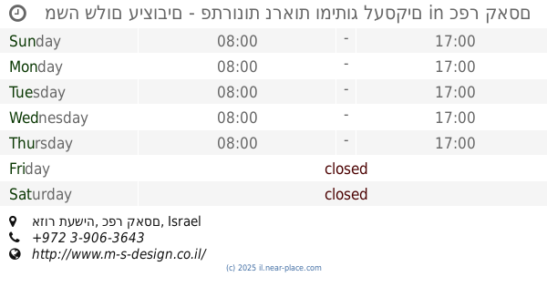
מימדים חומרי שילוט
חמזה, כפר קאסם
Store
read more
80 m
מימדים חומרי שילוט
Hamza Street, Kafr Qasim
Store
read more
160 m
קלאסיקה אשר יבוא והפצה בעמ
Kafr Qasim
Store
read more
170 m
Wood Center
Hamza Street, Kafr Qasim
Store
read more
174 m
קלאסיקה אשר יבוא והפצה בע"מ
א.ת קאסם, Kafr Qasim
Store
read more
174 m
קלאסיקה אשר יבוא והפצה בע"מ
א.ת קאסם, כפר קאסם
Store
read more
233 m
בית האינסטלציה בעמ
חמזה, כפר קאסם
Store
read more
439 m
משרדית נחלים
Kafr Qasim
Store
read more
455 m
קרנושה - אומנות עיטוף הרכב
ליד שוק הציפורים, כפר קאסם
Store
read more
533 m
משה שלום עיצובים - פתרונות נראות ומיתוג לעסקים
אזור תעשיה, כפר קאסם
Store
read more
578 m
גרעיני עפולה
כפר קאסם
Store
read more
652 m
טולה קבוצת זבדה
אזור תעשיה לב הארץ,, ראש העין
Store
read more
703 m
Super Stock
Rosh Haayin
Store
read more
832 m
Kfar Kasm Butcher
Kafr Qasim
Store
read more
838 m
שטניינר סניף פארק אפק
בניין ONE, עמל 1, ראש העין
Store
read more
924 m
משתלת אבני קסם
Kafr Qasim
Store
read more
930 m
3d Printing Center Israel
פ"ת, HaZait Street 2, Kafr Qasim
Store
read more
930 m
3d Printing Center Israel
דרך הית 2, ראש העין
Store
read more
961 m
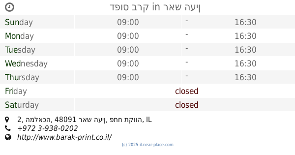
דפוס ברק
המלאכה 2, ראש העין
Store
read more
961 m
דפוס ברק
HaMelacha Street 2, Rosh Haayin
Store
read more
980 m
סטודיו 2 ארט
כפר קאסם
Store
read more
1.001 km
פרטנר
Amal Street 8, Rosh Haayin
Store
read more
1.024 km
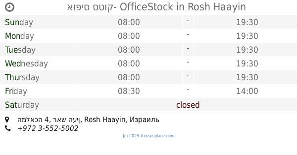
אופיס סטוק- OfficeStock
המלאכה 4, ראש העין, Rosh Haayin
Store
read more
1.048 km
דפוס כפר קאסם
עבד אל כרים קאסם, כפר קאסם
Store
read more
1.063 km
רבגד אריזות
Unnamed Road, Kafr Qasim
Store
read more
📑
all categories
Accounting
Administrative area level 1
Administrative area level 2
Airport
Amusement park
Aquarium
Art gallery
Atm
Bakery
Bank
Bar
Beauty salon
Bicycle store
Book store
Bowling alley
Bus station
Cafe
Campground
Car dealer
Car rental
Car repair
Car wash
Casino
Cemetery
Church
City hall
Clothing store
Colloquial area
Convenience store
Country
Courthouse
Dentist
Department store
Doctor
Electrician
Electronics store
Embassy
Establishment
Finance
Fire station
Florist
Food
Funeral home
Furniture store
Gas station
General contractor
Grocery or supermarket
Gym
Hair care
Hardware store
Health
Hindu Temple
Home goods store
Hospital
Insurance agency
Intersection
Jewelry store
Laundry
Lawyer
Library
Light rail station
Liquor store
Local government office
Locality
Locksmith
Lodging
Meal delivery
Meal takeaway
Mosque
Movie rental
Movie theater
Moving company
Museum
Natural feature
Neighborhood
Night club
Painter
Park
Parking
Pet store
Pharmacy
Physiotherapist
Place of worship
Plumber
Point of interest
Police
Political
Post office
Premise
Real estate agency
Restaurant
Roofing contractor
Route
Rv park, camping
School
Shoe store
Shopping mall
Spa
Stadium
Storage
Store
Subpremise
Subway station
Supermarket
Synagogue
Taxi stand
Train station
Transit station
Travel agency
University
Veterinary care
Zoo
administrative area level 3
administrative area level 4
sublocality level 1
↑