Stadium nearby ملعب الهلال
Coronavirus disease (COVID-19) Situation
confirmed cases
4841772
deaths
12707
Israel
Stadium nearby ملعب الهلال
ملعب الهلال
31°21'09.9"N 34°17'48.7"E ישראל
contacts phone
:
+972
Latitude:
31.352749
, Longitude:
34.29685
read more
nearest Stadium
11.674 km
ملعب الزوايده
شارع الزوايده، الزوايده، الوسطى
Stadium
read more
15.013 km
Municipal Stadium
31°27'20.9"N 34°23'56.7"E
Stadium
read more
23.851 km
Alermouk Stadium
Stadium
read more
28.582 km
Soccer Stadium
נתיבות
Stadium
read more
32.001 km
The Municipal Stadium
Офаким
Stadium
read more
34.425 km
אצטדיון ניר משה
68, ניר משה
Stadium
read more
34.425 km
אצטדיון ניר משה
68, Nir Moshe
Stadium
read more
34.75 km
איצטדיון כדורגל בבנייה
שדרות
Stadium
read more
34.75 km
Stadium (under construction)
Сдерот
Stadium
read more
37.495 km
שום דה סטאדיום
Dorot
Stadium
read more
45.128 km
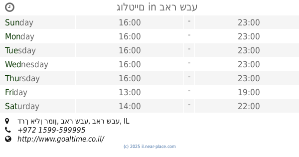
גולטיים
Derech Ilan Ramon, Be'er Sheva
Stadium
read more
45.128 km
גולטיים
דרך אילן רמון, באר שבע
Stadium
read more
45.128 km
גולטיים
1, Derech Ilan Ramon, Be'er Sheva
Stadium
read more
46.69 km
Turner-Stadion
רח' האצ"ל 2, באר שבע
Stadium
read more
46.69 km
Toto Turner Stadium
רח' האצ"ל 2, באר שבע
Stadium
read more
46.69 km
אצטדיון טוטו טרנר
רח' האצ"ל 2, באר שבע
Stadium
read more
46.69 km
Тото Тернер Стадиум
רח' האצ"ל 2, באר שבע
Stadium
read more
46.753 km
איצטדיון
Israel
Stadium
read more
46.753 km
Stadium
Israel
Stadium
read more
50.294 km
איצטדיון טאובל
באר שבע
Stadium
read more
50.294 km
איצטדיון טאובל
Be'er Sheva
Stadium
read more
59.568 km
Kiryat Mal'akhi Municipal Stadium
Kirjat Mal'achi
Stadium
read more
59.568 km
Kiryat Mal'akhi Municipal Stadium
Kiryat Mal'aji
Stadium
read more
59.568 km
Kiryat Mal'akhi Municipal Stadium
Кирьят-Малахи
Stadium
read more
59.568 km
איצטדיון עירוני קרית מלאכי
קרית מלאכי
Stadium
read more
📑
all categories
Accounting
Administrative area level 1
Administrative area level 2
Airport
Amusement park
Aquarium
Art gallery
Atm
Bakery
Bank
Bar
Beauty salon
Bicycle store
Book store
Bowling alley
Bus station
Cafe
Campground
Car dealer
Car rental
Car repair
Car wash
Casino
Cemetery
Church
City hall
Clothing store
Colloquial area
Convenience store
Country
Courthouse
Dentist
Department store
Doctor
Electrician
Electronics store
Embassy
Establishment
Finance
Fire station
Florist
Food
Funeral home
Furniture store
Gas station
General contractor
Grocery or supermarket
Gym
Hair care
Hardware store
Health
Hindu Temple
Home goods store
Hospital
Insurance agency
Intersection
Jewelry store
Laundry
Lawyer
Library
Light rail station
Liquor store
Local government office
Locality
Locksmith
Lodging
Meal delivery
Meal takeaway
Mosque
Movie rental
Movie theater
Moving company
Museum
Natural feature
Neighborhood
Night club
Painter
Park
Parking
Pet store
Pharmacy
Physiotherapist
Place of worship
Plumber
Point of interest
Police
Political
Post office
Premise
Real estate agency
Restaurant
Roofing contractor
Route
Rv park, camping
School
Shoe store
Shopping mall
Spa
Stadium
Storage
Store
Subpremise
Subway station
Supermarket
Synagogue
Taxi stand
Train station
Transit station
Travel agency
University
Veterinary care
Zoo
administrative area level 3
administrative area level 4
sublocality level 1
↑