Shopping mall nearby מרכז פרל סאדאב
Israel
Shopping mall nearby מרכז פרל סאדאב
מרכז פרל סאדאב
אזור, ישראל
contacts phone
:
+972 72-330-4901
website:
www.natamnihul.co.il
Latitude:
32.0247076
, Longitude:
34.8028868
larger map & directions
read more
nearest Shopping mall
ТЦ Садаб
Azor
Shopping mall
read more
357 m
מתחם פאור סנטר חולון
Felix Zandman Street 10, Holon
Shopping mall
read more
591 m
Mivne Holon
HaPeled Street 7, Holon
Shopping mall
read more
591 m
מבנה חולון
הפלד 7, חולון
Shopping mall
read more
765 m
מרכז מסחרי לב מגור
חולון
Shopping mall
read more
765 m
מרכז מסחרי לב מגור
Holon
Shopping mall
read more
808 m
Ganei Azor Shopping Center
Azor
Shopping mall
read more
808 m
מרכז מסחרי גני אזור
אזור
Shopping mall
read more
1.025 km
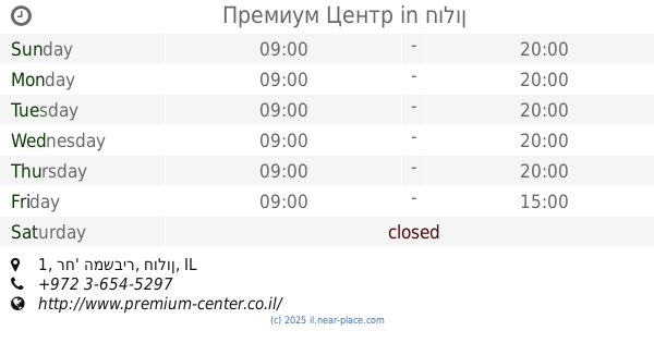
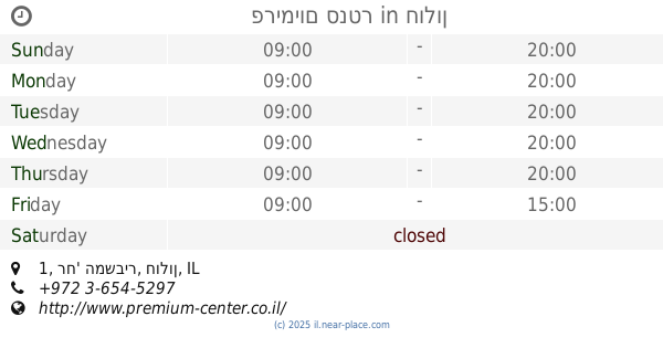
Премиум Центр
רח' המשביר 1, חולון
Shopping mall
read more
1.025 km
פרימיום סנטר
רח' המשביר 1, חולון
Shopping mall
read more
1.025 km
Premium Center
רח' המשביר 1, חולון
Shopping mall
read more
1.378 km
Msi
Ha-Banai Street 38, Holon
Shopping mall
read more
1.666 km
מרכז מסחרי בית חסם
חולון
Shopping mall
read more
2.034 km
Rangers center Holon Center
המרכבה 40, ת.ד. 1919, Holon
Shopping mall
read more
2.042 km
Саярим Центр
המרכבה 40 חולון IL 5811801, HaMerkava Street 40, Holon
Shopping mall
read more
2.042 km
מרכז הסיירים
המרכבה 40 חולון IL 5811801, המרכבה 40, חולון
Shopping mall
read more
2.042 km
מרכז הסיירים
המרכבה 40 חולון IL 5811801, HaMerkava Street 40, Holon
Shopping mall
read more
2.082 km
פרחים אלון חולון
הגדוד העברי 6, חולון
Shopping mall
read more
2.406 km
ליעד נגינה
Golda Me'ir Street 17-27, Holon
Shopping mall
read more
2.59 km
קניון עזריאלי חולון
גולדה מאיר 7, חולון
Shopping mall
read more
2.59 km
ТЦ Холон
Golda Me'ir Street 7, Holon
Shopping mall
read more
2.657 km
Holon Shopping Center
Golda Me'ir Street 7, Holon
Shopping mall
read more
3.497 km
בניין פנורמה
Derekh Ben-Zvi 84, Tel Aviv-Yafo
Shopping mall
read more
3.497 km
בניין פנורמה
דרך בן צבי 84, תל אביב יפו
Shopping mall
read more
3.741 km
חניון קרית רבין
חולון
Shopping mall
read more
📑
all categories
Accounting
Administrative area level 1
Administrative area level 2
Airport
Amusement park
Aquarium
Art gallery
Atm
Bakery
Bank
Bar
Beauty salon
Bicycle store
Book store
Bowling alley
Bus station
Cafe
Campground
Car dealer
Car rental
Car repair
Car wash
Casino
Cemetery
Church
City hall
Clothing store
Colloquial area
Convenience store
Country
Courthouse
Dentist
Department store
Doctor
Electrician
Electronics store
Embassy
Establishment
Finance
Fire station
Florist
Food
Funeral home
Furniture store
Gas station
General contractor
Grocery or supermarket
Gym
Hair care
Hardware store
Health
Hindu Temple
Home goods store
Hospital
Insurance agency
Intersection
Jewelry store
Laundry
Lawyer
Library
Light rail station
Liquor store
Local government office
Locality
Locksmith
Lodging
Meal delivery
Meal takeaway
Mosque
Movie rental
Movie theater
Moving company
Museum
Natural feature
Neighborhood
Night club
Painter
Park
Parking
Pet store
Pharmacy
Physiotherapist
Place of worship
Plumber
Point of interest
Police
Political
Post office
Premise
Real estate agency
Restaurant
Roofing contractor
Route
Rv park, camping
School
Shoe store
Shopping mall
Spa
Stadium
Storage
Store
Subpremise
Subway station
Supermarket
Synagogue
Taxi stand
Train station
Transit station
Travel agency
University
Veterinary care
Zoo
administrative area level 3
administrative area level 4
sublocality level 1
↑