Shopping mall nearby City Center
Israel
Shopping mall nearby City Center
City Center
Ma'alot-Tarshiha, Israel
contacts phone
:
+972
Latitude:
33.0136548
, Longitude:
35.2672356
larger map & directions
read more
nearest Shopping mall
מרכז מסחרי סיטי סנטר
מעלות תרשיחא
Shopping mall
read more
932 m
Assi Center Mall
Mi'ilya
Shopping mall
read more
1.008 km
Pets City
מעלות תרשיחא
Shopping mall
read more
1.289 km
Home Center
Ma'alot-Tarshiha
Shopping mall
read more
1.467 km
Local Market
Ma'alot-Tarshiha
Shopping mall
read more
1.467 km
מחסני כמעט חינם
מעלות תרשיחא
Shopping mall
read more
1.531 km
צים סנטר
כביש 89, מעלות תרשיחא
Shopping mall
read more
1.554 km
Urban Market
Ma'alot-Tarshiha
Shopping mall
read more
1.586 km
Zim Center Mall
David HaMelech Street 29, Ma'alot-Tarshiha
Shopping mall
read more
1.594 km
North Star Mall
Ma'alot-Tarshiha
Shopping mall
read more
1.938 km
Ha'rakafot Mall
Ma'alot-Tarshiha
Shopping mall
read more
2.143 km
Commercial Center Kfar Vradim
Kfar Vradim
Shopping mall
read more
3.616 km
Grocery Store
עין יעקב
Shopping mall
read more
3.616 km
Grocery Store
Ein Ya'akov
Shopping mall
read more
4.548 km
Grocery Store
Tzuriel
Shopping mall
read more
5.699 km
Grocery Store
גורן
Shopping mall
read more
7.031 km
Grocery Store
אילון
Shopping mall
read more
10.312 km
GAIA Center
ירכא
Shopping mall
read more
10.577 km
Dahar Shopping Center
Yarka
Shopping mall
read more
10.783 km
קניון כיכר העיר
כרמיאל
Shopping mall
read more
10.939 km
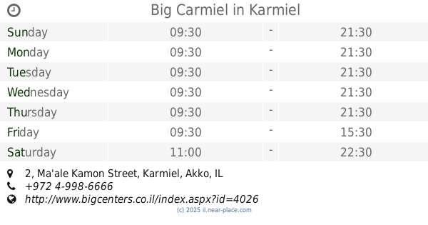
Big Carmiel
Ma'ale Kamon Street 2, Karmiel
Shopping mall
read more
10.948 km
קרולינה למקה כרמיאל
כרמיאל
Shopping mall
read more
11.759 km
מיובא מהנדסים
ארבל 13, כרמיאל
Shopping mall
read more
11.849 km
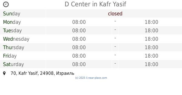
D Center
70, Kafr Yasif
Shopping mall
read more
12.752 km
נעלי וליאם איוב - נעלי המשפחה
ראמה
Shopping mall
read more
📑
all categories
Accounting
Administrative area level 1
Administrative area level 2
Airport
Amusement park
Aquarium
Art gallery
Atm
Bakery
Bank
Bar
Beauty salon
Bicycle store
Book store
Bowling alley
Bus station
Cafe
Campground
Car dealer
Car rental
Car repair
Car wash
Casino
Cemetery
Church
City hall
Clothing store
Colloquial area
Convenience store
Country
Courthouse
Dentist
Department store
Doctor
Electrician
Electronics store
Embassy
Establishment
Finance
Fire station
Florist
Food
Funeral home
Furniture store
Gas station
General contractor
Grocery or supermarket
Gym
Hair care
Hardware store
Health
Hindu Temple
Home goods store
Hospital
Insurance agency
Intersection
Jewelry store
Laundry
Lawyer
Library
Light rail station
Liquor store
Local government office
Locality
Locksmith
Lodging
Meal delivery
Meal takeaway
Mosque
Movie rental
Movie theater
Moving company
Museum
Natural feature
Neighborhood
Night club
Painter
Park
Parking
Pet store
Pharmacy
Physiotherapist
Place of worship
Plumber
Point of interest
Police
Political
Post office
Premise
Real estate agency
Restaurant
Roofing contractor
Route
Rv park, camping
School
Shoe store
Shopping mall
Spa
Stadium
Storage
Store
Subpremise
Subway station
Supermarket
Synagogue
Taxi stand
Train station
Transit station
Travel agency
University
Veterinary care
Zoo
administrative area level 3
administrative area level 4
sublocality level 1
↑