School nearby Shazar School
Israel
School nearby Shazar School
Shazar School
11, HaNotrim Street, Herzliya, IL Израиль
contacts phone
:
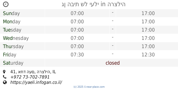
+972 9-956-3824
website:
www.shazar.herzliya.org.il
Latitude:
32.1661401
, Longitude:
34.8515184
larger map & directions
read more
nearest School
225 m
Ulpenat Tsviya
העצמאות 66, הרצליה
School
read more
258 m
Smart-Education Club הוראה פרטית משלימה
Sokolov Street 91, Herzliya
School
read more
304 m
Brenner School
Yigal Alon Street 42, Herzliya
School
read more
329 m
גן מורן - טרום טרום חובה
יגאל אלון 42, הרצליה
School
read more
451 m
התינוקיה של לי
קלישר, הרצליה
School
read more
532 m
גן הבית של יעלי
אחד העם 41, הרצליה
School
read more
567 m
גן צופית - גן עירייה
הרצוג 14, הרצליה
School
read more
654 m
Dor High School
Revivim Street 1, Herzliya
School
read more
743 m
Yohanani
Ha-Hagana Street 64, Herzliya
School
read more
743 m
ביס יוחנני
ההגנה 64, הרצליה
School
read more
798 m
משפחתון פזית
Hadar Street 51, Herzliya
School
read more
798 m
משפחתון פזית
הדר 51, הרצליה
School
read more
822 m
מקהלת לירון
שרה מלכין 15, הרצליה
School
read more
822 m
Li-ron Choir
Sara Malkin Street 15, Herzliya
School
read more
839 m
אריאל טנג'י - מתמטיקה , פיזיקה, חשמל ואלקטרוניקה
Beitar Street 38, Herzliya
School
read more
839 m
אריאל טנג'י - מתמטיקה , פיזיקה, חשמל ואלקטרוניקה
בית"ר 38, הרצליה
School
read more
950 m
המרכז להוראה מתקנת
Bar Ilan Street 15, Herzliya
School
read more
967 m
Wolfson
Mordei ha-Geta'ot Street 58, Herzliya
School
read more
968 m
תיכון דתי לחינוך ים וסביבה אחיה
הרצליה
School
read more
973 m
תיכון אחיה ממ"ד
הרצליה
School
read more
973 m
תיכון אחיה ממ"ד
Herzliya
School
read more
989 m
הבית של מילי
Anielewicz Street, Herzliya
School
read more
1.006 km
Wolfson School
Mordei ha-Geta'ot Street 58, Herzliya
School
read more
1.006 km
גן רבקי
Mordei ha-Geta'ot Street 58, Herzliya
School
read more
1.118 km
הגן של נאוה
שדרות בן גוריון 47, הרצליה
School
read more
📑
all categories
Accounting
Administrative area level 1
Administrative area level 2
Airport
Amusement park
Aquarium
Art gallery
Atm
Bakery
Bank
Bar
Beauty salon
Bicycle store
Book store
Bowling alley
Bus station
Cafe
Campground
Car dealer
Car rental
Car repair
Car wash
Casino
Cemetery
Church
City hall
Clothing store
Colloquial area
Convenience store
Country
Courthouse
Dentist
Department store
Doctor
Electrician
Electronics store
Embassy
Establishment
Finance
Fire station
Florist
Food
Funeral home
Furniture store
Gas station
General contractor
Grocery or supermarket
Gym
Hair care
Hardware store
Health
Hindu Temple
Home goods store
Hospital
Insurance agency
Intersection
Jewelry store
Laundry
Lawyer
Library
Light rail station
Liquor store
Local government office
Locality
Locksmith
Lodging
Meal delivery
Meal takeaway
Mosque
Movie rental
Movie theater
Moving company
Museum
Natural feature
Neighborhood
Night club
Painter
Park
Parking
Pet store
Pharmacy
Physiotherapist
Place of worship
Plumber
Point of interest
Police
Political
Post office
Premise
Real estate agency
Restaurant
Roofing contractor
Route
Rv park, camping
School
Shoe store
Shopping mall
Spa
Stadium
Storage
Store
Subpremise
Subway station
Supermarket
Synagogue
Taxi stand
Train station
Transit station
Travel agency
University
Veterinary care
Zoo
administrative area level 3
administrative area level 4
sublocality level 1
↑