School nearby Secondary workers
Coronavirus disease (COVID-19) Situation
confirmed cases
4841772
deaths
12707
Israel
School nearby Secondary workers
Secondary workers
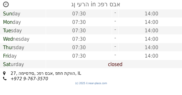
Kefar Sawa, Izrael
contacts phone
:
+972
Latitude:
32.1840973
, Longitude:
34.9067557
larger map & directions
read more
nearest School
תיכון עמל
כפר סבא
School
read more
219 m
Katznelson High School
Azar Street 43, Kefar Sava
School
read more
372 m
בית חינוך הרצוג
אז"ר 49, כפר סבא
School
read more
537 m
אגדת הגן
ניצנים 11, כפר סבא
School
read more
542 m
פעוטוני-צהרוני
Tchernichovsky Street 97, Kefar Sava
School
read more
621 m
גן חרצית
Kefar Sava
School
read more
621 m
גן חרצית
כפר סבא
School
read more
631 m
ביס מפתן
כפר סבא
School
read more
646 m
בית ספר עש הנריאטה סאלד
בר אילן 35, כפר סבא
School
read more
691 m
גן יצהר
כנפי נשרים, כפר סבא
School
read more
691 m
גן יצהר
Kanfei Nesharim Street, Kefar Sava
School
read more
714 m
גן דינה
המעפילים 18, כפר סבא
School
read more
714 m
גן דינה
HaMa'apilim Street 18, Kefar Sava
School
read more
734 m
גן יעלי
Rachel HaMeshoreret Street 19, Kefar Sava
School
read more
763 m
גן אביב
כפר סבא
School
read more
806 m
גן ימית
עציון 9, כפר סבא
School
read more
806 m
גן ימית
Etsyon Street 9, Kefar Sava
School
read more
873 m
קייטנת תורה בכפר בבר אילן כפר סבא
בר אילן 2, כפר סבא
School
read more
879 m
musical soul school
Golomb Street 31, Kefar Sava
School
read more
879 m
musical soul school
גולומב 31, כפר סבא
School
read more
996 m
אולפנית הראל
Tel-Hay Street 70, Kefar Sava
School
read more
998 m
גן יערה
המייסדים 27, כפר סבא
School
read more
1.011 km
גן נרקיס
המייסדים 25, כפר סבא
School
read more
1.077 km
חינוך לכל כיס
המייסדים 21, כפר סבא
School
read more
1.077 km
חינוך לכל כיס
Ha-Meyasdim Street 21, Kefar Sava
School
read more
📑
all categories
Accounting
Administrative area level 1
Administrative area level 2
Airport
Amusement park
Aquarium
Art gallery
Atm
Bakery
Bank
Bar
Beauty salon
Bicycle store
Book store
Bowling alley
Bus station
Cafe
Campground
Car dealer
Car rental
Car repair
Car wash
Casino
Cemetery
Church
City hall
Clothing store
Colloquial area
Convenience store
Country
Courthouse
Dentist
Department store
Doctor
Electrician
Electronics store
Embassy
Establishment
Finance
Fire station
Florist
Food
Funeral home
Furniture store
Gas station
General contractor
Grocery or supermarket
Gym
Hair care
Hardware store
Health
Hindu Temple
Home goods store
Hospital
Insurance agency
Intersection
Jewelry store
Laundry
Lawyer
Library
Light rail station
Liquor store
Local government office
Locality
Locksmith
Lodging
Meal delivery
Meal takeaway
Mosque
Movie rental
Movie theater
Moving company
Museum
Natural feature
Neighborhood
Night club
Painter
Park
Parking
Pet store
Pharmacy
Physiotherapist
Place of worship
Plumber
Point of interest
Police
Political
Post office
Premise
Real estate agency
Restaurant
Roofing contractor
Route
Rv park, camping
School
Shoe store
Shopping mall
Spa
Stadium
Storage
Store
Subpremise
Subway station
Supermarket
Synagogue
Taxi stand
Train station
Transit station
Travel agency
University
Veterinary care
Zoo
administrative area level 3
administrative area level 4
sublocality level 1
↑