School nearby School of Technology For Youth - Houra Place
Israel
School nearby School of Technology For Youth - Houra Place
School of Technology For Youth - Houra Place
Hura, Israel
contacts phone
:
+972
Latitude:
31.2957711
, Longitude:
34.9265229
larger map & directions
read more
nearest School
28 m
المدرسه التكنوجيه
Hura
School
read more
630 m
روضة الربيع
חורה
School
read more
686 m
כוכבי גן ילדים
אלעבאס 291, חורה
School
read more
686 m
כוכבי גן ילדים
Alabas Street 291, Hura
School
read more
807 m
ביס אל עטאונה
חורה
School
read more
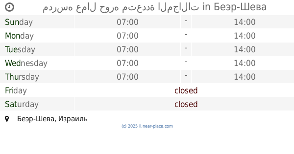
1.011 km
مدرسه عمال حوره متعددة المجالات
באר שבע
School
read more
1.011 km
مدرسه عمال حوره متعددة المجالات
Беэр-Шева
School
read more
1.029 km
Ahed School for Science
חורה
School
read more
1.071 km
בית ספר עהד למצוינות במדעים
Hura
School
read more
1.115 km
مدرسة النور حوره
Hura
School
read more
1.238 km
مدرسة الحياة
חורה
School
read more
1.322 km
יסודי א חורה, אלביאן
חורה
School
read more
1.333 km
مدرسة البيان الابتدائيه
חורה
School
read more
1.356 km
בית ספר אלאנדלוס
חורה שכונה 3, Hura
School
read more
1.364 km
Elementary school Alsiid Hafz
Israel
School
read more
1.441 km
בי"ס חורה לחינוך מיוחד
אלטויל 97, חורה
School
read more
1.664 km
روضة الاحلام
אלשאפעי 60, חורה
School
read more
1.808 km
מעון יום 9
Hura
School
read more
1.904 km
مدرسة السيد
Israel
School
read more
1.912 km
בית ספר אלמוסתקבל
חורה
School
read more
1.923 km
روضة الميثاق
אלאמל 98, חורה
School
read more
1.923 km
روضة الميثاق
Alamal Street 98, Hura
School
read more
2.196 km
בית הספר המקיף עמל אלסאלאם
חורה
School
read more
2.196 km
בית הספר המקיף עמל אלסאלאם
Hura
School
read more
2.224 km
مدرسة السلام الثانويه
חורה
School
read more
📑
all categories
Accounting
Administrative area level 1
Administrative area level 2
Airport
Amusement park
Aquarium
Art gallery
Atm
Bakery
Bank
Bar
Beauty salon
Bicycle store
Book store
Bowling alley
Bus station
Cafe
Campground
Car dealer
Car rental
Car repair
Car wash
Casino
Cemetery
Church
City hall
Clothing store
Colloquial area
Convenience store
Country
Courthouse
Dentist
Department store
Doctor
Electrician
Electronics store
Embassy
Establishment
Finance
Fire station
Florist
Food
Funeral home
Furniture store
Gas station
General contractor
Grocery or supermarket
Gym
Hair care
Hardware store
Health
Hindu Temple
Home goods store
Hospital
Insurance agency
Intersection
Jewelry store
Laundry
Lawyer
Library
Light rail station
Liquor store
Local government office
Locality
Locksmith
Lodging
Meal delivery
Meal takeaway
Mosque
Movie rental
Movie theater
Moving company
Museum
Natural feature
Neighborhood
Night club
Painter
Park
Parking
Pet store
Pharmacy
Physiotherapist
Place of worship
Plumber
Point of interest
Police
Political
Post office
Premise
Real estate agency
Restaurant
Roofing contractor
Route
Rv park, camping
School
Shoe store
Shopping mall
Spa
Stadium
Storage
Store
Subpremise
Subway station
Supermarket
Synagogue
Taxi stand
Train station
Transit station
Travel agency
University
Veterinary care
Zoo
administrative area level 3
administrative area level 4
sublocality level 1
↑