School nearby ProEnglish Language Coaching and Conversation
Coronavirus disease (COVID-19) Situation
confirmed cases
4841772
deaths
12707
Israel
School nearby ProEnglish Language Coaching and Conversation
ProEnglish Language Coaching and Conversation
Hovevei Tsiyon Street, Herzliya, Neve Amirim, הרצליה ישראל
contacts phone
:
+972
Latitude:
32.156088
, Longitude:
34.841348
read more
nearest School
ProEnglish Language Coaching and Conversation
Hovevei Tsiyon Street, Herzliya, Neve Amirim, Herzliya
School
read more
39 m
שיעורים פרטיים בהיסטוריה
Hovevei Tsiyon Street 14, Herzliya
School
read more
247 m
פלא בגן
Shirat Ge'ulim Street 7, Herzliya
School
read more
322 m
ביס לב טוב
רבי עקיבא 7, הרצליה
School
read more
393 m
הגן של נאוה
שדרות בן גוריון 47, הרצליה
School
read more
480 m
גן לי
סעדיה גאון 14, הרצליה
School
read more
480 m
גן לי
Se'adya Ga'on Street 14, Herzliya
School
read more
633 m
גן תומר
בר כוכבא 48, הרצליה
School
read more
653 m
Nativ School
Herzliya
School
read more
673 m
Rishonim High School
Herzliya
School
read more
707 m
עירוני כללי הראשונים
HaRav Kook Street 30, Herzliya
School
read more
729 m
מקהלת לירון
שרה מלכין 15, הרצליה
School
read more
807 m
גן סיגלית
לכיש 1, הרצליה
School
read more
807 m
גן סיגלית
Lakhish Street 1, Herzliya
School
read more
814 m
סיגלית/סנונית
שמאי 2, הרצליה
School
read more
814 m
סיגלית/סנונית
Shamai Street 2, Herzliya
School
read more
848 m
פעוטון רינה
HaAtsmaut Street 7, Herzliya
School
read more
855 m
ביס זאב חטב
Yehuda ha-Nasi Street 92, Herzliya
School
read more
870 m
גן מעונות שרה
Lakhish Street 13, Herzliya
School
read more
967 m
גן פופיק
ההגנה 14, רמת השרון
School
read more
1.058 km
גן חרצית
ארנון 17, רמת השרון
School
read more
1.058 km
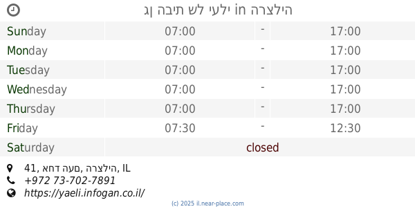
גן הבית של יעלי
אחד העם 41, הרצליה
School
read more
1.072 km
Weitzman School
Herzliya
School
read more
1.208 km
Kiryat yearim school
13, Yitskhak Elkhanan Street 11, Ramat Hasharon
School
read more
1.251 km
Ulpenat Tsviya
העצמאות 66, הרצליה
School
read more
📑
all categories
Accounting
Administrative area level 1
Administrative area level 2
Airport
Amusement park
Aquarium
Art gallery
Atm
Bakery
Bank
Bar
Beauty salon
Bicycle store
Book store
Bowling alley
Bus station
Cafe
Campground
Car dealer
Car rental
Car repair
Car wash
Casino
Cemetery
Church
City hall
Clothing store
Colloquial area
Convenience store
Country
Courthouse
Dentist
Department store
Doctor
Electrician
Electronics store
Embassy
Establishment
Finance
Fire station
Florist
Food
Funeral home
Furniture store
Gas station
General contractor
Grocery or supermarket
Gym
Hair care
Hardware store
Health
Hindu Temple
Home goods store
Hospital
Insurance agency
Intersection
Jewelry store
Laundry
Lawyer
Library
Light rail station
Liquor store
Local government office
Locality
Locksmith
Lodging
Meal delivery
Meal takeaway
Mosque
Movie rental
Movie theater
Moving company
Museum
Natural feature
Neighborhood
Night club
Painter
Park
Parking
Pet store
Pharmacy
Physiotherapist
Place of worship
Plumber
Point of interest
Police
Political
Post office
Premise
Real estate agency
Restaurant
Roofing contractor
Route
Rv park, camping
School
Shoe store
Shopping mall
Spa
Stadium
Storage
Store
Subpremise
Subway station
Supermarket
Synagogue
Taxi stand
Train station
Transit station
Travel agency
University
Veterinary care
Zoo
administrative area level 3
administrative area level 4
sublocality level 1
↑