School nearby مدرسة المتنبي الاعدادية.
Coronavirus disease (COVID-19) Situation
confirmed cases
4841772
deaths
12707
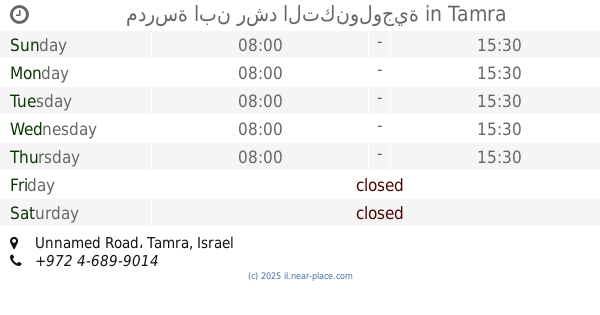
Israel
School nearby مدرسة المتنبي الاعدادية.
مدرسة المتنبي الاعدادية.
Тамра, Израиль
contacts phone
:
+972
Latitude:
32.8507489
, Longitude:
35.2138716
larger map & directions
read more
nearest School
مدرسة المتنبي الاعدادية.
טמרה
School
read more
143 m
בית ספר אלח׳וארזמי
טמרה
School
read more
148 m
בית ספר אלראזי ה
Tamra
School
read more
154 m
مدرسة الرازي
טמרה
School
read more
154 m
مدرسة الرازي
Tamra
School
read more
998 m
בית ספר אלבוכארי
Unnamed Road, Tamra
School
read more
1.029 km
مدرسة ز الابتدائية
Tamra
School
read more
1.029 km
مدرسة ز الابتدائية
טמרה
School
read more
1.185 km
مدرسه الشروق
Sa’edi Street, Tamra
School
read more
1.185 km
مدرسه الشروق
סעדי, טמרה
School
read more
1.185 km
مدرسة الخوارزمي
Tamra
School
read more
1.385 km
גני אלזוהור
טמרה
School
read more
1.385 km
גני אלזוהור
Tamra
School
read more
1.429 km
ביס אבן סינא ט'
טמרה
School
read more
1.834 km
Al-Bayan School
Tamra
School
read more
1.834 km
ביס אלביאן
טמרה
School
read more
2.005 km
Zahra c School
Tamra
School
read more
2.005 km
ביס אל זהרא ג'
טמרה
School
read more
2.022 km
בית ספר יסודי ב
כאבול
School
read more
2.022 km
In elementary school
Kabul
School
read more
2.029 km
ביס אל חדיקה
כאבול
School
read more
2.249 km
مدرسة ابن رشد التكنولوجية
Unnamed Road, Tamra
School
read more
2.422 km
D School
Tamra
School
read more
2.844 km
مدرسة البيروني
Tamra
School
read more
2.96 km
First Center
מדרסה זראעייה, Tamra
School
read more
📑
all categories
Accounting
Administrative area level 1
Administrative area level 2
Airport
Amusement park
Aquarium
Art gallery
Atm
Bakery
Bank
Bar
Beauty salon
Bicycle store
Book store
Bowling alley
Bus station
Cafe
Campground
Car dealer
Car rental
Car repair
Car wash
Casino
Cemetery
Church
City hall
Clothing store
Colloquial area
Convenience store
Country
Courthouse
Dentist
Department store
Doctor
Electrician
Electronics store
Embassy
Establishment
Finance
Fire station
Florist
Food
Funeral home
Furniture store
Gas station
General contractor
Grocery or supermarket
Gym
Hair care
Hardware store
Health
Hindu Temple
Home goods store
Hospital
Insurance agency
Intersection
Jewelry store
Laundry
Lawyer
Library
Light rail station
Liquor store
Local government office
Locality
Locksmith
Lodging
Meal delivery
Meal takeaway
Mosque
Movie rental
Movie theater
Moving company
Museum
Natural feature
Neighborhood
Night club
Painter
Park
Parking
Pet store
Pharmacy
Physiotherapist
Place of worship
Plumber
Point of interest
Police
Political
Post office
Premise
Real estate agency
Restaurant
Roofing contractor
Route
Rv park, camping
School
Shoe store
Shopping mall
Spa
Stadium
Storage
Store
Subpremise
Subway station
Supermarket
Synagogue
Taxi stand
Train station
Transit station
Travel agency
University
Veterinary care
Zoo
administrative area level 3
administrative area level 4
sublocality level 1
↑