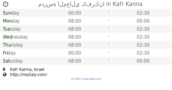
School nearby مدرسة المعالي الثانوية
Israel
School nearby مدرسة المعالي الثانوية
مدرسة المعالي الثانوية
כפר כנא, ישראל
contacts phone
:
+972
website:
www.maaly-hs.com
Latitude:
32.7409438
, Longitude:
35.3412651
larger map & directions
read more
nearest School
347 m
مدرسة المعالي كفركنا
Kafr Kanna
School
read more
514 m
روضة البراعم الاسلامية
Kafr Kanna
School
read more
514 m
روضة البراعم الاسلامية
כפר כנא
School
read more
574 m
סלון סומיה עבאס
Kafr Kanna
School
read more
691 m
كفركنا المدرسة الئبتدائية ج
Kafr Kanna
School
read more
842 m
משתלת בית חי
ישוב, Kafr Kanna
School
read more
842 m
משתלת בית חי
ישוב, כפר כנא
School
read more
900 m
בית ספר תיכון נזירות פרנססקניות
כפר כנא
School
read more
900 m
בית ספר תיכון נזירות פרנססקניות
Kafr Kanna
School
read more
995 m
المدرسة الإبتدائية ب "البيادر"
Kafr Kanna
School
read more
995 m
المدرسة الإبتدائية ب البيادر
כפר כנא
School
read more
1.443 km
גן סוניה
Livne Street 1, Nazareth Iliit
School
read more
1.443 km
גן סוניה
לבנה 1, נצרת עילית
School
read more
1.749 km
Ben Rushd High School
Kafr Kanna
School
read more
1.749 km
Ben Rushd High School
כפר כנא
School
read more
1.787 km
Кфар Кана
Unnamed Rd,, Kafr Kanna
School
read more
1.793 km
בית ספר אלאמל
Mashhad
School
read more
1.819 km
مدرسة جبل سيخ الإبتدائية
Ein Mahil
School
read more
1.819 km
مدرسة جبل سيخ الإبتدائية
עין מאהל
School
read more
1.832 km
תיכון עין מאהל
עין מאהל
School
read more
1.886 km
ישיבה תיכונית אורט נצרת עילית
Yaqinton Street 7, Nazareth Iliit
School
read more
1.906 km
מעון יום נעמת עדעד
Ad'ad Street 17, Nazareth Iliit
School
read more
1.906 km
מעון יום נעמ"ת עדעד
עדעד 17, נצרת עילית
School
read more
2.692 km
בית ספר תיכון ריינה
Reineh
School
read more
3.417 km
معهد أهداف
ריינה
School
read more
📑
all categories
Accounting
Administrative area level 1
Administrative area level 2
Airport
Amusement park
Aquarium
Art gallery
Atm
Bakery
Bank
Bar
Beauty salon
Bicycle store
Book store
Bowling alley
Bus station
Cafe
Campground
Car dealer
Car rental
Car repair
Car wash
Casino
Cemetery
Church
City hall
Clothing store
Colloquial area
Convenience store
Country
Courthouse
Dentist
Department store
Doctor
Electrician
Electronics store
Embassy
Establishment
Finance
Fire station
Florist
Food
Funeral home
Furniture store
Gas station
General contractor
Grocery or supermarket
Gym
Hair care
Hardware store
Health
Hindu Temple
Home goods store
Hospital
Insurance agency
Intersection
Jewelry store
Laundry
Lawyer
Library
Light rail station
Liquor store
Local government office
Locality
Locksmith
Lodging
Meal delivery
Meal takeaway
Mosque
Movie rental
Movie theater
Moving company
Museum
Natural feature
Neighborhood
Night club
Painter
Park
Parking
Pet store
Pharmacy
Physiotherapist
Place of worship
Plumber
Point of interest
Police
Political
Post office
Premise
Real estate agency
Restaurant
Roofing contractor
Route
Rv park, camping
School
Shoe store
Shopping mall
Spa
Stadium
Storage
Store
Subpremise
Subway station
Supermarket
Synagogue
Taxi stand
Train station
Transit station
Travel agency
University
Veterinary care
Zoo
administrative area level 3
administrative area level 4
sublocality level 1
↑