School nearby Levinson High School
Israel
School nearby Levinson High School
Levinson High School
23, Sderot Tsahal, Kiryat Yam, Haifa, IL Израиль
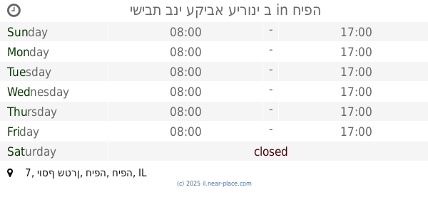
contacts phone
:
+972 4-876-1517
Latitude:
32.8474093
, Longitude:
35.0641381
larger map & directions
read more
nearest School
340 m
גן גפן
Sderot Moshe Sharet 18, Kiryat Yam
School
read more
340 m
גן תאנה
Sderot Moshe Sharet 18, Kiryat Yam
School
read more
493 m
בית ספר אמירים
Kiryat Yam
School
read more
501 m
גן רותם
אלי כהן 16, קרית ים
School
read more
501 m
גן רותם
Eli Cohen Street 16, Kiryat Yam
School
read more
510 m
גן חמנית
HaNa'aman Street 6, Kiryat Yam
School
read more
527 m
גן צבר
Ha-Rishonim Street 6, Kiryat Yam
School
read more
555 m
גן אלון
Alon Street 2, Kiryat Yam
School
read more
581 m
גן תומר
גיורא יוספטל 26, קרית ים
School
read more
713 m
גן שיזף
Yisra'el Yesha'ayahu Street 4, Kiryat Yam
School
read more
768 m
גן ברוש
יצחק בן צבי 28, קרית ים
School
read more
773 m
גן הרדוף
שדרות הרצל 85, קרית ים
School
read more
816 m
גן צבעוני
שדרות הרצל 71, קרית ים
School
read more
816 m
גן ניצן
שדרות הרצל 71, קרית ים
School
read more
843 m
גן עירית
Y.L. Perets Street 24, Kiryat Yam
School
read more
844 m
גן יקינטון
Y.L. Perets Street 24, Kiryat Yam
School
read more
862 m
Chabad School Boys
HaRav Arye Levin Street 3, Haifa
School
read more
892 m
בית ספר חבד תלמוד תורה צבאות מנחם
הרב אריה לוין 1, חיפה
School
read more
941 m
Talmud Torah Beth Jacob Netivot Moshe
Kdoshei HaShoa Street 13-19, Haifa
School
read more
1.025 km
ישיבת בני עקיבא עירוני ב
יוסף שטרן 7, חיפה
School
read more
1.031 km
גן כוכב
HaRambam Street 16, Kiryat Yam
School
read more
1.033 km
ביס חבד לבנות בית חיה
חיפה
School
read more
1.088 km
גן סחלב
Tamar Street 2, Kiryat Yam
School
read more
1.235 km
בה"ס אלמוגים
רח' אצל 10, קרית ים
School
read more
1.235 km
Школа Альмогим
רח' אצל 10, קרית ים
School
read more
📑
all categories
Accounting
Administrative area level 1
Administrative area level 2
Airport
Amusement park
Aquarium
Art gallery
Atm
Bakery
Bank
Bar
Beauty salon
Bicycle store
Book store
Bowling alley
Bus station
Cafe
Campground
Car dealer
Car rental
Car repair
Car wash
Casino
Cemetery
Church
City hall
Clothing store
Colloquial area
Convenience store
Country
Courthouse
Dentist
Department store
Doctor
Electrician
Electronics store
Embassy
Establishment
Finance
Fire station
Florist
Food
Funeral home
Furniture store
Gas station
General contractor
Grocery or supermarket
Gym
Hair care
Hardware store
Health
Hindu Temple
Home goods store
Hospital
Insurance agency
Intersection
Jewelry store
Laundry
Lawyer
Library
Light rail station
Liquor store
Local government office
Locality
Locksmith
Lodging
Meal delivery
Meal takeaway
Mosque
Movie rental
Movie theater
Moving company
Museum
Natural feature
Neighborhood
Night club
Painter
Park
Parking
Pet store
Pharmacy
Physiotherapist
Place of worship
Plumber
Point of interest
Police
Political
Post office
Premise
Real estate agency
Restaurant
Roofing contractor
Route
Rv park, camping
School
Shoe store
Shopping mall
Spa
Stadium
Storage
Store
Subpremise
Subway station
Supermarket
Synagogue
Taxi stand
Train station
Transit station
Travel agency
University
Veterinary care
Zoo
administrative area level 3
administrative area level 4
sublocality level 1
↑