School nearby חווה חקלאית ולימודי סביבה טמרה
Israel
School nearby חווה חקלאית ולימודי סביבה טמרה
חווה חקלאית ולימודי סביבה טמרה
טמרה, ישראל
contacts phone
:
+972
Latitude:
32.862757
, Longitude:
35.1837326
larger map & directions
read more
nearest School
325 m
First Center
מדרסה זראעייה, Tamra
School
read more
386 m
Albyrone school בית ספר אלבירוני טמרה
טמרה
School
read more
410 m
مدرسة البيروني
Tamra
School
read more
410 m
ביס ח' - אלביירוני
טמרה
School
read more
479 m
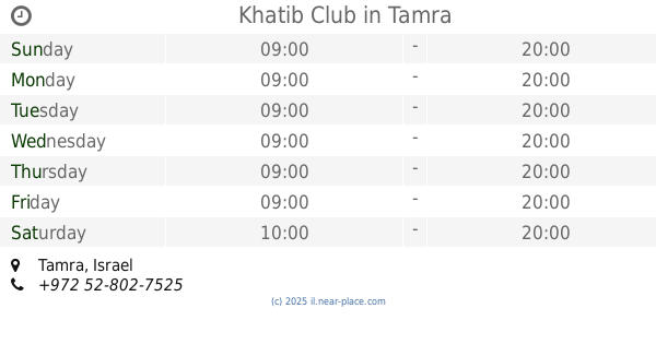
מועדון חטיב
טמרה
School
read more
479 m
Khatib Club
Tamra
School
read more
761 m
School Algzali D.
Tamra
School
read more
770 m
D School
Tamra
School
read more
955 m
Muftan School
Tamra
School
read more
1.134 km
ביס אל זהרא ג'
טמרה
School
read more
1.134 km
Zahra c School
Tamra
School
read more
1.319 km
ביס אלביאן
טמרה
School
read more
1.389 km
skills 21
טמרה
School
read more
1.421 km
مدرسة ابن رشد التكنولوجية
Unnamed Road, Tamra
School
read more
1.511 km
Talented Student Center
Tamra
School
read more
1.583 km
Center for Talented and Gifted Students
אשכול פיס, Tamra
School
read more
1.583 km
מרכז למחוננים ומצטיינים
אשכול פיס, טמרה
School
read more
1.693 km
תיכון כאבול- ثانوية كابول
כאבול
School
read more
1.699 km
ביס אבן סינא ט'
טמרה
School
read more
1.7 km
المدرسة الثانوية-תיכון
Kabul
School
read more
2.015 km
مدرسه الشروق
Sa’edi Street, Tamra
School
read more
2.015 km
مدرسه الشروق
סעדי, טמרה
School
read more
2.082 km
D school
כאבול
School
read more
2.5 km
בית ספר אלבוכארי
Unnamed Road, Tamra
School
read more
2.507 km
مدرسة ز الابتدائية
Tamra
School
read more
📑
all categories
Accounting
Administrative area level 1
Administrative area level 2
Airport
Amusement park
Aquarium
Art gallery
Atm
Bakery
Bank
Bar
Beauty salon
Bicycle store
Book store
Bowling alley
Bus station
Cafe
Campground
Car dealer
Car rental
Car repair
Car wash
Casino
Cemetery
Church
City hall
Clothing store
Colloquial area
Convenience store
Country
Courthouse
Dentist
Department store
Doctor
Electrician
Electronics store
Embassy
Establishment
Finance
Fire station
Florist
Food
Funeral home
Furniture store
Gas station
General contractor
Grocery or supermarket
Gym
Hair care
Hardware store
Health
Hindu Temple
Home goods store
Hospital
Insurance agency
Intersection
Jewelry store
Laundry
Lawyer
Library
Light rail station
Liquor store
Local government office
Locality
Locksmith
Lodging
Meal delivery
Meal takeaway
Mosque
Movie rental
Movie theater
Moving company
Museum
Natural feature
Neighborhood
Night club
Painter
Park
Parking
Pet store
Pharmacy
Physiotherapist
Place of worship
Plumber
Point of interest
Police
Political
Post office
Premise
Real estate agency
Restaurant
Roofing contractor
Route
Rv park, camping
School
Shoe store
Shopping mall
Spa
Stadium
Storage
Store
Subpremise
Subway station
Supermarket
Synagogue
Taxi stand
Train station
Transit station
Travel agency
University
Veterinary care
Zoo
administrative area level 3
administrative area level 4
sublocality level 1
↑