School nearby אהלי ספר בנות
Israel
School nearby אהלי ספר בנות
אהלי ספר בנות
Or Ha'chayim Street, Modi'in Ilit Израиль
contacts phone
:
+972
Latitude:
31.930676
, Longitude:
35.04013
read more
nearest School
אהלי ספר בנות
אור החיים, מודיעין עילית
School
read more
78 m
תלמוד תורה אהלי ספר
Or Ha'chayim Street 27, Modi'in Ilit
School
read more
78 m
תלמוד תורה אהלי ספר
אור החיים 27, מודיעין עילית
School
read more
84 m
Ohalei Sefer School
Or Ha'chayim Street 27, Modi'in Ilit
School
read more
84 m
בי"ס אוהלי ספר- בנים
אור החיים 27, מודיעין עילית
School
read more
361 m
גני עץ הדעת
31°55'44.9"N 35°02'36.6"E
School
read more
362 m
תלמוד תורה מאיר עיניים
Mesilat Yesharim Street, Modi'in Ilit
School
read more
776 m
בית כנסת קול יעקב
נתיבות המשפט 7, מודיעין עילית
School
read more
776 m
בית כנסת קול יעקב
Netivot HaMishpat 7, Modi'in Ilit
School
read more
790 m
תת קרית ספר
מודיעין עילית
School
read more
790 m
תת קרית ספר
Modi'in Ilit
School
read more
838 m
תלמוד תורה החינוך
20, Sha'arei Tshuva Street, Modi'in Ilit
School
read more
854 m
טף לטף - בית ספר לחינוך מיוחד
31.9308968, 35.0491851
School
read more
1.069 km
Preparatory Yeshiva Nahalat Shimon
Rav ve-Shmu'el Street, Modi'in Ilit
School
read more
1.069 km
מכינה לישיבה נחלת שמעון
רב ושמואל, מודיעין עילית
School
read more
1.146 km
Talmud Torah Torah property
Rav ve-Shmu'el Street 11, Modi'in Ilit
School
read more
1.146 km
תלמוד תורה קנין התורה
רב ושמואל 11, מודיעין עילית
School
read more
1.214 km
ביס אור
כפר האורנים
School
read more
1.214 km
Orr School
Kfar Ha-Oranim
School
read more
2.175 km
בית ספר "למען אחי"
בית ירדן 7, לפיד
School
read more
2.256 km
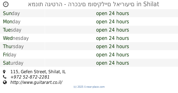
אמנות הגיטרה - הרכבים מוסיקליים לאירועים
Gefen Street 115, Shilat
School
read more
2.493 km
مدرسة نعلين الحديثة (المختلطة )
نعلين الشارع الجديد
School
read more
2.637 km
مدرسة اناث نعلين
Nuzha Street, Dhahran
School
read more
3.148 km
בית ספר יזמה
מודיעין מכבים רעות
School
read more
3.535 km
ביס האלה
שדרות עמק האלה 40, מודיעין מכבים רעות
School
read more
📑
all categories
Accounting
Administrative area level 1
Administrative area level 2
Airport
Amusement park
Aquarium
Art gallery
Atm
Bakery
Bank
Bar
Beauty salon
Bicycle store
Book store
Bowling alley
Bus station
Cafe
Campground
Car dealer
Car rental
Car repair
Car wash
Casino
Cemetery
Church
City hall
Clothing store
Colloquial area
Convenience store
Country
Courthouse
Dentist
Department store
Doctor
Electrician
Electronics store
Embassy
Establishment
Finance
Fire station
Florist
Food
Funeral home
Furniture store
Gas station
General contractor
Grocery or supermarket
Gym
Hair care
Hardware store
Health
Hindu Temple
Home goods store
Hospital
Insurance agency
Intersection
Jewelry store
Laundry
Lawyer
Library
Light rail station
Liquor store
Local government office
Locality
Locksmith
Lodging
Meal delivery
Meal takeaway
Mosque
Movie rental
Movie theater
Moving company
Museum
Natural feature
Neighborhood
Night club
Painter
Park
Parking
Pet store
Pharmacy
Physiotherapist
Place of worship
Plumber
Point of interest
Police
Political
Post office
Premise
Real estate agency
Restaurant
Roofing contractor
Route
Rv park, camping
School
Shoe store
Shopping mall
Spa
Stadium
Storage
Store
Subpremise
Subway station
Supermarket
Synagogue
Taxi stand
Train station
Transit station
Travel agency
University
Veterinary care
Zoo
administrative area level 3
administrative area level 4
sublocality level 1
↑