School nearby Haj Rab'i Elementary School for Girls
Israel
School nearby Haj Rab'i Elementary School for Girls
Haj Rab'i Elementary School for Girls
הגדה המערבית
contacts phone
:
+972
Latitude:
31.5321319
, Longitude:
35.0697387
larger map & directions
read more
nearest School
734 m
مدرسة بيسان الأساسية للبنات
Al Lawzah, Riyadh
School
read more
738 m
مدرسة بيسان الأساسية للبنات
31.527974,35.063299
School
read more
930 m
مدرسة سيدنا إبراهيم
Isa Drive Southeast, Atlanta
School
read more
1.292 km
مدرسة السيدة سارة
Khaleel El-Masry
School
read more
1.857 km
Male secondary school legitimacy
الحاوز الاول الخليل،
School
read more
1.875 km
الجمعية الخيرية الإسلامية للبنات
Al Salam Street, Abu Dhabi
School
read more
1.958 km
مدرسة حكمت للبنين
شارع الحاووز الأول بجانب مدرسة الشافعي
School
read more
2.029 km
مدرسة الشافعي للبنين
شارع الحاووز الأول بجانب مركز شرطة الحاووز
School
read more
2.041 km
School Prince Mohammed basic Hebron
وادي التفاح,الخليل
School
read more
2.275 km
مدرسة الحاجة نظيرة ابو رميلة
School
read more
2.497 km
Granada School for Girls
חברון, אריאל
School
read more
2.852 km
La Casa Learning Center
Ein Sarah Street Hebron
School
read more
2.878 km
مدرسة محمود ابو غزاله للبنين
West Harry Street, Cranston
School
read more
2.887 km
مدرسة القدس المختلطة
Yafa
School
read more
2.897 km
Alhussain Bin Ali School
Sara Street, Doha
School
read more
2.916 km
The Excellence Center in Palestine
Ein Sarah Street, Next to Al Hussein Mosque, Hebron
Lodging
Travel agency
School
Point of interest
Establishment
read more
2.921 km
Alhussain Ben Ali Secondary School
Ain Sarah, Hebron
School
read more
2.957 km
School of the pioneers of knowledge of excellence
Hebron Street, Ari'el
School
read more
2.957 km
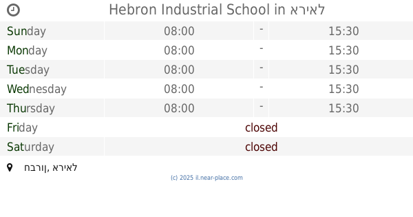
Hebron Industrial School
חברון, אריאל
School
read more
2.996 km
جمعية الكشافة الفلسطينية - مفوضية كشافة محافظة الخليل Palestinian Scout Association , Hebron.Scout Commission
الخليل، شارع عين سارة، عمارة الجمل ، طابق ٣
School
read more
3.045 km
مدرسة الفاروق الاساسية للبنين
Abu Haruba Street, Shibli-Umm al-Ghanam
School
read more
3.045 km
مدرسة الفاروق الاساسية للبنين
אבו ח'רובה, שבלי - אום אל-גנם
School
read more
3.462 km
Fatima School Dkidk
Aljora Street, Daburiyya
School
read more
3.597 km
Rushdeyah Mohtaseb School
Hebron
School
read more
3.602 km
مدرسة رشدية المحتسب
As Sahafa Street
School
read more
📑
all categories
Accounting
Administrative area level 1
Administrative area level 2
Airport
Amusement park
Aquarium
Art gallery
Atm
Bakery
Bank
Bar
Beauty salon
Bicycle store
Book store
Bowling alley
Bus station
Cafe
Campground
Car dealer
Car rental
Car repair
Car wash
Casino
Cemetery
Church
City hall
Clothing store
Colloquial area
Convenience store
Country
Courthouse
Dentist
Department store
Doctor
Electrician
Electronics store
Embassy
Establishment
Finance
Fire station
Florist
Food
Funeral home
Furniture store
Gas station
General contractor
Grocery or supermarket
Gym
Hair care
Hardware store
Health
Hindu Temple
Home goods store
Hospital
Insurance agency
Intersection
Jewelry store
Laundry
Lawyer
Library
Light rail station
Liquor store
Local government office
Locality
Locksmith
Lodging
Meal delivery
Meal takeaway
Mosque
Movie rental
Movie theater
Moving company
Museum
Natural feature
Neighborhood
Night club
Painter
Park
Parking
Pet store
Pharmacy
Physiotherapist
Place of worship
Plumber
Point of interest
Police
Political
Post office
Premise
Real estate agency
Restaurant
Roofing contractor
Route
Rv park, camping
School
Shoe store
Shopping mall
Spa
Stadium
Storage
Store
Subpremise
Subway station
Supermarket
Synagogue
Taxi stand
Train station
Transit station
Travel agency
University
Veterinary care
Zoo
administrative area level 3
administrative area level 4
sublocality level 1
↑