School nearby גן פטל וגן ניצן
Israel
School nearby גן פטל וגן ניצן
גן פטל וגן ניצן
32-34, פורצי הדרך, הרצליה, IL ישראל
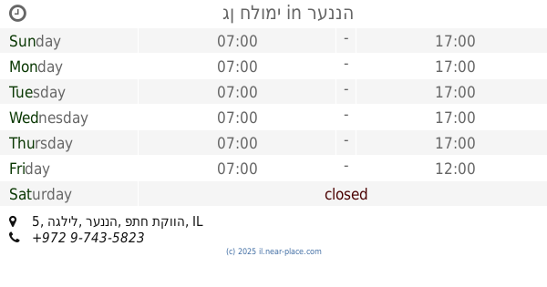
contacts phone
:
+972
Latitude:
32.1642905
, Longitude:
34.8628361
larger map & directions
read more
nearest School
גן פטל וגן ניצן
Portsei HaDerech 32-34, Herzliya
School
read more
466 m
Green Garden
Kibuts Galuyot Street 100, Herzliya
School
read more
497 m
בא לי גן
Yeziat Europa Street 38, Herzliya
School
read more
620 m
גן בוסתן
Simtat Yefet Ben Zakhariya Meged 58, Herzliya
School
read more
620 m
גן בוסתן
סמטת יפת בן זכריה מגד 58, הרצליה
School
read more
649 m
Wolfson
Mordei ha-Geta'ot Street 58, Herzliya
School
read more
650 m
Gordon School
Herzliya
School
read more
664 m
Wolfson School
Mordei ha-Geta'ot Street 58, Herzliya
School
read more
664 m
גן רבקי
Mordei ha-Geta'ot Street 58, Herzliya
School
read more
1.119 km
Dor High School
Revivim Street 1, Herzliya
School
read more
1.151 km
גן בית בטבע - יריב אביב
ברכת עם, גבעת חן
School
read more
1.179 km
אריאל טנג'י - מתמטיקה , פיזיקה, חשמל ואלקטרוניקה
Beitar Street 38, Herzliya
School
read more
1.179 km
אריאל טנג'י - מתמטיקה , פיזיקה, חשמל ואלקטרוניקה
בית"ר 38, הרצליה
School
read more
1.2 km
תיכון אחיה ממ"ד
Herzliya
School
read more
1.268 km
גן מורן - טרום טרום חובה
יגאל אלון 42, הרצליה
School
read more
1.298 km
Tut Kindegarden
Herzl Street 86, Ra'anana
School
read more
1.397 km
גן האפרוחים של ליזי וגילי
Pardes Meshutaf Street 5, Ra'anana
School
read more
1.653 km
משפחתון פזית
הדר 51, הרצליה
School
read more
1.697 km
Bilu School
Bilu Street 15, Ra'anana
School
read more
1.895 km
בית ספר פעמונים רעננה
הפעמונים 11, רעננה
School
read more
1.944 km
גן ילדים "אורגניל'ה"
Opsterland Street 5, Ra'anana
School
read more
2.008 km
Tali School Raanana
Ha-Prakhim Street 21, Ra'anana
School
read more
2.061 km
Ankori high school
Ahuza Street 148, Ra'anana
School
read more
2.283 km
גן חלומי
הגליל 5, רעננה
School
read more
2.359 km
המכון לאמיתות התורה
Ahuza Street 68, Ra'anana
School
read more
📑
all categories
Accounting
Administrative area level 1
Administrative area level 2
Airport
Amusement park
Aquarium
Art gallery
Atm
Bakery
Bank
Bar
Beauty salon
Bicycle store
Book store
Bowling alley
Bus station
Cafe
Campground
Car dealer
Car rental
Car repair
Car wash
Casino
Cemetery
Church
City hall
Clothing store
Colloquial area
Convenience store
Country
Courthouse
Dentist
Department store
Doctor
Electrician
Electronics store
Embassy
Establishment
Finance
Fire station
Florist
Food
Funeral home
Furniture store
Gas station
General contractor
Grocery or supermarket
Gym
Hair care
Hardware store
Health
Hindu Temple
Home goods store
Hospital
Insurance agency
Intersection
Jewelry store
Laundry
Lawyer
Library
Light rail station
Liquor store
Local government office
Locality
Locksmith
Lodging
Meal delivery
Meal takeaway
Mosque
Movie rental
Movie theater
Moving company
Museum
Natural feature
Neighborhood
Night club
Painter
Park
Parking
Pet store
Pharmacy
Physiotherapist
Place of worship
Plumber
Point of interest
Police
Political
Post office
Premise
Real estate agency
Restaurant
Roofing contractor
Route
Rv park, camping
School
Shoe store
Shopping mall
Spa
Stadium
Storage
Store
Subpremise
Subway station
Supermarket
Synagogue
Taxi stand
Train station
Transit station
Travel agency
University
Veterinary care
Zoo
administrative area level 3
administrative area level 4
sublocality level 1
↑