School nearby גן מנדי
Israel
School nearby גן מנדי
גן מנדי
23-35, שאול, חיפה, חיפה, IL ישראל
contacts phone
:
+972 52-647-0970
website:
www.facebook.com
Latitude:
32.7883653
, Longitude:
35.0168848
larger map & directions
read more
nearest School
311 m
בית ספר "ביחד"
3, Mitspe Street, Haifa
School
read more
409 m
Tel Hai School
HaGalil Street 107, Haifa
School
read more
409 m
ביס תל חי
הגליל 107, חיפה
School
read more
421 m
הגן של רענן
רות הכהן 8, חיפה
School
read more
459 m
Школа Израэлия
Cherniavski Street 3-7, Haifa
School
read more
459 m
Школа Израэлия
צ'רניאבסקי 3-7, חיפה
School
read more
488 m
בית הספר יזרעאליה
צ'רניאבסקי 3-7, חיפה
School
read more
488 m
גן יונית
Sderot Trumpeldor 38, Haifa
School
read more
496 m
גן רונית
Sderot Trumpeldor 37, Haifa
School
read more
515 m
גן מנדי
52,, Sderot Trumpeldor 40, Haifa
School
read more
536 m
גן דבורה
53,, Sderot Trumpeldor 39, Haifa
School
read more
642 m
גן ילדים חתלתול
Ha-Tikhon Street 8, Haifa
School
read more
780 m
גן בלומה
א.ד. גורדון 26, חיפה
School
read more
780 m
גן בלומה
A.D. Gordon Street 26, Haifa
School
read more
789 m
ביס דינור
יעקב קליבנוב 20, חיפה
School
read more
811 m
מעון ויצו נווה שאנן חיפה
HaRav Maimon Street 31, Haifa
School
read more
868 m
גן אלומות
יעקב קליבנוב 35-37, חיפה
School
read more
874 m
גן ממד אלומות
Ya'akov Klivanov Street 26, Haifa
School
read more
967 m
Ванюшина школа
יעקב קליבנוב 2, חיפה
School
read more
983 m
Rimonim Workroom
הרב מיימון 43, חיפה
School
read more
983 m
Rimonim Workroom
HaRav Maimon Street 43, Haifa
School
read more
1.035 km
ביחד גן ילדים
אינטרנציונל 3, חיפה
School
read more
1.083 km
אורות חיפה ביהס להתעמלות
מתנס, HaBonim
School
read more
1.085 km
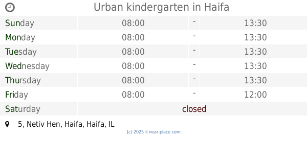
Urban kindergarten
Netiv Hen 5, Haifa
School
read more
1.216 km
Habonim School
Haifa
School
read more
📑
all categories
Accounting
Administrative area level 1
Administrative area level 2
Airport
Amusement park
Aquarium
Art gallery
Atm
Bakery
Bank
Bar
Beauty salon
Bicycle store
Book store
Bowling alley
Bus station
Cafe
Campground
Car dealer
Car rental
Car repair
Car wash
Casino
Cemetery
Church
City hall
Clothing store
Colloquial area
Convenience store
Country
Courthouse
Dentist
Department store
Doctor
Electrician
Electronics store
Embassy
Establishment
Finance
Fire station
Florist
Food
Funeral home
Furniture store
Gas station
General contractor
Grocery or supermarket
Gym
Hair care
Hardware store
Health
Hindu Temple
Home goods store
Hospital
Insurance agency
Intersection
Jewelry store
Laundry
Lawyer
Library
Light rail station
Liquor store
Local government office
Locality
Locksmith
Lodging
Meal delivery
Meal takeaway
Mosque
Movie rental
Movie theater
Moving company
Museum
Natural feature
Neighborhood
Night club
Painter
Park
Parking
Pet store
Pharmacy
Physiotherapist
Place of worship
Plumber
Point of interest
Police
Political
Post office
Premise
Real estate agency
Restaurant
Roofing contractor
Route
Rv park, camping
School
Shoe store
Shopping mall
Spa
Stadium
Storage
Store
Subpremise
Subway station
Supermarket
Synagogue
Taxi stand
Train station
Transit station
Travel agency
University
Veterinary care
Zoo
administrative area level 3
administrative area level 4
sublocality level 1
↑