School nearby Druzechef
Israel
School nearby Druzechef
Druzechef
druzechef, Daliyat el-Carmel, Израиль
contacts phone
:
+972 53-395-3753
website:
www.druzechef.com
Latitude:
32.6872178
, Longitude:
35.0504134
larger map & directions
read more
nearest School
1.089 km
جمعية فأس التعاونية
672, Daliyat al-Karmel
School
read more
1.799 km
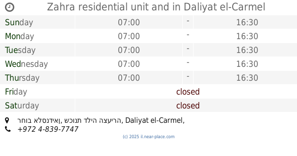
Zahra residential unit and
רחוב אלסנדיאן, שכונת דליה הצעירה, Daliyat al-Karmel
School
read more
2.092 km
בית ספר יסודי אלאשראק
Isfiya
School
read more
2.092 km
בית ספר יסודי אלאשראק
עיספיא
School
read more
2.1 km
בית ספר יסודי א עוספיא
עוספיא, Isfiya
School
read more
2.134 km
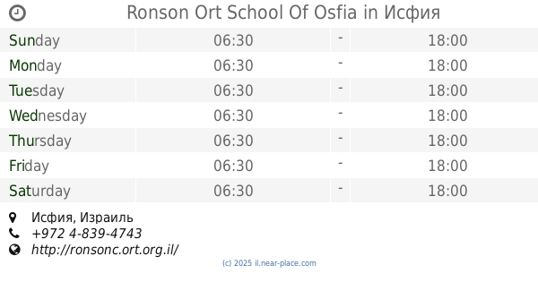
Ronson Ort School Of Osfia
Isfiya
School
read more
2.224 km
בית ספר עתיד טכנולוגי
Daliyat al-Karmel
School
read more
2.224 km
בית ספר עתיד טכנולוגי
דאלית אל-כרמל
School
read more
2.237 km
בית ספר חטב אלאשראק
Isfiya
School
read more
2.516 km
בית ספר אורט רונסון
Isfiya
School
read more
3.431 km
حضانة ليوشاגן ליושה
Isfiya
School
read more
3.752 km
אולם ספורט מקורה
עיספיא
School
read more
3.752 km
Indoor sports hall
Isfiya
School
read more
3.77 km
בית ספר אורט חטה עספייא
Isfiya
School
read more
3.887 km
מרכז אנגלית קטרינה מארון
Isfiya
School
read more
3.887 km
מרכז אנגלית קטרינה מארון
עיספיא
School
read more
4.294 km
בית ספר מסא
Unnamed Road, עיספיא
School
read more
4.294 km
בית ספר מס"א
Unnamed Road, Isfiya
School
read more
6.063 km
משפחתון קטנטנים יקנעם עילית
HaRakafot Street 5, Yokne'am Illit
School
read more
6.063 km
משפחתון קטנטנים יקנעם עילית
הרקפות 5, יוקנעם עילית
School
read more
6.099 km
ביס ארזים
רחוב אלונים 31, יוקנעם עילית
School
read more
6.107 km
גן ילדים אופירה, גן ילדים לוטם
האלונים 15, יוקנעם עילית
School
read more
6.107 km
גן ילדים אופירה, גן ילדים לוטם
Ha-Alonim Street 15, Yokne'am Illit
School
read more
11.221 km
גן רונית
Sderot Trumpeldor 37, Haifa
School
read more
12.604 km
גן ארזים
שדרות סיני 9, חיפה
School
read more
📑
all categories
Accounting
Administrative area level 1
Administrative area level 2
Airport
Amusement park
Aquarium
Art gallery
Atm
Bakery
Bank
Bar
Beauty salon
Bicycle store
Book store
Bowling alley
Bus station
Cafe
Campground
Car dealer
Car rental
Car repair
Car wash
Casino
Cemetery
Church
City hall
Clothing store
Colloquial area
Convenience store
Country
Courthouse
Dentist
Department store
Doctor
Electrician
Electronics store
Embassy
Establishment
Finance
Fire station
Florist
Food
Funeral home
Furniture store
Gas station
General contractor
Grocery or supermarket
Gym
Hair care
Hardware store
Health
Hindu Temple
Home goods store
Hospital
Insurance agency
Intersection
Jewelry store
Laundry
Lawyer
Library
Light rail station
Liquor store
Local government office
Locality
Locksmith
Lodging
Meal delivery
Meal takeaway
Mosque
Movie rental
Movie theater
Moving company
Museum
Natural feature
Neighborhood
Night club
Painter
Park
Parking
Pet store
Pharmacy
Physiotherapist
Place of worship
Plumber
Point of interest
Police
Political
Post office
Premise
Real estate agency
Restaurant
Roofing contractor
Route
Rv park, camping
School
Shoe store
Shopping mall
Spa
Stadium
Storage
Store
Subpremise
Subway station
Supermarket
Synagogue
Taxi stand
Train station
Transit station
Travel agency
University
Veterinary care
Zoo
administrative area level 3
administrative area level 4
sublocality level 1
↑